
-
Federal
MERRA-2 instU_3d_asm_Np: 3d,diurnal,Instantaneous,Pressure-Level,Assimilation,Assimilated Meteorological Fields 0.625 x 0.5 degree V5.12.4 (M2IUNPASM) at GES DISC
National Aeronautics and Space Administration —
M2IUNPASM (or instU_3d_asm_Np) is an instantaneous 3-dimensional monthly diurnal means data collection in Modern-Era Retrospective analysis for Research and... -
Federal
PEM West B Ground Data
National Aeronautics and Space Administration —
PEM-West-B_Ground_Data is the ground site data collected during the Pacific Exploratory Mission (PEM) West B suborbital campaign. Data from the Nondispersive Infrared... -
Federal
DISCOVER-AQ Colorado Deployment NREL-Golden Ground Site Data
National Aeronautics and Space Administration —
DISCOVERAQ_Colorado_Ground_NREL-Golden_Data contains data collected at the NREL-Golden ground site during the Colorado (Denver) deployment of NASA's DISCOVER-AQ field... -
Federal
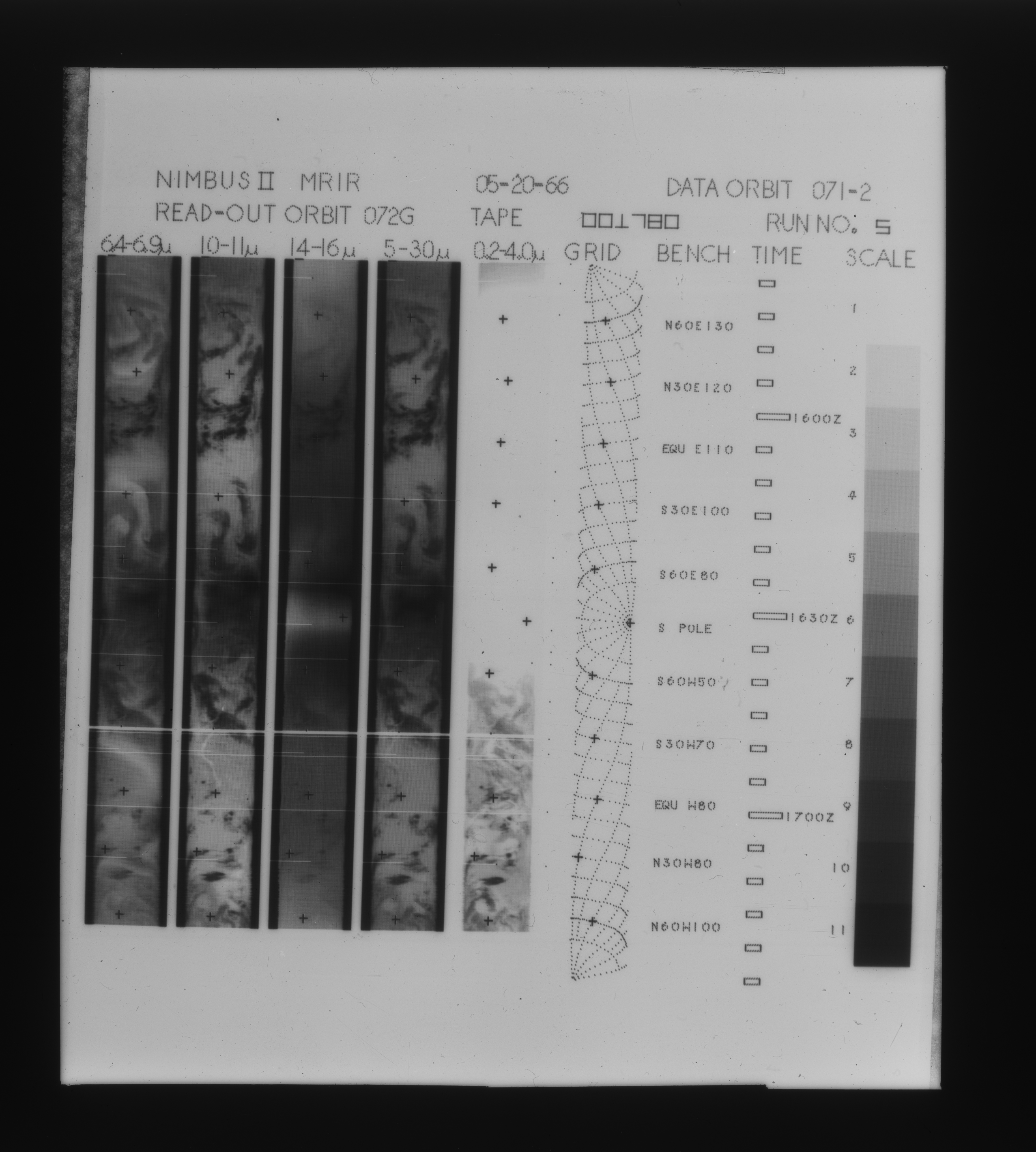
MRIR/Nimbus-2 Level 1 Meteorological Radiation Data V001 (MRIRN2L1) at GES DISC
National Aeronautics and Space Administration —
The Nimbus 2 Medium Resolution Infrared Radiometer (MRIR) was designed to measure electromagnetic radiation emitted and reflected from the earth and its atmosphere at... -
Federal
MODIS/Aqua Aerosol Cloud Water Vapor Ozone Monthly L3 Global 1Deg CMG
National Aeronautics and Space Administration —
The MODIS/Aqua Aerosol Cloud Water Vapor Ozone Monthly L3 Global 1Deg CMG product (MYD08_M3) contains monthly 1 x 1 degree grid average values of atmospheric... -
Federal
IceBridge NSERC L1B Geolocated Meteorologic and Surface Temperature Data, Version 1
National Aeronautics and Space Administration —
This data set is a collection of airborne, in-flight meteorological and in-cabin measurements, as well as thermal emission measurements of near-nadir surface skin... -
Federal
TCSP HIGH ALTITUDE MMIC SOUNDING RADIOMETER (HAMSR) V1
National Aeronautics and Space Administration —
The High Altitude MMIC Sounding Radiometer (HAMSR) is a 25-channel microwave atmospheric sounder operating as a cross-track scanner. There are three bands: an... -
Federal
TCSP CLOUD RADAR SYSTEM (CRS) V1
National Aeronautics and Space Administration —
The TCSP Cloud Radar System (CRS) datasets consists of vertically profiled reflectivity and Doppler velocity at aircraft nadir along the flight track. The CRS is a 94... -
Federal
DISCOVER-AQ Maryland Deployment P-3B Aircraft Merged Data Files
National Aeronautics and Space Administration —
DISCOVERAQ_Maryland_Merge_Data contains pre-generated merged data files created from measurements obtained onboard the P-3B aircraft during the Maryland (Baltimore-... -
Federal
MERRA-2 tavg3_3d_cld_Np: 3d,3-Hourly,Time-Averaged,Pressure-Level,Assimilation,Cloud Diagnostics 0.625 x 0.5 degree V5.12.4 (M2T3NPCLD) at GES DISC
National Aeronautics and Space Administration —
M2T3NPCLD (or tavg3_3d_cld_Np) is a 3-dimensional 3-hourly time averaged data collection in Modern-Era Retrospective analysis for Research and Applications version 2... -
Federal
Sounder SIPS: Suomi NPP CrIMSS Level 2 SiFSAP Support: Atmosphere cloud and surface geophysical state per footprint V2 at GES DISC
National Aeronautics and Space Administration —
This level 2 support product is generated by the SiFSAP (Single Field-of-View Sounder Atmospheric Products) algorithm. The SIFSAP algorithm provides retrieval for... -
Federal
Millersville University Upper Air Radiosondes IMPACTS V1
National Aeronautics and Space Administration —
The Millersville University Upper Air Radiosondes IMPACTS dataset contains atmospheric temperature, dew point temperature, wind speed, and wind direction measurements... -
Federal
Sounder SIPS: Suomi NPP CrIMSS Level 2 CLIMCAPS Full Spectral Resolution: Atmospheric state at Standard Pressure Levels derived from CLIMCAPS V2.1 (SNDRSNIML2PLEVCPS) at GES DISC
National Aeronautics and Space Administration —
The CLIMCAPS (Community Long-term Infrared Microwave Coupled Product System) algorithm is used to analyze data from the Cross-track Infrared Sounder/Advanced... -
Federal
Predicting how varying moisture conditions impact the microbiome of dust collected from the International Space Station (ISS)
National Aeronautics and Space Administration —
On Earth, people spend 90% of their time indoors where dust and moisture can facilitate rapid microbial growth, especially fungi. The International Space Station is a... -
Federal
Pre-LBA Rondonia Boundary Layer Experiment (RBLE) Data
National Aeronautics and Space Administration —
The atmospheric boundary layer (ABL) is the layer of air closest to the ground which is directly influenced on a daily basis by the heating and cooling of the earth's... -
Federal
MODIS/Terra Aerosol Cloud Water Vapor Ozone 8-Day L3 Global 1Deg CMG
National Aeronautics and Space Administration —
The MODIS/Terra Aerosol Cloud Water Vapor Ozone 8-Day L3 Global 1Deg CMG product (MOD08_E3) contains 8-Day 1 x 1 degree grid average values of atmospheric parameters... -
Federal
LBA-ECO LC-02 Forest Flammability Data, Catuaba Experimental Farm, Acre, Brazil: 1998
National Aeronautics and Space Administration —
This data set provides the results of controlled burns conducted to assess the flammability of mature forests on the Catuaba Experimental Farm of the Federal... -
Federal
High Altitude MMIC Sounding Radiometer (HAMSR) CPEX-AW V1
National Aeronautics and Space Administration —
The High Altitude MMIC Sounding Radiometer (HAMSR) CPEX-AW dataset includes measurements gathered by the HAMSR instrument during the Convective Processes Experiment –... -
Federal
CALIPSO Lidar Level 2 Cloud Profile, V4-21
National Aeronautics and Space Administration —
CAL_LID_L2_05kmCPro-Standard-V4-21 is the Cloud-Aerosol Lidar and Infrared Pathfinder Satellite Observations (CALIPSO) Lidar Level 2 Cloud Profile, Version 4-21 data... -
Federal
CALIPSO Lidar Level 2 Aerosol Profile, V4-21
National Aeronautics and Space Administration —
CAL_LID_L2_05kmAPro-Standard-V4-21 is the Cloud-Aerosol Lidar and Infrared Pathfinder Satellite Observations (CALIPSO) Lidar Level 2 Aerosol Profile, Version 4-21...

Official websites use .gov
A
.gov website belongs to an official government
organization in the United States.
Secure .gov websites use HTTPS
A
lock (
) or https:// means you’ve safely connected to
the .gov website. Share sensitive information only on official,
secure websites.