
-
Federal
LMOS Zion Ground Site Data
National Aeronautics and Space Administration —
LMOS_Ground_Zion_Data_1 is the Lake Michigan Ozone Study (LMOS) data collected at the Zion ground site during the LMOS field campaign. This product is a result of a... -
Federal
LMOS Scientific Aviation In-Situ Data
National Aeronautics and Space Administration —
LMOS_AircraftInSitu_ScientificAviation_Data_1 is the Lake Michigan Ozone Study (LMOS) in-situ data collected onboard the Scientific Aviation aircraft during the LMOS... -
Federal
LMOS Milwaukee Ground Site Data
National Aeronautics and Space Administration —
LMOS_Ground_Milwaukee_Data_1 is the Lake Michigan Ozone Study (LMOS) Milwaukee ground site data collected during the LMOS field campaign. This product is a result of... -
Federal
LMOS Grafton Ground Site Data
National Aeronautics and Space Administration —
LMOS_Ground_Grafton_Data_1 is the Lake Michigan Ozone Study (LMOS) Grafton ground site data collected during the LMOS field campaign. This product is a result of a... -
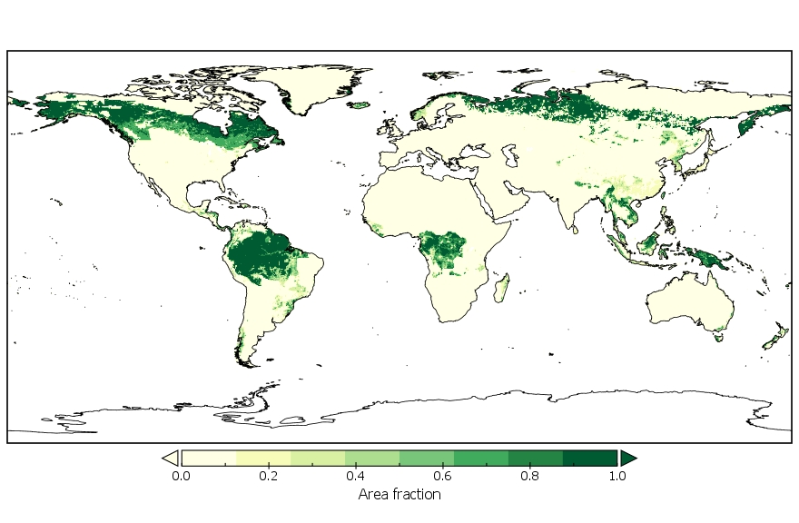
Federal
LUH2-GCB2019: Land-Use Harmonization 2 Update for the Global Carbon Budget, 850-2019
National Aeronautics and Space Administration —
This dataset, referred to as LUH2-GCB2019, includes 0.25-degree gridded, global maps of fractional land-use states, transitions, and management practices for the... -
Federal
LMOS Wisconsin Department of Natural Resources (WDNR) Routine Ground Site Data
National Aeronautics and Space Administration —
LMOS_Ground_WDNRRoutine_Data_1 is the Lake Michigan Ozone Study (LMOS) ground site data collected at the Wisconsin Department of Natural Resources (WDNR) Routine... -
Federal
LMOS Sheboygan Ground Site Data
National Aeronautics and Space Administration —
LMOS_Ground_Sheboygan_Data_1 is the Lake Michigan Ozone Study (LMOS) is Sheboygan ground site data collected during the LMOS field campaign. This product is a result... -
Federal
LMOS Surface Mobile EPA-GMAP Ozone Data
National Aeronautics and Space Administration —
LMOS_TraceGas_SurfaceMobile_EPA-GMAP_Data_1 is the Lake Michigan Ozone Study (LMOS) trace gas surface mobile data collected via the Environmental Protection Agency... -
Federal
SAFARI 2000 FEWS 10-day Rainfall Estimate, 8-Km, 1999-2001
National Aeronautics and Space Administration —
The U.S. Agency for International Development (USAID) Famine Early Warning System (FEWS) has been supporting the production of 10-day Rainfall Estimate (RFE) data for... -
Federal
Polar Radiant Energy in the Far InfraRed Experiment (PREFIRE) Surface Emissivity Sorted All-sky Climatology from PREFIRE Satellite 1 R01
National Aeronautics and Space Administration —
Polar Radiant Energy in the Far InfraRed Experiment (PREFIRE) Surface Emissivity Sorted All-sky Climatology from PREFIRE Satellite 1 (PREFIRE_SAT1_3-SFC-... -
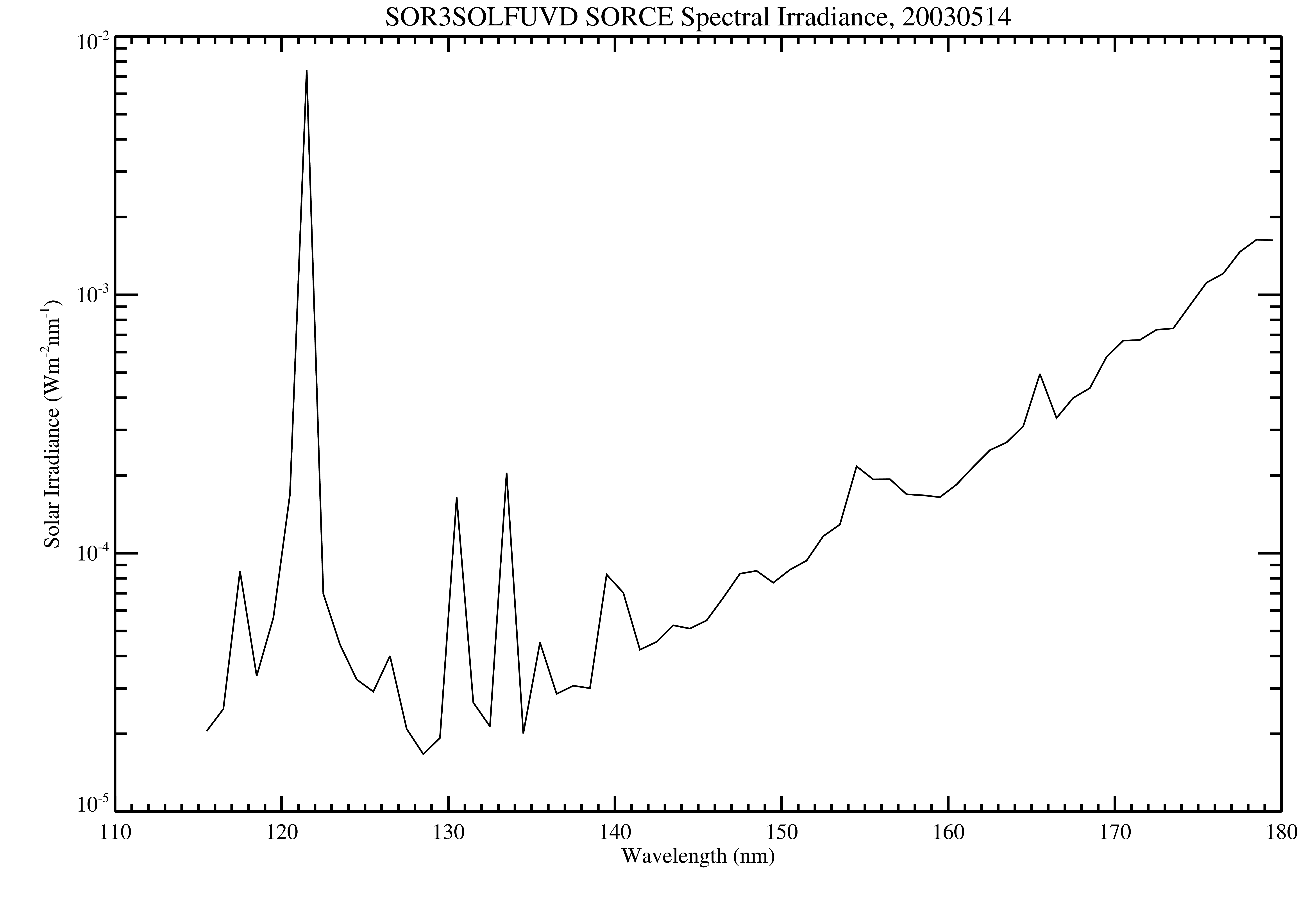
Federal
SORCE SOLSTICE FUV Level 3 Solar Spectral Irradiance Daily Means V018 (SOR3SOLFUVD) at GES DISC
National Aeronautics and Space Administration —
Version 018 is the final version of this data product, and supersedes all previous versions. The SORCE SOLSTICE Far-UV Solar Spectral Irradiance (SSI) data product... -
Federal
RLC AVHRR-Derived Land Cover, Former Soviet Union, Far East, 1-km, 1990
National Aeronautics and Space Administration —
This data set is a 1-kilometer resolution land cover map for the land area of the Primor'ye and Southern Khabarovsk Regions, in the Russian Far East, based on 1990... -
Federal
NCEP/CPC L3 Half Hourly 4km Global (60S - 60N) Merged IR V1 (GPM_MERGIR) at GES DISC
National Aeronautics and Space Administration —
These data originate from NOAA/NCEP. The NOAA Climate Prediction Center/NCEP/NWS is making the data available originally in binary format, in a weekly rotating... -
Federal
NPP Grassland: Consistent Worldwide Site Estimates, 1954-1990, R1
National Aeronautics and Space Administration —
The NPP Database contains documented field measurements of NPP for global terrestrial sites compiled from published literature and other extant data sources. The NPP... -
Federal
LBA-ECO ND-02 Soil Gas Flux, Rainfall Exclusion, km 67, Tapajos National Forest
National Aeronautics and Space Administration —
Moist tropical forests in Amazonia and elsewhere are subjected to increasingly severe drought episodes through the El Nino-Southern Oscillation (ENSO) and possibly... -
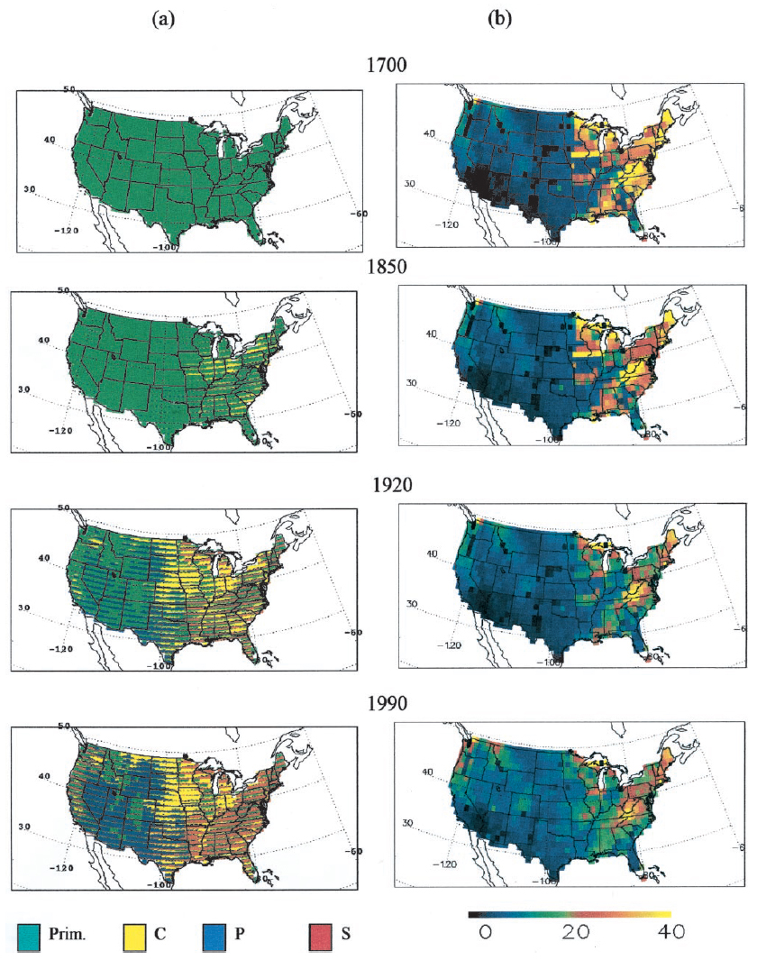
Federal
Ecosystem Demography Model: U.S. Ecosystem Carbon Stocks and Fluxes, 1700-1990
National Aeronautics and Space Administration —
This model product contains the source code for the Ecosystem Demography Model (ED version 1.0) as well as model input and output data files for the conterminous... -
Federal
AKARI/FIS All-Sky Survey Bright Source Catalogue
National Aeronautics and Space Administration —
The AKARI/FIS Bright Source Catalogue Version 1.0 provides the positions and fluxes of 427,071 point sources in the four far-infrared wavelengths centred at 65, 90,... -
Federal
AIRS/Aqua L1B Near Real Time (NRT) Infrared (IR) geolocated and calibrated radiances V005 (AIRIBRAD_NRT) at GES DISC
National Aeronautics and Space Administration —
WARNING: On 2021/09/23 the EOS Aqua executed a Deep Space Maneuver (DSM). In the DSM, the spacecraft is turned such that the normal Earth field of regard is deep... -
Federal
ICON The Far Ultra Violet Imaging Spectrograph Day Limb Images
National Aeronautics and Space Administration —
The FUV instrument takes 2D images of the Earth’s horizon in the Far ultraviolet. \n The imager is pointing approximately 90 degrees to the spacecraft motion, similar...

Official websites use .gov
A
.gov website belongs to an official government
organization in the United States.
Secure .gov websites use HTTPS
A
lock (
) or https:// means you’ve safely connected to
the .gov website. Share sensitive information only on official,
secure websites.