
-
Federal
MISR Level 3 FIRSTLOOK Global Land product in netCDF format covering a month V002
National Aeronautics and Space Administration —
MI3MLSNF_002 is the Multi-angle Imaging SpectroRadiometer (MISR) Level 3 FIRSTLOOK Global Land product in netCDF format covering a month version 2 data product. It... -
Federal
Mediterranean Sea Ultra High Resolution SST L4 Analysis 0.01 deg Resolution
National Aeronautics and Space Administration —
CNR MED Sea Surface Temperature provides daily gap-free maps (L4) at 0.01 deg. x 0.01deg. horizontal resolution over the Mediterranean Sea. The data are obtained from... -
Federal
MISR Level 3 Component Global Radiance Product covering a day subset for the UAE region V004
National Aeronautics and Space Administration —
UAEMRDRD_004 is the Multi-angle Imaging SpectroRadiometer (MISR) Level 3 Component Global Radiance Product covering a day subset for the UAE region version 4. It... -
Federal
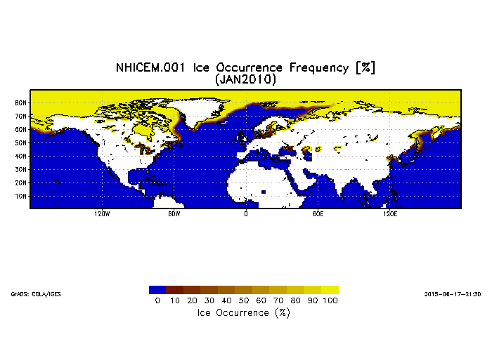
Northern Hemisphere Ice Cover Monthly Statistics at 1 Degree Resolution V001 (NHICEM) at GES DISC
National Aeronautics and Space Administration —
This product is monthly Ice Cover Statistics. The dataset was prepared by Dr. Peter Romanov at Cooperative Institute for Climate Studies(CICS) of the University of... -
Federal
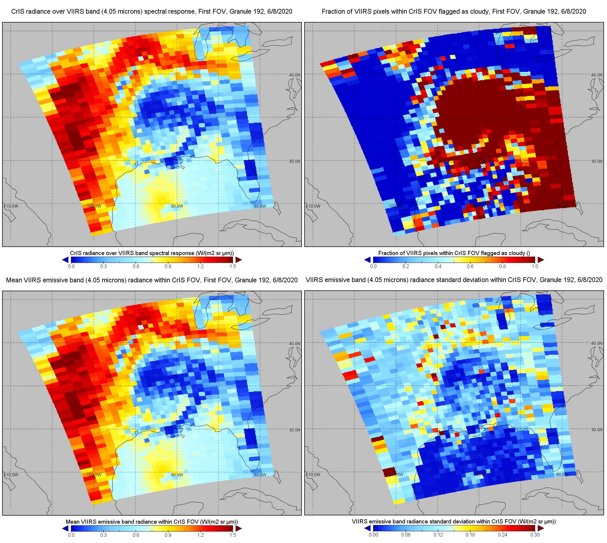
S-NPP CrIS IMG: Collocated VIIRS level 1 / cloud mask statistical summary V2 (SNDRSNCrISL1BIMG) at GES DISC
National Aeronautics and Space Administration —
The Cross-track Infrared Sounder (CrIS) Level 1B Normal Spectral Resolution (NSR) data files contain radiance measurements along with ancillary spacecraft,... -
Federal
SAFARI 2000 ASTER and MODIS Fire Data Comparison, Dry Season 2001
National Aeronautics and Space Administration —
These data relate to a paper (Morisette et al., 2005) that describes the use of high spatial resolution ASTER data to determine the accuracy of the moderate... -
Federal
VIIRS/SNPP Cloud Properties COSP Level 3 monthly, 1x1 deg. grid
National Aeronautics and Space Administration —
The VIIRS/SNPP Cloud Properties COSP Level 3 monthly, 1x1 degree grid product is a new L3 CLDPROP COSP Cloud product with short-name CLDPROPCOSP_M3_VIIRS_SNPP. It... -
Federal
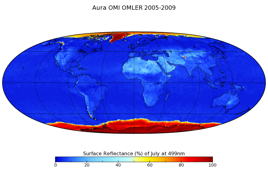
OMI/Aura Surface Reflectance Climatology L3 Global Gridded 0.5 degree x 0.5 degree V3 (OMLER) at GES DISC
National Aeronautics and Space Administration —
The OMI Earth Surface Reflectance Climatology product, OMLER (Global 0.5 degrees Lat/Lon grid) which is based on Version 003 Level-1B top of atmosphere upwelling... -
Federal
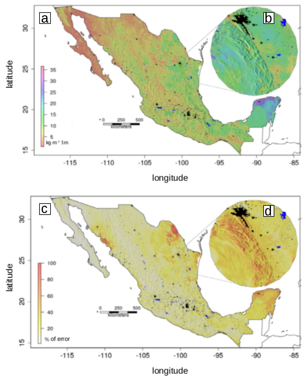
Soil Organic Carbon Estimates and Uncertainty at 1-m Depth across Mexico, 1999-2009
National Aeronautics and Space Administration —
This dataset provides an estimate of soil organic carbon (SOC) in the top one meter of soil across Mexico at a 90-m resolution for the period 1999-2009. Carbon... -
Federal
Soil Moisture Release Data (FIFE)
National Aeronautics and Space Administration —
This data product was created based on the hypothesis that a variety of ground truth observations of soil moisture could be combined to estimate equal soil moisture... -
Federal
Spatial Statistical Data Fusion (SSDF) Level 3: CONUS Near-Surface Atmospheric Temperature from Aqua AIRS, V2 (SNDRAQIL3SSDFCNSAT)
National Aeronautics and Space Administration —
This data set provides an estimate of the surface air temperature. It infers a value for each grid point based on nearby and distant values of the input Level-2... -
Federal
Spatial Statistical Data Fusion (SSDF) Level 3: CONUS Near-Surface Atmospheric Temperature from SNPP CrIMSS and Aqua AIRS, V2 (SNDR13IML3SSDFCNSAT)
National Aeronautics and Space Administration —
This data set provides an estimate of the surface air temperature. It infers a value for each grid point based on nearby and distant values of the input Level-2... -
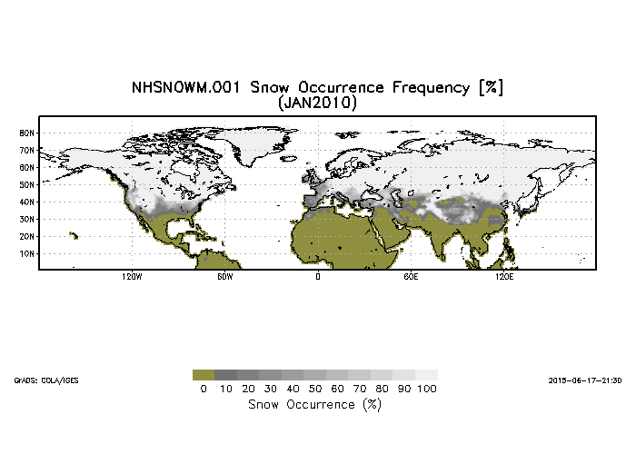
Federal
Northern Hemisphere Snow Cover Monthly Statistics at 1 Degree Resolution V001 (NHSNOWM) at GES DISC
National Aeronautics and Space Administration —
This product is Snow Cover Statistics. The dataset was prepared by Dr. Peter Romanov at Cooperative Institute for Climate Studies(CICS) of the University of Maryland... -
Federal
NOAA GHRSST Level 2P Atlantic Ocean Regional Skin Sea Surface Temperature v1.0 from the Spinning Enhanced Visible and InfraRed Imager (SEVIRI) on the Meteosat Second Generation-4 (MSG-4) satellite
National Aeronautics and Space Administration —
The GHRSST L2P MSG04 SST v1.0 dataset is produced by the US National Oceanic and Atmospheric Administration (NOAA) National Environmental Satellite, Data, and... -
Federal
NOAA GHRSST Level 2P Indian Ocean Regional Skin Sea Surface Temperature v1.0 from the Spinning Enhanced Visible and InfraRed Imager (SEVIRI) on the Meteosat Second Generation-1 (MSG-1) satellite
National Aeronautics and Space Administration —
The GHRSST L2P MSG01 SST v1.0 dataset is produced by the US National Oceanic and Atmospheric Administration (NOAA) National Environmental Satellite, Data, and... -
Federal
Aircraft Flux-Detrended: U of Wy. (FIFE)
National Aeronautics and Space Administration —
The University of Wyoming (UW) King Air atmospheric boundary layer measurement missions were flown in 1987 during IFCs 3 and 4. This Boundary Layer Fluxes data set... -
Federal
Aircraft Flux-Raw: U of Wy. (FIFE)
National Aeronautics and Space Administration —
The University of Wyoming (UW) King Air atmospheric boundary layer measurement missions were flown in 1987 during IFCs 3 and 4. This Raw Boundary Layer Fluxes data... -
Federal
GHRSST Level 4 MW_IR_OI Global Foundation Sea Surface Temperature analysis version 5.1 from REMSS
National Aeronautics and Space Administration —
A Group for High Resolution Sea Surface Temperature (GHRSST) global Level 4 sea surface temperature analysis produced daily on a 0.09-degree grid at Remote Sensing... -
Federal
GHRSST Level 4 MW_OI Global Foundation Sea Surface Temperature analysis version 5.0 from REMSS
National Aeronautics and Space Administration —
A Group for High Resolution Sea Surface Temperature (GHRSST) global Level 4 sea surface temperature analysis produced daily on a 0.25-degree grid at Remote Sensing... -
Federal
GHRSST Level 4 MW_OI Global Foundation Sea Surface Temperature analysis version 5.1 from REMSS
National Aeronautics and Space Administration —
A Group for High Resolution Sea Surface Temperature (GHRSST) global Level 4 sea surface temperature analysis produced daily on a 0.25-degree grid at Remote Sensing...

Official websites use .gov
A
.gov website belongs to an official government
organization in the United States.
Secure .gov websites use HTTPS
A
lock (
) or https:// means you’ve safely connected to
the .gov website. Share sensitive information only on official,
secure websites.