
-
Federal
Benthic Habitats of Kauai Derived From IKONOS and Quick Bird Satellite Imagery, 2004-2006
National Oceanic and Atmospheric Administration, Department of Commerce —
This project is a cooperative effort between the National Ocean Service, National Centers for Coastal Ocean Science, Center for Coastal Monitoring and Assessment, the... -
Federal
H13712: NOS Hydrographic Survey , 2023-07-06
National Oceanic and Atmospheric Administration, Department of Commerce —
The National Oceanic and Atmospheric Administration (NOAA) has the statutory mandate to collect hydrographic data in support of nautical chart compilation for safe... -
Federal
H13667: NOS Hydrographic Survey , 2022-09-17
National Oceanic and Atmospheric Administration, Department of Commerce —
The National Oceanic and Atmospheric Administration (NOAA) has the statutory mandate to collect hydrographic data in support of nautical chart compilation for safe... -
Federal
H13556: NOS Hydrographic Survey , 2022-11-05
National Oceanic and Atmospheric Administration, Department of Commerce —
The National Oceanic and Atmospheric Administration (NOAA) has the statutory mandate to collect hydrographic data in support of nautical chart compilation for safe... -
Federal
H13708: NOS Hydrographic Survey , 2023-06-08
National Oceanic and Atmospheric Administration, Department of Commerce —
The National Oceanic and Atmospheric Administration (NOAA) has the statutory mandate to collect hydrographic data in support of nautical chart compilation for safe... -
Federal
H13691: NOS Hydrographic Survey , 2022-11-13
National Oceanic and Atmospheric Administration, Department of Commerce —
The National Oceanic and Atmospheric Administration (NOAA) has the statutory mandate to collect hydrographic data in support of nautical chart compilation for safe... -
Federal
H13704: NOS Hydrographic Survey , 2023-06-29
National Oceanic and Atmospheric Administration, Department of Commerce —
The National Oceanic and Atmospheric Administration (NOAA) has the statutory mandate to collect hydrographic data in support of nautical chart compilation for safe... -
Federal
Nutrient constituents measured from sediment cores collected in the Chesapeake Bay from 2008-10-26 to 2008-10-27 (NCEI Accession 0305565)
National Oceanic and Atmospheric Administration, Department of Commerce —
This accession contains nutrient constituents, such as total phosphorus (TP), inorganic phosphorus (IP), percent nitrogen, percent carbon, absolute TP and IP, and... -
Federal
NCCOS Mapping: Collaborative Benthic Habitat Mapping in the Nearshore Waters of the Great Lakes Basin â Collection locations of GL-25-02 cruise benthic imagery and sediment samples in Lake Superior, offshore of Duluth, Minnesota and Superior, Wisconsin 2025-07-14 to 2025-08-01 (NCEI Accession 0312024)
National Oceanic and Atmospheric Administration, Department of Commerce —
This dataset includes collection locations associated with sites sampled within the nearshore waters of Duluth, Wisconsin in Lake Superior. Site information data was... -
Federal
NCCOS Assessment: Post placement vegetation, sediment, and imagery data from Deal Island Wildlife Management area, MD, 2024-07-22 to 2025-07-29 (NCEI Accession 0310721)
National Oceanic and Atmospheric Administration, Department of Commerce —
The Deal Island beneficial use project involved raising the marsh platform's elevation using dredged material from the lower Wicomico River. NCCOS researchers... -
Federal
Chemical, physical, profile and laboratory analysis oceanographic data collected aboard the F. G. Walton Smith in the Gulf of Mexico from 2010-05-26 to 2010-06-02 in response to the Deepwater Horizon Oil Spill event (NCEI Accession 0069084)
National Oceanic and Atmospheric Administration, Department of Commerce —
Chemical, physical, profile and laboratory analysis oceanographic data were collected aboard the F. G. Walton Smith in the Gulf of Mexico from 2010-05-26 to... -
Federal
National Park Service St. Croix National Scenic Riverway - Osceola Bed Observations, 20191017
Department of the Interior —
The U.S. Geological Survey (USGS) collected hydroacoustic data of the St. Croix River adjacent to the Osceola (WI) boat ramp for hydrographic and benthic mapping... -
Federal
Predicting sediment responses to different management scenarios for Lake Powell releases
Department of the Interior —
These data were compiled for/to modeling to assess impact of management scenarios on Colorado River sediment resources. Objective(s) of our study were to assess... -
Federal
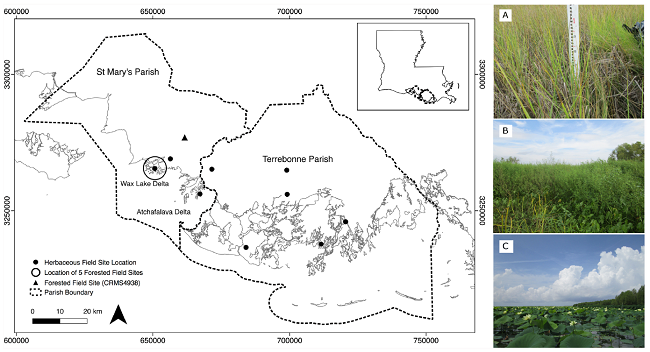
Pre-Delta-X: Vegetation Species, Structure, Aboveground Biomass, MRD, LA, USA, 2015
National Aeronautics and Space Administration —
This dataset provides vegetation species, height, stem density and diameter, and species aboveground biomass (AGB) measurements collected at herbaceous and forested... -
Federal
Portable Remote Imaging SpectroMeter (PRISM) from Elkhorn Slough to Monterey Bay, California
National Aeronautics and Space Administration —
The estuarine waters of Elkhorn Slough terminating in Monterey Bay, California present an excellent study site for testing the limits of hyperspectral imaging... -
Federal
Sediment Grab Data from September 2001 in Wells, Maine (wellssedgrabs)
National Oceanic and Atmospheric Administration, Department of Commerce —
In fall 2001, researchers from the Wells National Estuarine Research Reserve, Virginia Institute of Marine Science, and the NOAA Office for Coastal Management... -
Federal
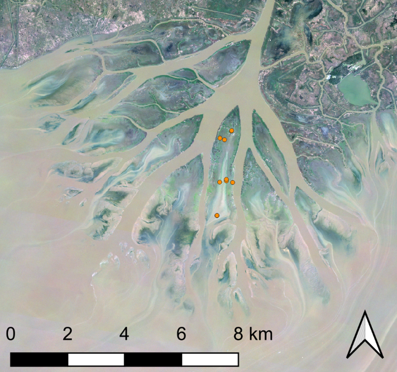
Delta-X: Sediment Core Grain Size Distribution, Wax Lake Delta, MRD, LA
National Aeronautics and Space Administration —
This dataset provides grain size distribution measurements collected from sediment core samples on Mike Island in the Wax Lake Delta, Louisiana, as part of the... -
Federal
American River At Folsom Powerhouse Chloride ug/L Time Series Data
Department of the Interior —
Measurements of Chloride collected at American River At Folsom Powerhouse. Currently collected twice a year, previously collected quarterly. Access further... -
Federal
Lake Clementine Uranium ug/L Time Series Data
Department of the Interior —
Measurements of Uranium collected at Lake Clementine. Currently collected twice a year, previously collected quarterly. Access further information for this data set... -
Federal
Fire vs Water: Erosional/Depositional Geology, Hawaiian Islands
National Oceanic and Atmospheric Administration, Department of Commerce —
Even a casual, untrained observer will see evidence that opposing forces have formed the Hawaiian Islands. The massive and lofty volcanoes have been scoured, abraded,...

Official websites use .gov
A
.gov website belongs to an official government
organization in the United States.
Secure .gov websites use HTTPS
A
lock (
) or https:// means you’ve safely connected to
the .gov website. Share sensitive information only on official,
secure websites.