
-
Federal
ENVISAT MERIS Global Binned Cyanobacteria Index (CI) Data, version 5.0
National Aeronautics and Space Administration —
Cyanobacteria Assessment Network (CyAN) is a multi-agency project among EPA, the National Aeronautics and Space Administration (NASA), the National Oceanic and... -
Federal
LBA-ECO CD-03 Cloud Base-Backscatter Data, km 67 Tower Site, Tapajos National Forest
National Aeronautics and Space Administration —
A Vaisala CT-25K ceilometer was installed at an old-growth forest site located at the km 67 Eddy Flux Tower site in the Tapajos National Forest, Para, Brazil, off... -
Federal
Landsat-Derived Global Rainfed-Cropland Product L1 2020 30 m V002
National Aeronautics and Space Administration —
The Landsat-Derived Global Rainfed-Cropland Product Level 1 2020 (LGRIP30_L1_RAIN) Version 2 data provides high-resolution, 30 meter (m) cropland data to assist and... -
Federal
CYGNSS Level 2 Climate Data Record Version 1.1
National Aeronautics and Space Administration —
This dataset contains the Version 1.1 CYGNSS Level 2 Climate Data Record which provides the time-tagged and geolocated average wind speed (m/s) and mean square slope... -
Federal
CYGNSS Level 3 Climate Data Record Version 1.0
National Aeronautics and Space Administration —
This dataset contains the Version 1.0 CYGNSS Level 3 Climate Data Record which provides the average wind speed and mean square slope (MSS) on a 0.2x0.2 degree... -
Federal
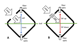
BOREAS TE-12 Leaf Optical Data for SSA Species
National Aeronautics and Space Administration —
The BOREAS TE-12 team collected several data sets in support of its efforts to characterize and interpret information on the reflectance, transmittance, and gas... -
Federal
BOREAS RSS-08 IFC-3 ADS-PSII Measurements of BRDF at SSA-OBS and SSA-OA Sites
National Aeronautics and Space Administration —
Ground BRDF measurements were acquired by the Remote Sensing Science (RSS)-08 team to aid in the development of advanced spectral vegetation indices. The RSS-08 team... -
Federal
CARVE: Fire-Related Aerosol and Soil Elemental and Isotopic Composition, Alaska, 2013
National Aeronautics and Space Administration —
This data set provides measurements of the isotopic composition of black carbon and organic carbon aerosols collected at two locations in interior Alaska during the... -
Federal
VIIRS/NPP Moderate Resolution Bands L1B 6-Min Swath 750m NRT
National Aeronautics and Space Administration —
The VIIRS Level 1 and Level 2 swath products are generated from the processing of 6 minutes of VIIRS data acquired during the S-NPP satellite overpass. The VIIRS... -
Federal
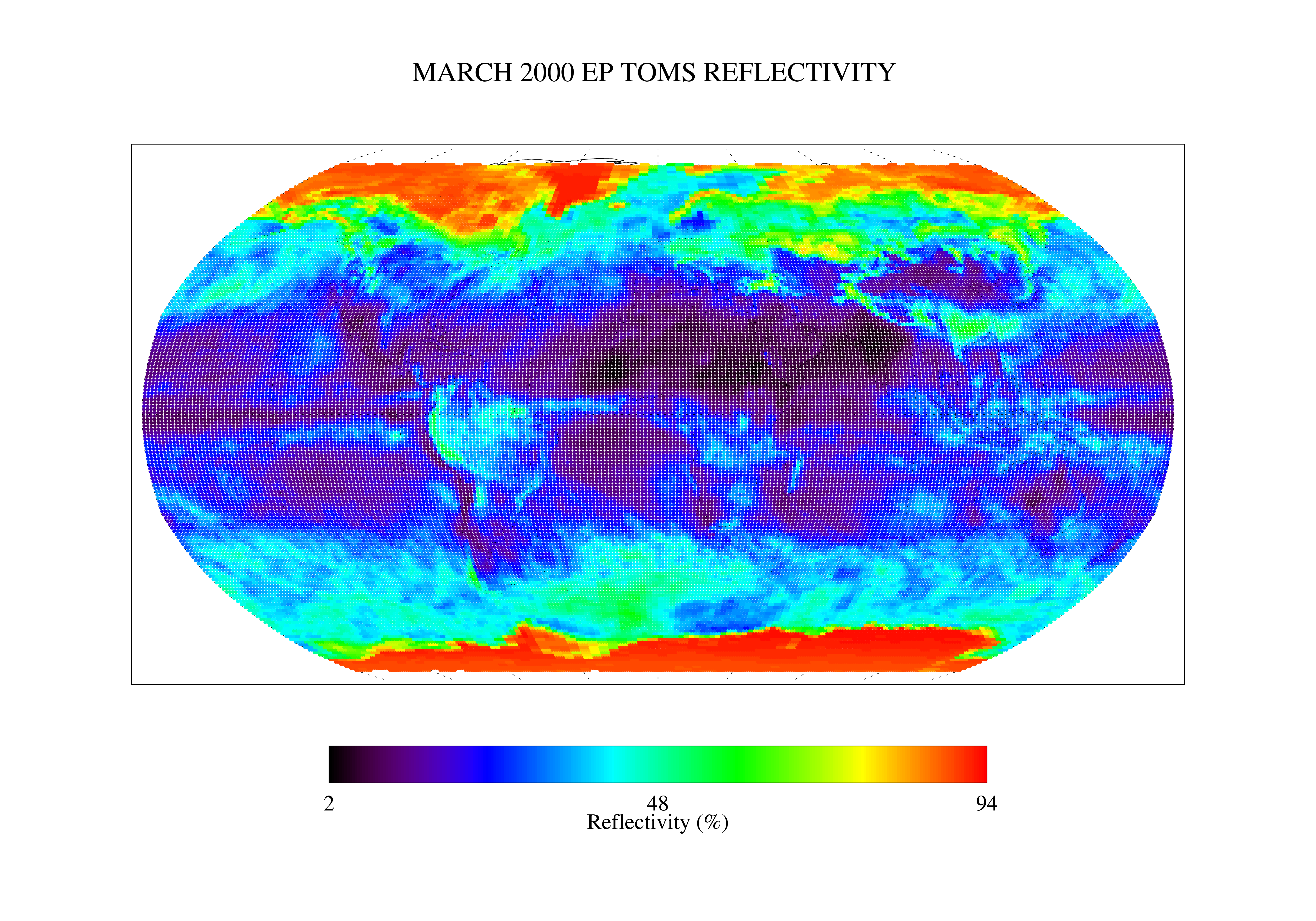
TOMS Earth Probe UV Reflectivity Monthly L3 Global 1 deg x 1.25 deg Lat/Lon Grid V008 (TOMSEPL3mref) at GES DISC
National Aeronautics and Space Administration —
This Earth Probe (EP) Total Ozone Mapping Spectrometer (TOMS) version 8 monthly averaged global gridded data product contains Lambertian effective surface... -
Federal
VIIRS/NPP BRDF/Albedo WSA at Solar Noon NIR Daily L3 Global 30ArcSec CMG V001
National Aeronautics and Space Administration —
The VNP43D77 Version 1 data product was decommissioned on July 31, 2025. Users are encouraged to use theFederalTundra Plant Leaf-level Spectral Reflectance and Chlorophyll Fluorescence, 2019-2021
National Aeronautics and Space Administration —
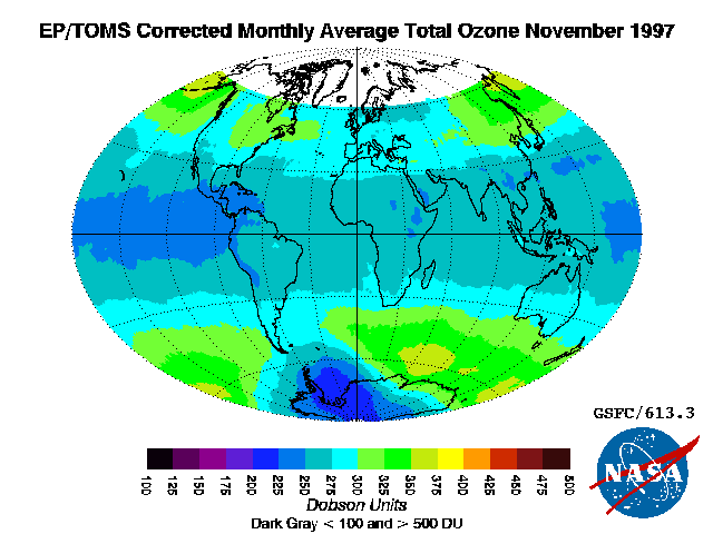
This dataset provides leaf-level visible-near infrared spectral reflectance, chlorophyll fluorescence spectra, species, plant functional type (PFT), and chlorophyll...FederalTOMS Earth Probe Total Column Ozone Monthly L3 Global 1 deg x 1.25 deg Lat/Lon Grid V008 (TOMSEPL3mtoz) at GES DISC
National Aeronautics and Space Administration —
This Earth Probe (EP) Total Ozone Mapping Spectrometer (TOMS) version 8 monthly averaged global gridded data product contains total column ozone values. The data are...FederalPermafrost monitoring and prediction in Southern Carpathians, Romania, Version 1
National Aeronautics and Space Administration —
This study monitored the summer temperatures (July and August) of the springs at the base of the rock glaciers' fronts and talus cones of Fagaras and Retezat...FederalSatellite Laser Ranging (SLR) International Laser Ranging Service (ILRS) Data Handling Files
National Aeronautics and Space Administration —
In the ILRS network, there are mobile systems and permanent systems. Mobile ILRS systems usually occupy (i.e. are referenced to) a ground monument/mark and have an...FederalHydrologic Sub-basins of Greenland, Version 1
National Aeronautics and Space Administration —
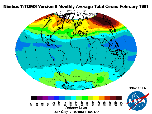
The Hydrologic Sub-basins of Greenland data set contains Geographic Information System (GIS) polygon shapefiles that include 293 hydrologic sub-basins of the...FederalTOMS Nimbus-7 Total Column Ozone Monthly L3 Global 1 deg x 1.25 deg Lat/Lon Grid V008 (TOMSN7L3mtoz) at GES DISC
National Aeronautics and Space Administration —
This Nimbus-7 Total Ozone Mapping Spectrometer (TOMS) version 8 monthly averaged global gridded data product contains total column ozone values. The data are mapped...FederalPre SWOT Hydrology Global Lake/Reservoir Storage Time Series V2
National Aeronautics and Space Administration —
The Global Lake/Reservoir Storage Time Series is derived from the Surface Water Height Time Series and Surface Water Extent Mask Time Series products. The purpose of...FederalTOVS LMD 5 DAY GRIDS from NOAA-12 V01 (TOVSB5ND) at GES DISC
National Aeronautics and Space Administration —
Level 3 parameters from HIRS/2 and MSU radiances using the Improved Initialization Inversion (3I) classification retrieval scheme by the Laboratoire de Meteorologie...FederalMODIS/Aqua Land Surface Temperature/Emissivity Monthly L3 Global 0.05Deg CMG V006
National Aeronautics and Space Administration —
The MYD11C3 Version 6 data product was decommissioned on July 31, 2023. Users are encouraged to use the MYD11C3...9,585 datasets found

Official websites use .gov
A
.gov website belongs to an official government
organization in the United States.
Secure .gov websites use HTTPS
A
lock (
) or https:// means you’ve safely connected to
the .gov website. Share sensitive information only on official,
secure websites.