
-
Federal
1995 Average Monthly Sea Surface Temperature for California
National Oceanic and Atmospheric Administration, Department of Commerce —
The NOAA/ NASA AVHRR Oceans Pathfinder sea surface temperature data are derived from the 5-channel Advanced Very High Resolution Radiometers (AVHRR) on board the NOAA... -
State
Commercial Herring Fishery Monitoring Data - San Francisco Bay
State of California —
Nearshore and Bays Management Project manages the commercial herring fishery in CA. Data used in this management includes age, maturity, and weight data. Monitoring... -
Federal
MCC Country Program Data - FY25Q4 August
Millennium Challenge Corporation —
Cumulative program data for all of the Millennium Challenge Corporation's programs, including financial, conditions, and results data. -
Federal
Multibeam collection for HLY08TG: Multibeam data collected aboard Healy from 25-Jun-08 to 02-Jul-08, Seattle, Washington to Dutch Harbor, Alaska
National Oceanic and Atmospheric Administration, Department of Commerce —
This data set is part of a larger set of data called the Multibeam Bathymetry Database (MBBDB) where other similar data can be found -
Federal
Multibeam collection for HLY06TG: Multibeam data collected aboard Healy from 08-Jul-06 to 18-Jul-06, Everett, Washington to Barrow, Alaska
National Oceanic and Atmospheric Administration, Department of Commerce —
This data set is part of a larger set of data called the Multibeam Bathymetry Database (MBBDB) where other similar data can be found -
Federal
LBA-ECO CD-10 Temperature Profiles at km 67 Tower Site, Tapajos National Forest
National Aeronautics and Space Administration —
This data set reports temperature measurements at the Para Western (Santarem) - km 67, Primary Forest Tower Site. This site is in the Tapajos National Forest located... -
Federal
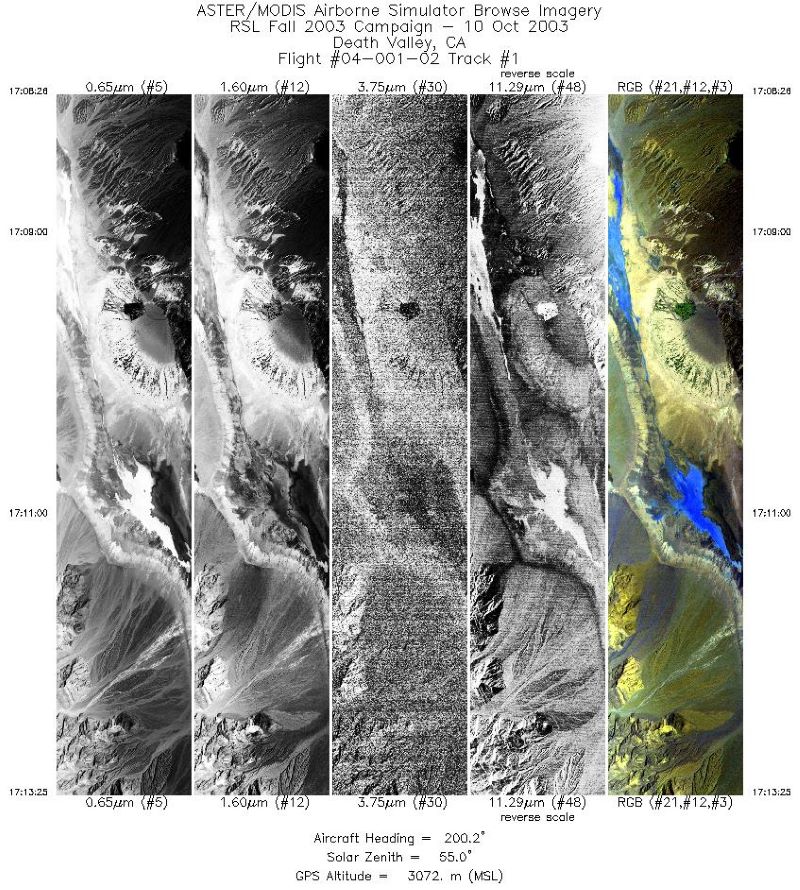
MASTER: Geological fault mapping, California-Nevada, October, 2003
National Aeronautics and Space Administration —
This dataset includes Level 1B (L1B) data products from the MODIS/ASTER Airborne Simulator (MASTER) instrument. The spectral data were collected during six flights... -
Federal
LBA-ECO TG-03 Aeronet Aerosol Optical Thickness Measurements, Brazil: 1993-2005
National Aeronautics and Space Administration —
This data set includes aerosol optical thickness measurements from the CIMEL sunphotometer for 22 sites in Brazil during the period from 1993-2005. The AERONET... -
Federal
LBA-ECO TG-07 Seasonal Trace Gas Profiles in Brazilian Amazon Forests: 2004-2005
National Aeronautics and Space Administration —
This data set provides concentrations of carbon dioxide (CO2), methane (CH4), and nitrous oxide (N2O) from air samples collected at several heights on towers at three... -
Federal
LBA-ECO TG-07 Fallen and Standing Necromass, Tapajos, Cauaxi, Juruena Forests, Brazil
National Aeronautics and Space Administration —
This data set reports the characterization of fallen necromass as the volume and density of coarse woody debris (CWD), and standing necromass as the volume and... -
Federal
LBA-ECO TG-07 Litter Decomposition, Tapajos National Forest, Para, Brazil: 2000-2001
National Aeronautics and Space Administration —
Once the weathering of parent material ceases to supply significant inputs of phosphorus (P), vegetation depends largely on the decomposition of litter and soil... -
Federal
LBA-ECO TG-07 Soil Trace Gas Flux and Root Mortality, Tapajos National Forest
National Aeronautics and Space Administration —
We conducted an experiment on sand and clay tropical forest soils to test the short-term effect of root mortality on the soil-atmosphere flux of nitrous oxide, nitric... -
Federal
LBA-ECO TG-07 Tree Geometry in an Undisturbed Forest in Cauaxi, Para, Brazil
National Aeronautics and Space Administration —
Canopy measurements in an undisturbed eastern Amazon forest (Cauxi, Para, Brazil. See Figure 1) were derived from a one-time event in 2000 using a hand-held laser... -
Federal
LBA-ECO TG-07 Trace Gas Fluxes, Undisturbed and Logged Sites, Para, Brazil: 2000-2002
National Aeronautics and Space Administration —
Selective logging is an extensive land use in the Brazilian Amazon region. We studied the soil-atmosphere fluxes of nitrous oxide (N2O), nitric oxide (NO), methane... -
Federal
LBA-ECO TG-09 Soil Isotopic C, N, H2O, and N2O Data, Tapajos National Forest, Brazil
National Aeronautics and Space Administration —
This data set reports the results of carbon, nitrogen, and oxygen isotopic analyses of soil, soil water, and N2O soil gas samples; total soil carbon and nitrogen... -
Federal
VIIRS/JPSS1 DNB BRDF/Albedo Model Parameters Daily L3 Global 1km SIN Grid V002
National Aeronautics and Space Administration —
The NOAA-20 Visible Infrared Imaging Radiometer Suite (VIIRS) Day/Night Band (DNB) Bidirectional Reflectance Distribution Function (BRDF) and Albedo Model Parameters... -
Federal
VIIRS validation measurements made in the Florida Keys
National Aeronautics and Space Administration —
Measurements made in the Florida Keys as part of efforts to Validate the VIIRS instrument. -
Federal
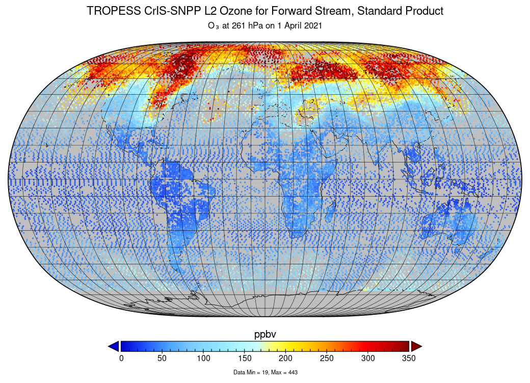
TROPESS CrIS-SNPP L2 Ozone for Forward Stream, Standard Product V1 (TRPSDL2O3CRSFS) at GES DISC
National Aeronautics and Space Administration —
The TROPESS CrIS-SNPP L2 Ozone for Forward Stream, Standard Product contains the vertical distribution of the retrieved atmospheric state of ozone (O3), formal... -
Federal
ACE Electron Proton Alpha Monitor (EPAM) LEFS150 MFSA, Spacecraft Frame, Sectored Proton Fluxes, Hourly Averages
National Aeronautics and Space Administration —
Hourly-averaged sectored proton fluxes from the MF Spectrum Analyzer of the ACE/EPAM LEFS150 instrument. All energies thresholds take into account the incident... -
Federal
Australia Telescope Chandra Deep Field-South and SDSS Stripe 82 20-GHz Sources
National Aeronautics and Space Administration —
This table contains a source catalog, one of the first results from a deep, blind radio survey carried out at 20 GHz with the Australia Telescope Compact Array, with...

Official websites use .gov
A
.gov website belongs to an official government
organization in the United States.
Secure .gov websites use HTTPS
A
lock (
) or https:// means you’ve safely connected to
the .gov website. Share sensitive information only on official,
secure websites.