
-
Federal
The ABCflux Database: Arctic-Boreal CO2 Flux and Site Environmental Data, 1989-2020
National Aeronautics and Space Administration —
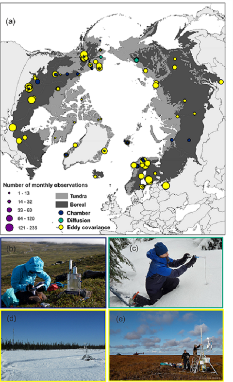
This Arctic-Boreal CO2 fluxes (ABCflux) dataset contains monthly aggregates of terrestrial net ecosystem CO2 exchange and its derived partitioned component fluxes:... -
Federal
NOAA/WDS Paleoclimatology - North Greenland Eemian (NEEM) Ice Core 107KYr High-Resolution Methane Data
National Oceanic and Atmospheric Administration, Department of Commerce —
This archived Paleoclimatology Study is available from the NOAA National Centers for Environmental Information (NCEI), under the World Data Service (WDS) for... -
Federal
CERES Single Scanner Footprint (SSF) TOA/Surface Fluxes, Clouds and Aerosols Terra-FM1 Edition4A
National Aeronautics and Space Administration —
CER_SSF_Terra-FM1-MODIS_Edition4A is the Clouds and the Earth's Radiant Energy System (CERES) Single Scanner Footprint (SSF) Top-of-the-Atmosphere (TOA)/Surface... -
Federal
EnviroAtlas - Tampa, FL - 15m Riparian Buffer Vegetated Cover
U.S. Environmental Protection Agency —
This EnviroAtlas dataset describes the percentage of a 15-m riparian buffer that is vegetated. There is a potential for decreased water quality in areas where the... -
Federal
ABoVE: Active Layer Thickness from Remote Sensing Permafrost Model, Alaska, 2001-2015
National Aeronautics and Space Administration —
This dataset provides annual estimates of active layer thickness (ALT) at 1 km resolution across Alaska from 2001-2015. The ALT was estimated using a remote sensing-... -
Federal
Arctic Vegetation Plots at ARCSS/LAII Flux Sites, North Slope, Alaska, 1995-1996
National Aeronautics and Space Administration —
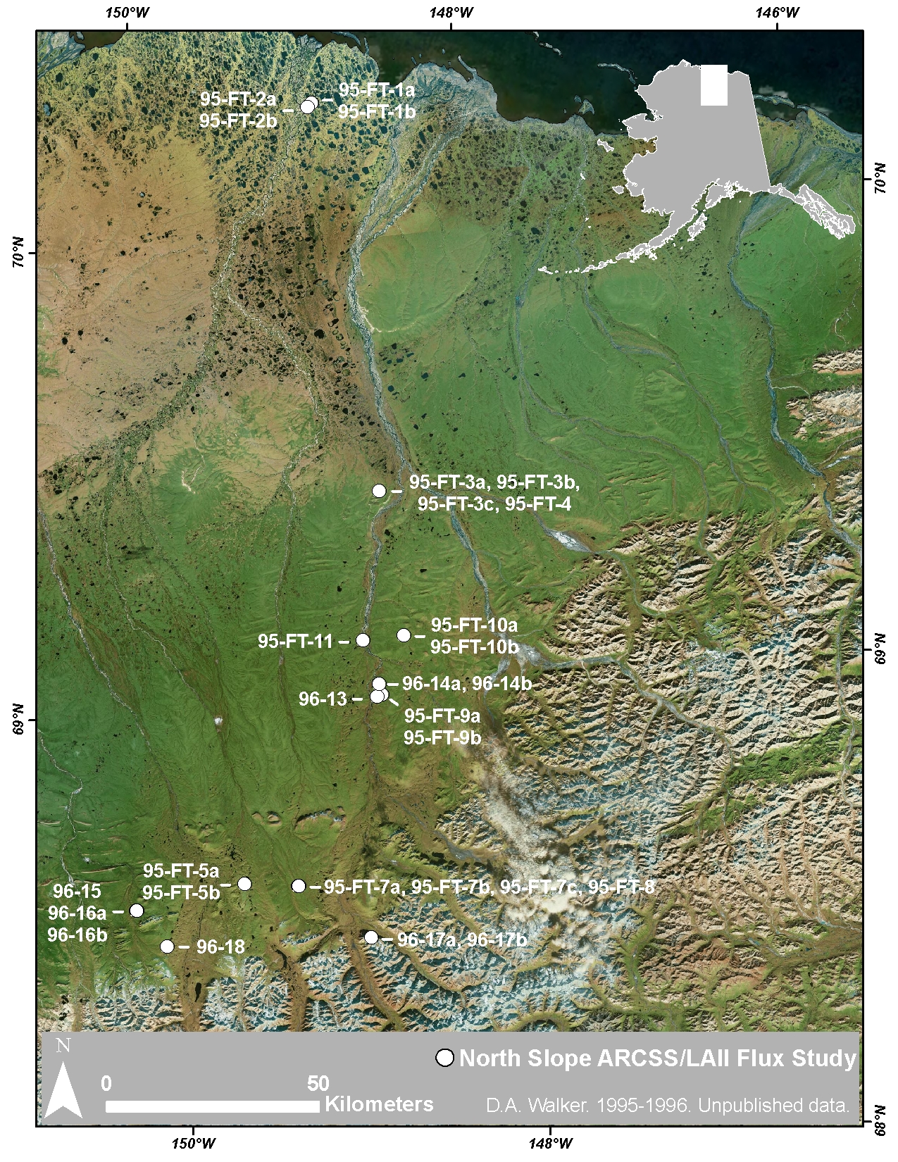
This dataset provides vegetation cover and environmental plot and soil data collected at flux tower sites of the North Slope Arctic System Science/Land-Atmosphere-Ice... -
Federal
CARVE: Daily Thaw State of Boreal and Arctic Alaska from AMSR-E and SSM/I, 2003-2014
National Aeronautics and Space Administration —
This data set provides daily 10 km resolution maps of the Alaskan and Arctic Boreal land surface state as either frozen, melting, or thawed. These data are generated... -
Federal
BETA - Hazard Exposure: National Highway System Bridges NGDA
Federal Geographic Data Committee —
The BETA - Hazard Exposure: National Highway System Bridges dataset was updated on October 16, 2025 from the Bureau of Transportation Statistics (BTS) and is part of... -
Federal
BOREAS HYD-03 Snow Temperature Profiles
National Aeronautics and Space Administration —
The BOREAS HYD-03 team collected several data sets related to the hydrology of forested areas. This data set contains measurements of snow depth, snow density in 3-cm... -
Federal
CERES and GEO-Enhanced TOA, Within-Atmosphere and Surface Fluxes, Clouds and Aerosols 1-Hourly Terra Edition4A
National Aeronautics and Space Administration —
CER_SYN1deg-1Hour_Terra-MODIS_Edition4A is the Clouds and the Earth's Radiant Energy System (CERES) and geostationary (GEO)-Enhanced Top-of-Atmosphere (TOA), Within-... -
Federal
EnviroAtlas - Los Angeles, CA - 51m Riparian Buffer Vegetated Cover
U.S. Environmental Protection Agency —
This EnviroAtlas dataset describes the percentage of a 51-m riparian buffer that is vegetated. In this community, vegetated land is defined as Trees & Forest,... -
Federal
Ice Age National Scenic Trail Tract and Boundary Data
Department of the Interior —
These ESRI shape files are of National Park Service tract and boundary data that was created by the Land Resources Division. Tracts are numbered and created by the... -
Federal
Satellite observations of maritime glacier terminus positions at Kenai Fjords National Park
Department of the Interior —
This geodatabase contains outlines of glacier terminus positions for 19 maritime glaciers in KEFJ digitized using available spring and autumn Landsat images between... -
Federal
NCCN landscape change monitoring polygons in and around Mount Rainier, North Cascades, and Olympic National Parks for 1987-2017
Department of the Interior —
As part of Vital Signs Monitoring, the North Coast and Cascades Network (NCCN) of the National Park Service (NPS) developed a protocol for monitoring landscape change... -
Federal
Bighorn Canyon National Recreation Area Landscape Context, Map Packages
Department of the Interior —
This zip file contains five map packages representing data from a variety of landscape metrics used to analyze the landscape context of Bighorn Canyon National... -
Federal
ISLSCP II Sea Surface Temperature
National Aeronautics and Space Administration —
Sea surface temperature (SST) is an important indicator of the state of the earth climate system as well as a key variable in the coupling between the atmosphere and... -
Federal
Southeast Alaska Network Water Quality Aquarius Time-Series Data Package (FQ_Q) for monitoring years 2010-2021 at Glacier Bay National Park and Preserve
Department of the Interior —
This data set is a comma-separated values (CSV) file containing continuous hourly water quality observations of the Salmon River in Glacier Bay National Park and... -
Federal
Southeast Alaska Network Water Quality Aquarius Time-Series Data Package (FQ_Q) for monitoring years 2011-2021 at Klondike Gold Rush National Historical Park
Department of the Interior —
This data set is a comma-separated values (CSV) file containing continuous hourly water quality observations of the Taiya River in Klondike Gold Rush National... -
Federal
Bighorn Canyon National Recreation Area Landscape Context, Raster Data
Department of the Interior —
This zip file contains 21 raster layers representing data from a variety of landscape metrics used to analyze the landscape context of Bighorn Canyon National... -
Federal
Missouri National Recreational River(Niobrara River) Water Quality Data
Department of the Interior —
USGS collects streamflow, dissolved oxygen, pH, specific conductance, and water temperature for the Northern Great Plains Network on a 3 year rotation during the ice...

Official websites use .gov
A
.gov website belongs to an official government
organization in the United States.
Secure .gov websites use HTTPS
A
lock (
) or https:// means you’ve safely connected to
the .gov website. Share sensitive information only on official,
secure websites.