
-
Federal
TIGER/Line Shapefile, 2021, County, Presque Isle County, MI, All Roads
U.S. Census Bureau, Department of Commerce —
The TIGER/Line shapefiles and related database files (.dbf) are an extract of selected geographic and cartographic information from the U.S. Census Bureau's Master... -
Federal
TIGER/Line Shapefile, 2024, County, Dunklin County, MO, All Lines
U.S. Census Bureau, Department of Commerce —
The TIGER/Line shapefiles and related database files (.dbf) are an extract of selected geographic and cartographic information from the U.S. Census Bureau's Master... -
Federal
Geochemical Data for Illinois Basin Coal Samples, 2015–2018 (ver.1.1, March 2021)
Department of the Interior —
Researchers at the U.S. Geological Survey (USGS) and their collaborators conducted a study of the geochemical properties of coals currently produced for electric... -
Federal
TIGER/Line Shapefile, 2021, County, Caldwell County, KY, All Roads
U.S. Census Bureau, Department of Commerce —
The TIGER/Line shapefiles and related database files (.dbf) are an extract of selected geographic and cartographic information from the U.S. Census Bureau's Master... -
Federal
TIGER/Line Shapefile, 2024, County, Freeborn County, MN, All Lines
U.S. Census Bureau, Department of Commerce —
The TIGER/Line shapefiles and related database files (.dbf) are an extract of selected geographic and cartographic information from the U.S. Census Bureau's Master... -
Federal
2020 Cartographic Boundary File (SHP), Current Subbarrio for Puerto Rico, 1:500,000
U.S. Census Bureau, Department of Commerce —
The 2020 cartographic boundary shapefiles are simplified representations of selected geographic areas from the U.S. Census Bureau's Master Address File /... -
Federal
Temperature profiles from mechanical bathythermograph casts by the USNS GENERAL ALEXANDER M. PATCH in the North Atlantic, 1961-05-21 to 1961-07-31 (NCEI Accession 6100135)
National Oceanic and Atmospheric Administration, Department of Commerce —
Data has been processed by NODC to the NODC standard Bathythermograph (MBT) (C128) format. The C128 format is used for temperature-depth profile data obtained using... -
Federal
TIGER/Line Shapefile, 2024, County, Lawrence County, SD, All Roads
U.S. Census Bureau, Department of Commerce —
The TIGER/Line shapefiles and related database files (.dbf) are an extract of selected geographic and cartographic information from the U.S. Census Bureau's Master... -
Federal
Gateway to Astronaut Photography of Earth
National Aeronautics and Space Administration —
Planetary nomenclature, like terrestrial nomenclature, is used to uniquely identify a feature on the surface of a planet or satellite so that the feature can be... -
Federal
TIGER/Line Shapefile, 2024, County, Copiah County, MS, Topological Faces-Area Hydrography Relationship File
U.S. Census Bureau, Department of Commerce —
The TIGER/Line shapefiles and related database files (.dbf) are an extract of selected geographic and cartographic information from the U.S. Census Bureau's Master... -
Federal
TIGER/Line Shapefile, 2022, County, Salt Lake County, UT, Topological Faces (Polygons With All Geocodes)
U.S. Census Bureau, Department of Commerce —
The TIGER/Line shapefiles and related database files (.dbf) are an extract of selected geographic and cartographic information from the U.S. Census Bureau's Master... -
Federal
High-resolution orthophotograph of Fall Creek Lake, Oregon, acquired during annual drawdown to streambed November 8, 2016
Department of the Interior —
The Middle Fork Willamette River basin encompasses 3,548 square kilometers of western Oregon and drains to the mainstem Willamette River. Fall Creek basin encompasses... -
Federal
CASSINI RSS RAW DATA SET - SAGR6 V1.0
National Aeronautics and Space Administration —
The Cassini Radio Science Saturn Gravity Science Experiment (SAGR6) Raw Data Archive is a time-ordered collection of radio science raw data acquired on January 14,... -
Federal
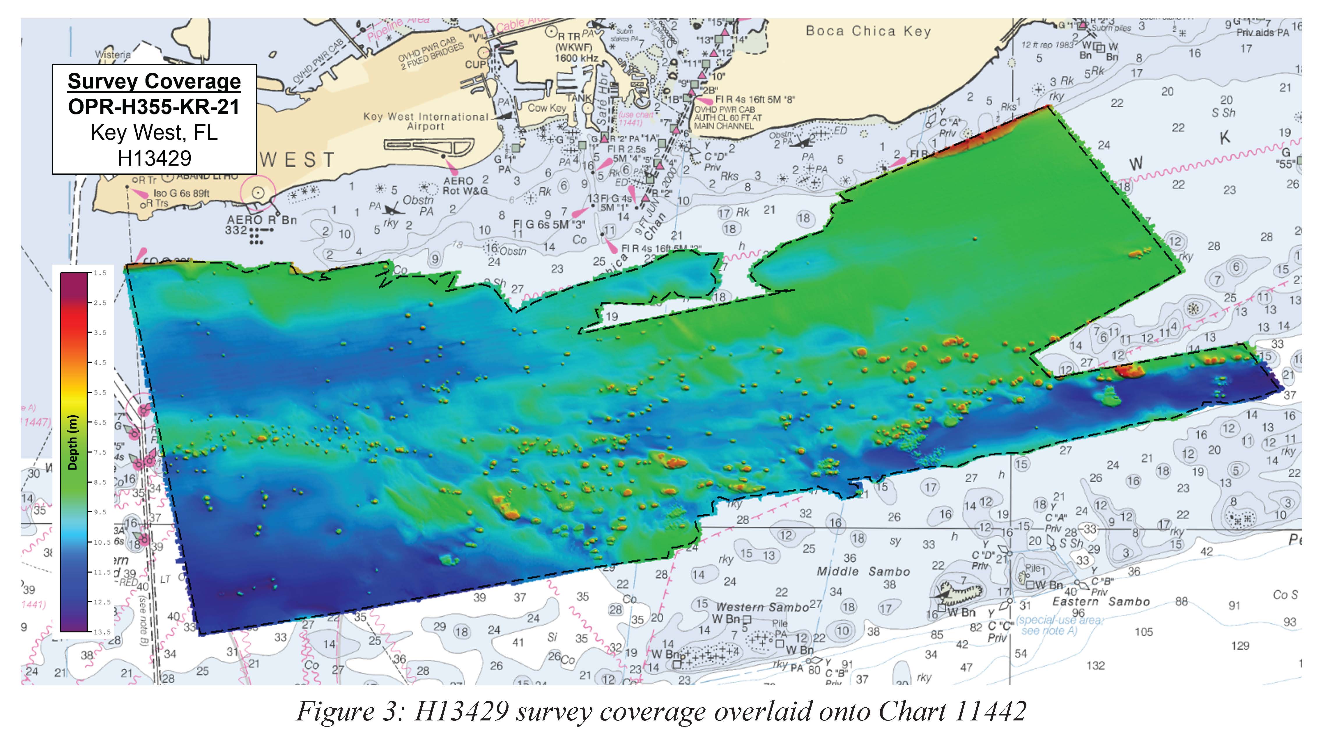
H13429: NOS Hydrographic Survey , 2021-06-23
National Oceanic and Atmospheric Administration, Department of Commerce —
The National Oceanic and Atmospheric Administration (NOAA) has the statutory mandate to collect hydrographic data in support of nautical chart compilation for safe... -
Federal
TIGER/Line Shapefile, 2022, County, Johnson County, NE, Linear Hydrography
U.S. Census Bureau, Department of Commerce —
The TIGER/Line shapefiles and related database files (.dbf) are an extract of selected geographic and cartographic information from the U.S. Census Bureau's Master... -
Federal
TIGER/Line Shapefile, 2022, State, Massachusetts, MA, State Legislative District (SLD) Lower Chamber
U.S. Census Bureau, Department of Commerce —
The TIGER/Line shapefiles and related database files (.dbf) are an extract of selected geographic and cartographic information from the U.S. Census Bureau's Master... -
Federal
Utah FORGE: Triaxial Direct Shear Results
Department of Energy —
This submission contains a report and associated data from triaxial direct shear tests conducted by Los Alamos National Laboratory. The samples used were sourced from... -
Federal
TIGER/Line Shapefile, 2022, County, Denver County, CO, Address Range-Feature
U.S. Census Bureau, Department of Commerce —
The TIGER/Line shapefiles and related database files (.dbf) are an extract of selected geographic and cartographic information from the U.S. Census Bureau's Master... -
Maryland Area Regional Commuter Routes
District of Columbia —
Maryland Transit Routes -
Federal
TIGER/Line Shapefile, 2022, County, Kauai County, HI, Feature Names Relationship File
U.S. Census Bureau, Department of Commerce —
The TIGER/Line shapefiles and related database files (.dbf) are an extract of selected geographic and cartographic information from the U.S. Census Bureau's Master...

Official websites use .gov
A
.gov website belongs to an official government
organization in the United States.
Secure .gov websites use HTTPS
A
lock (
) or https:// means you’ve safely connected to
the .gov website. Share sensitive information only on official,
secure websites.