
-
Federal
Shear-wave velocity in the Seattle basin to 2 km depth characterized with the krSPAC microtremor array method: insights for urban basin-scale imaging - Data Release
Department of the Interior —
The dataset for this investigation consists of microtremor array data collected at 11 sites in the Seattle basin, Washington State. Ten of the arrays consisted of... -
Federal
Mont Carlo Simulation Program from the World Petroleum Assessment 2000, DDS-60 (emcee.xls).xml
Department of the Interior —
Monte Carlo programs described in chapter MC, Monte Carlo Simulation Method. Emc2.xls was the program used to calculate the estimates of undiscovered resources for... -
Federal
GPM GROUND VALIDATION ENVIRONMENT CANADA (EC) PASSIVE MICROWAVE RADIOMETER AND SOIL MOISTURE-TEMPERATURE DATA GCPEX V1
National Aeronautics and Space Administration —
The GPM Ground Validation Environment Canada (EC) Passive Microwave Radiometer and Soil Moisture-Temperature Data GCPEx dataset is consisted of data during the GPM... -
Federal
GPM GROUND VALIDATION DC-8 CAMERA NADIR GCPEX V1
National Aeronautics and Space Administration —
The GPM Ground Validation DC-8 Camera Nadir GCPEx dataset contains geo-located, visible-wavelength imagery of the ground obtained from the nadir camera aboard the... -
Federal
2014 Environmental Performance Index (EPI)
National Aeronautics and Space Administration —
The 2014 Environmental Performance Index (EPI) ranks 178 countries on 20 performance indicators in the following 9 policy categories: health impacts, air quality,... -
Federal
Soil Moisture Active Passive (SMAP) L4 Soil Moisture Ancillary Catchment Model Tile Space V001
National Aeronautics and Space Administration —
This ancillary SMAP product contains tile information for the NASA Land Data Assimilation System (LDAS) Catchment model, including center-of-mass latitude/longitude,... -
Federal
Chalk Cliffs Channel Surveys derived from Structure-from-Motion
Department of the Interior —
This data release contains two point clouds derived from structure-from-motion photogrammetry. The first survey was conducted on 10 September 2015 and the second... -
Federal
VIIRS/JPSS1 FILDA-2 Fire Modified Combustion Efficiency Product 6-min L2 Swath 750m V002
National Aeronautics and Space Administration —
The Visible Infrared Imaging Radiometer Suite (VIIRS) FIre Light Detection Algorithm-2 (FILDA-2) Modified Combustion Efficiency (MCE) Version 2 swath product... -
Federal
SnowEx20-21 QSI Lidar Vegetation Height 3m UTM Grid V001
National Aeronautics and Space Administration —
This data set is part of the SnowEx 2020 and SnowEx 2021 campaigns and provides vegetation height values at a 3.0 m spatial resolution, derived from point cloud... -
Federal
Aqua MODIS Regional Normalized Difference Vegetation Index Land Reflectance Data, version R2022.0 NGDA
National Aeronautics and Space Administration —
MODIS (or Moderate-Resolution Imaging Spectroradiometer) is a key instrument aboard the Terra (EOS AM) and Aqua (EOS PM) satellites. Terra's orbit around the Earth is... -
Federal
National Assessment of Oil and Gas Project - Eastern Great Basin Province (019) Total Petroleum Systems
Department of the Interior —
The Total Petroleum System is used in the National Assessment Project and incorporates the Assessment Unit, which is the fundamental geologic unit used for the... -
Federal
National Assessment of Oil and Gas Project - Illinois Basin Province (064) Assessment Units
Department of the Interior —
The Assessment Unit is the fundamental unit used in the National Assessment Project for the assessment of undiscovered oil and gas resources. The Assessment Unit is... -
Federal
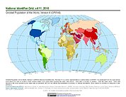
Gridded Population of the World, Version 4 (GPWv4): National Identifier Grid, Revision 11
National Aeronautics and Space Administration —
The Gridded Population of the World, Version 4 (GPWv4): National Identifier Grid, Revision 11 is a raster representation of nation-states in GPWv4 for use in... -
Federal
SnowEx20 Raw Near Surface Snow Temperature Profile Time Series V001
National Aeronautics and Space Administration —
This data set contains an eight-day time series of vertical temperature profile measurements. Measurements were collected using a thermoprobe to a depth of 30 cm at... -
Federal
SMAP L1C Radiometer Half-Orbit 36 km EASE-Grid Brightness Temperatures V006
National Aeronautics and Space Administration —
This Level-1C (L1C) product contains calibrated and geolocated brightness temperatures acquired by the Soil Moisture Active Passive (SMAP) radiometer during 6:00 a.m.... -
Federal
Aqua MODIS Global Mapped Normalized Difference Vegetation Index Land Reflectance Data, version R2022.0 NGDA
National Aeronautics and Space Administration —
MODIS (or Moderate-Resolution Imaging Spectroradiometer) is a key instrument aboard the Terra (EOS AM) and Aqua (EOS PM) satellites. Terra's orbit around the Earth is... -
Federal
Tri-Decadal Global Landsat Orthorectified MSS 1-5 Single Scene: 1972-1987
Department of the Interior —
'The USGS Earth Resources Observation and Science (EROS) Center archive holds data collected by the Landsat suite of satellites, beginning with Landsat 1 in 1972. All... -
Federal
National Assessment of Oil and Gas - Cotton Valley Group and Travis Peak-Hosston Formation Assessment Units, Western Gulf and East Texas Basin and Louisiana-Mississippi Salt Basins Provinces (047, 048 and 049)
Department of the Interior —
The Assessment Unit is the fundamental unit used in the National Assessment Project for the assessment of undiscovered oil and gas resources. The Assessment Unit is... -
Federal
MODIS/Aqua Sea Ice Extent Daily L3 Global 1km EASE-Grid Day V061 NGDA
National Aeronautics and Space Administration —
This global Level-3 (L3) data set provides daily daytime sea ice extent and ice surface temperature derived from the 'MODIS/Aqua Sea Ice Extent 5-Min L2 Swath 1km'... -
Federal
National Assessment of Oil and Gas Project - Uinta-Piceance Province (020) Estimated Depth to the Base of the Mesaverde Total Petroleum System
Department of the Interior —
This dataset shows estimated depth ranges to stratigraphic horizons near the base of the Mesaverde Total Petroleum System, Uinta-Piceance Province, northwestern...

Official websites use .gov
A
.gov website belongs to an official government
organization in the United States.
Secure .gov websites use HTTPS
A
lock (
) or https:// means you’ve safely connected to
the .gov website. Share sensitive information only on official,
secure websites.