
-
Federal
2015 NOAA NGS Topobathy Lidar: Puerto Rico recent views
National Oceanic and Atmospheric Administration, Department of Commerce —
These data were collected by the National Oceanic Atmospheric Administration National Geodetic Survey Remote Sensing Division using a Riegl VQ-820G system. The data... -
Federal
2014 NOAA NGS Topobathy Lidar: St Croix (USVI) recent views
National Oceanic and Atmospheric Administration, Department of Commerce —
These data were collected by the National Oceanic Atmospheric Administration National Geodetic Survey Remote Sensing Division using a Riegl VQ820G system. The data... -
Federal
2019 NOAA NGS Topobathy Lidar: U.S. Virgin Islands recent views
National Oceanic and Atmospheric Administration, Department of Commerce —
These data were collected by Leading Edge Geomatics using a Riegl VQ-880-G II sensor. The data acqusition began January 20, 2019 through June 2, 2019. The data... -
Federal
2019 NOAA NGS Topobathy Lidar DEM: U.S. Virgin Islands recent views
National Oceanic and Atmospheric Administration, Department of Commerce —
These data were collected by Leading Edge Geomatics using a Riegl VQ-880-G II sensor. The data acqusition began January 20, 2019 through June 2, 2019. The data... -
Federal
2019 NOAA NGS Topobathy Lidar DEM: Puerto Rico recent views
National Oceanic and Atmospheric Administration, Department of Commerce —
These data were collected by Leading Edge Geomatics using a Riegl VQ-880-G II sensor. The data acqusition began January 20, 2019 through June 2, 2019. The data... -
Federal
EAARL-B Submerged Topography - Saint Croix and Saint Thomas, U.S. Virgin Islands, 2014 recent views
National Oceanic and Atmospheric Administration, Department of Commerce —
Binary point-cloud data for part of the submerged environs of Saint Croix and Saint Thomas, U.S. Virgin Islands, were produced from remotely sensed, geographically... -
Federal
H08849: NOS Hydrographic Survey , Ensenada Honda, Puerto Rico, 1965-05-17 recent views
National Oceanic and Atmospheric Administration, Department of Commerce —
The National Oceanic and Atmospheric Administration (NOAA) has the statutory mandate to collect hydrographic data in support of nautical chart compilation for safe... -
Federal
NOAA ESRI Geotiff - 3m Multibeam Bathymetry, Puerto Rico (Tourmaline Bank) - Project NF-08-04, , UTM 19N NAD83 recent views
National Oceanic and Atmospheric Administration, Department of Commerce —
This dataset contains an ESRI Geotiff with 3 meter cell size representing the bathymetry of selected portions of seafloor around Tourmaline Bank in Puerto Rico,... -
Federal
H02920B: NOS Hydrographic Survey recent views
National Oceanic and Atmospheric Administration, Department of Commerce —
The National Oceanic and Atmospheric Administration (NOAA) has the statutory mandate to collect hydrographic data in support of nautical chart compilation for safe... -
Federal
Charlotte Amalie, Virgin Islands Tsunami Forecast Grids for MOST Model recent views
National Oceanic and Atmospheric Administration, Department of Commerce —
The Charlotte Amalie, Virgin Islands Forecast Model Grids provides bathymetric data strictly for tsunami inundation modeling with the Method of Splitting Tsunami... -
Federal
H09595: NOS Hydrographic Survey , Off Punta Candelero, Puerto Rico, 1976-04-17 recent views
National Oceanic and Atmospheric Administration, Department of Commerce —
The National Oceanic and Atmospheric Administration (NOAA) has the statutory mandate to collect hydrographic data in support of nautical chart compilation for safe... -
Federal
Puerto Rico: Continuously Updated Digital Elevation Model (CUDEM) - 1/9 Arc-Second Resolution Bathymetric-Topographic Tiles recent views
National Oceanic and Atmospheric Administration, Department of Commerce —
NOAA's National Centers for Environmental Information (NCEI) is developing a suite of digital elevation models (DEMs) for the U.S. coast to support a variety of NOAA... -
Federal
Puerto Rico: Continuously Updated Digital Elevation Model (CUDEM) - 1/3 Arc-Second Resolution Bathymetric-Topographic Tiles recent views
National Oceanic and Atmospheric Administration, Department of Commerce —
NOAA's National Centers for Environmental Information (NCEI) is developing a suite of digital elevation models (DEMs) for the U.S. coast to support a variety of NOAA... -
Federal
St. Thomas and St. John, U.S. Virgin Islands 1/3 arc-second MHW Coastal Digital Elevation Model recent views
National Oceanic and Atmospheric Administration, Department of Commerce —
The 1/3 arc-second St. Thomas and St. John, U.S. Virgin Islands Coastal Digital Elevation Model will be used to support NOAA's tsunami forecast system and for tsunami... -
Federal
NEPR World View 2 Satellite Mosaic - NOAA TIFF Image recent views
National Oceanic and Atmospheric Administration, Department of Commerce —
This GeoTiff is a mosaic of World View 2 panchromatic satellite imagery of Northeast Puerto Rico that contains the shallow water area (0-35m deep) surrounding... -
Federal
2019 NOAA NGS Topobathy Lidar: Puerto Rico recent views
National Oceanic and Atmospheric Administration, Department of Commerce —
These data were collected by Leading Edge Geomatics using a Riegl VQ-880-G II sensor. The data acqusition began January 20, 2019 through June 2, 2019. The data... -
Federal
San Juan, Puerto Rico Coastal Digital Elevation Model recent views
National Oceanic and Atmospheric Administration, Department of Commerce —
NOAA's National Geophysical Data Center (NGDC) is building high-resolution digital elevation models (DEMs) for select U.S. coastal regions. These integrated... -
Federal
F00761: NOS Hydrographic Survey , 2018-10-25 recent views
National Oceanic and Atmospheric Administration, Department of Commerce —
The National Oceanic and Atmospheric Administration (NOAA) has the statutory mandate to collect hydrographic data in support of nautical chart compilation for safe... -
Federal
F00708: NOS Hydrographic Survey , 2017-10-06 recent views
National Oceanic and Atmospheric Administration, Department of Commerce —
The National Oceanic and Atmospheric Administration (NOAA) has the statutory mandate to collect hydrographic data in support of nautical chart compilation for safe... -
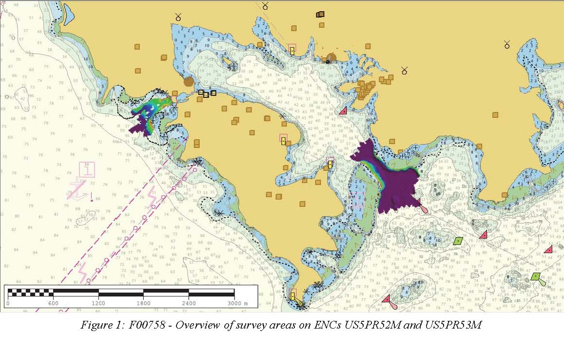
Federal
F00758: NOS Hydrographic Survey , 2018-10-30 recent views
National Oceanic and Atmospheric Administration, Department of Commerce —
The National Oceanic and Atmospheric Administration (NOAA) has the statutory mandate to collect hydrographic data in support of nautical chart compilation for safe...

Official websites use .gov
A
.gov website belongs to an official government
organization in the United States.
Secure .gov websites use HTTPS
A
lock (
) or https:// means you’ve safely connected to
the .gov website. Share sensitive information only on official,
secure websites.