
-
Federal
Low-Mass X-Ray Binary Catalog (4th Edition, 2007)
National Aeronautics and Space Administration —
This is the Fourth Edition of the Catalog of Low-mass X-ray Binaries (LMXBs) in the Galaxy and the Magellanic Clouds. The catalog has a companion catalog of high-mass... -
Federal
AKARI NEP WSRT 20-cm Source Catalog
National Aeronautics and Space Administration —
The Westerbork Radio Synthesis Telescope (WSRT) has been used in 2004 to make a deep radio survey of an ~1.7 degree2 field coinciding with the AKARI north ecliptic... -
Federal
South Pole Telescope 87-Square Degree Survey Millimeter Source Catalog
National Aeronautics and Space Administration —
This table contains the results of an 87 deg2 point-source survey centered at RA = 5h30m, Dec = -55o (J2000.0) taken with the South Pole Telescope at 1.4 and 2.0 mm... -
Federal
Master EUV Catalog
National Aeronautics and Space Administration —
The EUV database table is the Extreme Ultraviolet (EUV) Master Catalog and contains a compendium of EUV sources. It is comprised of selected fields from the following... -
Federal
AKARI/FIS All-Sky Survey Bright Source Catalog, Version 1
National Aeronautics and Space Administration —
The AKARI Infrared Astronomical Satellite observed the whole sky in the far-infrared (50-180 microns or um) and the mid-infrared (9 and 18 um) between May 2006 and... -
Federal
Dissolved inorganic carbon, total alkalinity, pH on total scale, and other variables collected from profile and discrete sample observations using CTD, Niskin bottle, and other instruments from NOAA Ship Ronald H. Brown in the U.S. West Coast California Current System from 2016-05-08 to 2016-06-06 (NCEI Accession 0169412)
National Oceanic and Atmospheric Administration, Department of Commerce —
This dataset contains the discrete carbon data collected during the 2016 West Coast Ocean Acidification (WCOA) cruise. WCOA2016 took place May 5 to June 7, 2016... -
Federal
unit_595-20170713T1730-delayed
National Oceanic and Atmospheric Administration, Department of Commerce —
Shipboard observations of marine mammal distribution and habitat are expensive and logistically challenging to collect in Arctic waters. Port facilities are minimal... -
Federal
Compendium Child Welfare
U.S. Department of Health & Human Services —
Child Welfare Training Grant funds are authorized each fiscal year for grants to public or other non-profit institutions of higher learning for special projects to... -
Federal
Utah FORGE 2-2439v2: Report on Predicting Far-Field Stresses Using Finite Element Modeling and Near-Wellbore Machine Learning for Well 16A(78)-32
Department of Energy —
This report presents the far-field stress predictions at two locations along the vertical section of Utah FORGE Well 16A (78)-32 using a physics-based thermo-poro-... -
State
Pronghorn Migration Corridors - Likely Tables - 2014-2020 [ds2934]
State of California —
The project lead for the collection of this data was Richard Shinn. Pronghorn (30 adult females and 1 adult male) were captured and equipped with GPS collars... -
Federal
SAFARI 2000 FEWS 10-day Rainfall Estimate, 8-Km, 1999-2001
National Aeronautics and Space Administration —
The U.S. Agency for International Development (USAID) Famine Early Warning System (FEWS) has been supporting the production of 10-day Rainfall Estimate (RFE) data for... -
Federal
Polar Radiant Energy in the Far InfraRed Experiment (PREFIRE) Surface Emissivity Sorted All-sky Climatology from PREFIRE Satellite 1 R01
National Aeronautics and Space Administration —
Polar Radiant Energy in the Far InfraRed Experiment (PREFIRE) Surface Emissivity Sorted All-sky Climatology from PREFIRE Satellite 1 (PREFIRE_SAT1_3-SFC-... -
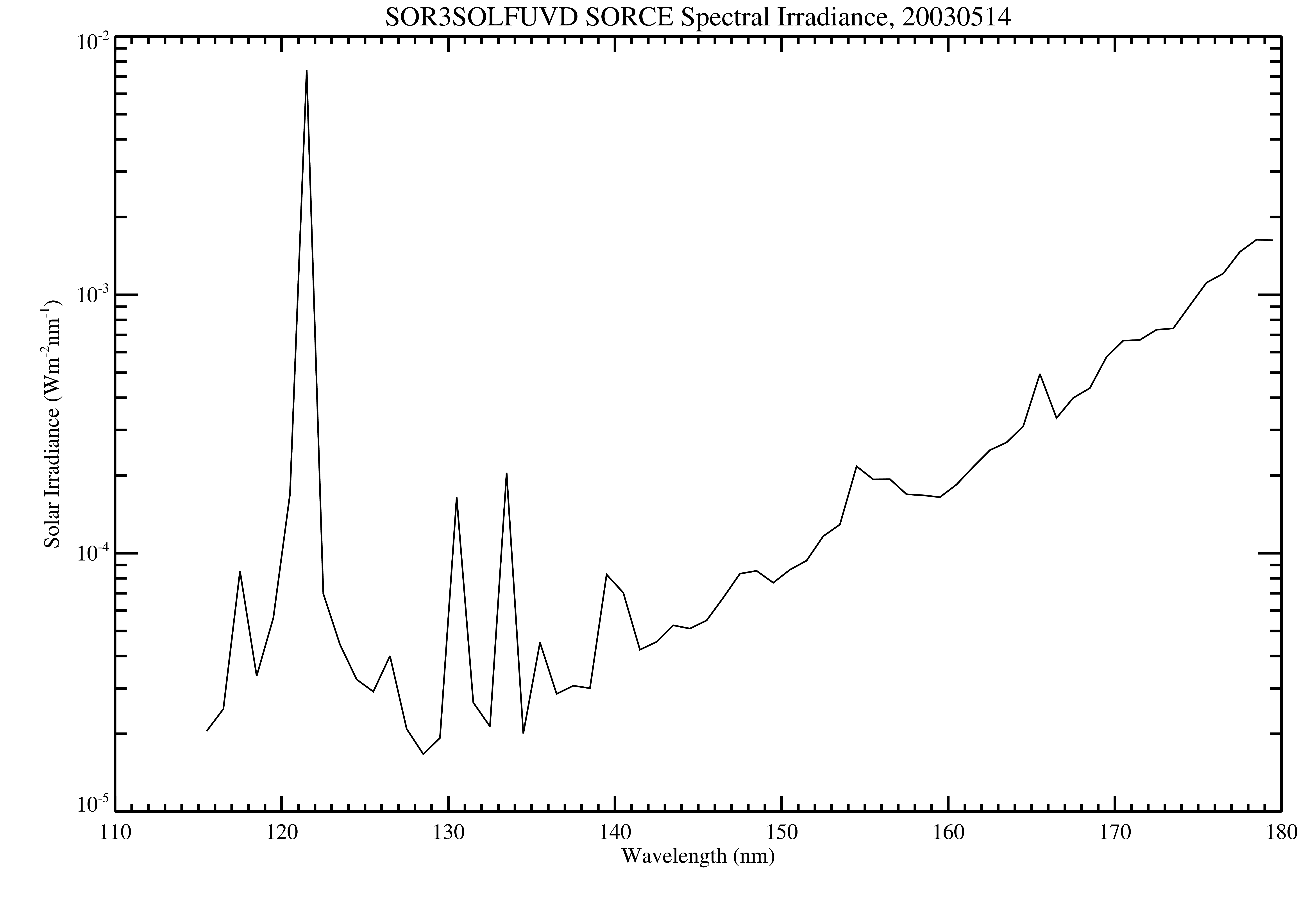
Federal
SORCE SOLSTICE FUV Level 3 Solar Spectral Irradiance Daily Means V018 (SOR3SOLFUVD) at GES DISC
National Aeronautics and Space Administration —
Version 018 is the final version of this data product, and supersedes all previous versions. The SORCE SOLSTICE Far-UV Solar Spectral Irradiance (SSI) data product... -
Federal
RLC AVHRR-Derived Land Cover, Former Soviet Union, Far East, 1-km, 1990
National Aeronautics and Space Administration —
This data set is a 1-kilometer resolution land cover map for the land area of the Primor'ye and Southern Khabarovsk Regions, in the Russian Far East, based on 1990... -
Federal
LMOS Zion Ground Site Data
National Aeronautics and Space Administration —
LMOS_Ground_Zion_Data_1 is the Lake Michigan Ozone Study (LMOS) data collected at the Zion ground site during the LMOS field campaign. This product is a result of a... -
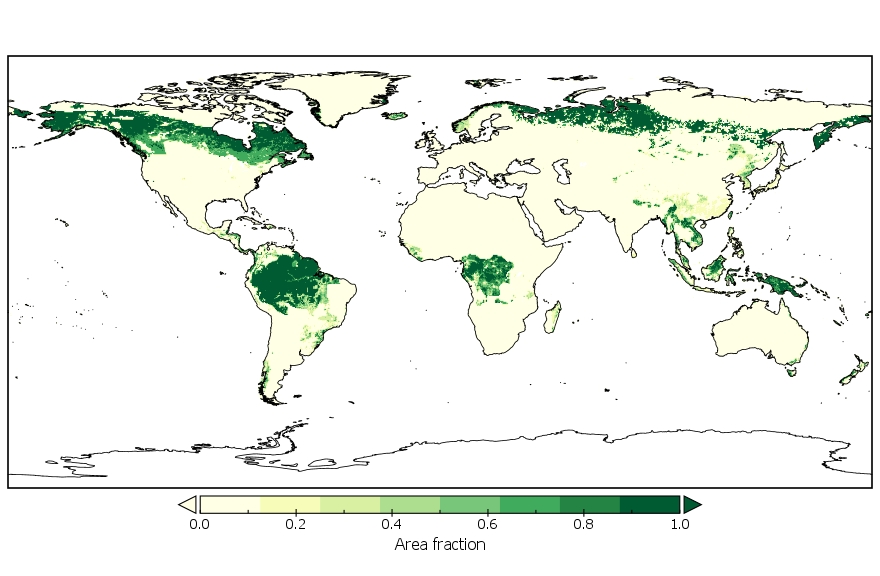
Federal
LUH2-GCB2019: Land-Use Harmonization 2 Update for the Global Carbon Budget, 850-2019
National Aeronautics and Space Administration —
This dataset, referred to as LUH2-GCB2019, includes 0.25-degree gridded, global maps of fractional land-use states, transitions, and management practices for the... -
Federal
LMOS Wisconsin Department of Natural Resources (WDNR) Routine Ground Site Data
National Aeronautics and Space Administration —
LMOS_Ground_WDNRRoutine_Data_1 is the Lake Michigan Ozone Study (LMOS) ground site data collected at the Wisconsin Department of Natural Resources (WDNR) Routine... -
Federal
LMOS Sheboygan Ground Site Data
National Aeronautics and Space Administration —
LMOS_Ground_Sheboygan_Data_1 is the Lake Michigan Ozone Study (LMOS) is Sheboygan ground site data collected during the LMOS field campaign. This product is a result... -
Federal
LMOS Surface Mobile EPA-GMAP Ozone Data
National Aeronautics and Space Administration —
LMOS_TraceGas_SurfaceMobile_EPA-GMAP_Data_1 is the Lake Michigan Ozone Study (LMOS) trace gas surface mobile data collected via the Environmental Protection Agency... -
Federal
NCEP/CPC L3 Half Hourly 4km Global (60S - 60N) Merged IR V1 (GPM_MERGIR) at GES DISC
National Aeronautics and Space Administration —
These data originate from NOAA/NCEP. The NOAA Climate Prediction Center/NCEP/NWS is making the data available originally in binary format, in a weekly rotating...

Official websites use .gov
A
.gov website belongs to an official government
organization in the United States.
Secure .gov websites use HTTPS
A
lock (
) or https:// means you’ve safely connected to
the .gov website. Share sensitive information only on official,
secure websites.