
-
Federal
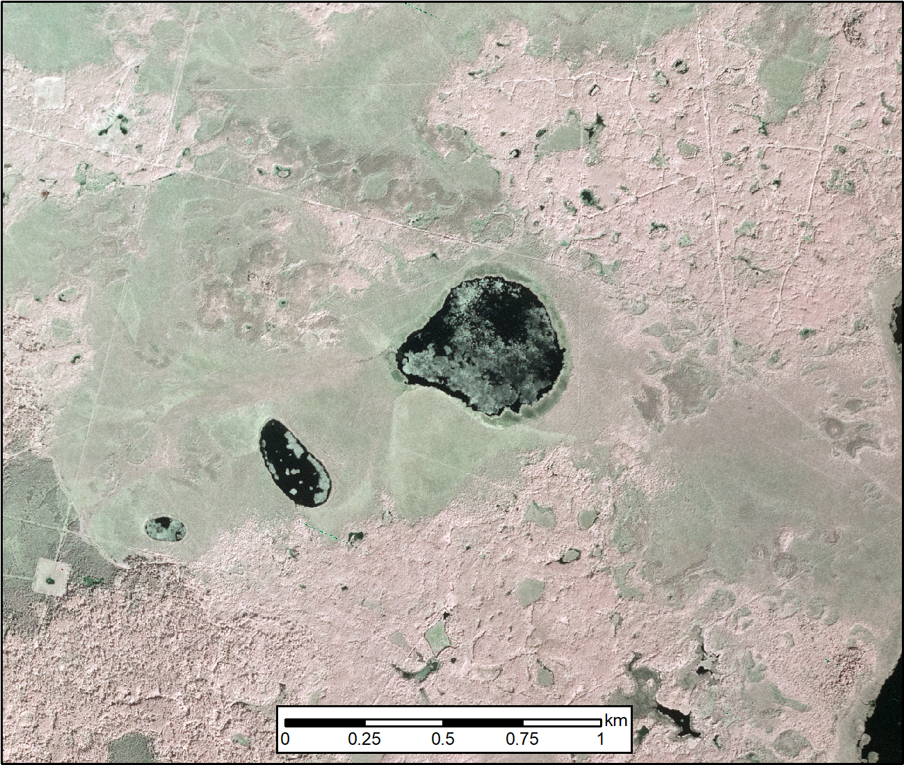
ABoVE: AirSWOT Color-Infrared Imagery Over Alaska and Canada, 2017
National Aeronautics and Space Administration —
This dataset contains georeferenced three-band orthomosaics of green, red, and near-infrared (NIR) digital imagery at 1m resolution collected over selected surface... -
Federal
BOREAS RSS-20 POLDER C-130 Measurements of Surface BRDF
National Aeronautics and Space Administration —
This data set contains measurements of surface BRDF made by the POLDER instrument over several surface types (pine, spruce, fen) of the BOREAS SSA during the 1994... -
Federal
BOREAS RSS-16 Level-3b DC-8 AIRSAR SY Images
National Aeronautics and Space Administration —
The BOREAS RSS-16 team used satellite and aircraft SAR data in conjunction with various ground measurements to determine the moisture regime of the boreal forest.... -
Federal
Atmos. Profile: Radiosonde - NCDC (FIFE)
National Aeronautics and Space Administration —
The NOAA Radiosonde Observations - 1989 (NCDC) Data Set contains radiosonde data obtained from the National Climatic Data Center (NCDC). These 396 days of data cover... -
Federal
BOREAS RSS-08 BIOME-BGC Model Simulations at Tower Flux Sites in 1994
National Aeronautics and Space Administration —
BIOME-BGC is a general ecosystem process model designed to simulate biogeochemical and hydrologic processes across multiple scales (Running and Hunt, 1993). In this... -
Federal
BOREAS RSS-07 LAI, Gap Fraction, and FPAR Data
National Aeronautics and Space Administration —
The BOREAS RSS-07 team collected various data sets to develop and validate an algorithm to allow the retrieval of the spatial distribution of LAI from remotely sensed... -
Federal
BOREAS RSS-04 1994 Southern Study Area Jack Pine LAI & FPAR Data
National Aeronautics and Space Administration —
The RSS-04 team collected several data sets related to leaf, plant, and stand physical, optical, and chemical properties. This data set contains leaf area indices and... -
Federal
BOREAS TE-09 Leaf Biochemistry Point Data
National Aeronautics and Space Administration —
The BOREAS TE-09 team collected several data sets related to chemical and photosynthetic properties of leaves. This data set contains canopy biochemistry data... -
Federal
Carbon Monitoring System Carbon Flux NBE L4 V3 (CMSFluxNBE)
National Aeronautics and Space Administration —
This dataset provides the Carbon Flux for Posterior Net Biome Exchange (NBE).The NASA Carbon Monitoring System (CMS) is designed to make significant contributions in... -
Federal
BOREAS TF-02 SSA-OA Tower Flux, Meteorological, and Precipitation Data
National Aeronautics and Space Administration —
The BOREAS TF-02 team collected energy, carbon dioxide, water vapor, and momentum flux data above the canopy and in profiles through the canopy, along with... -
Federal
BOREAS TF-01 SSA-OA Soil Characteristics Data
National Aeronautics and Space Administration —
The BOREAS TF-01 team collected several data sets in support of its efforts to characterize and interpret soil information at the SSA-OA tower site in 1994 as part of... -
Federal
BOREAS AFM-05 Level-2 Upper Air Network Standard Pressure Level Data
National Aeronautics and Space Administration —
The BOREAS AFM-05 team collected and processed data from the numerous radiosonde flights during the project. The goals of the AFM-05 team were to provide large scale... -
Federal
CMS: Mangrove Canopy Height from High-resolution Stereo Image Pairs, Mozambique, 2012
National Aeronautics and Space Administration —
This data set provides canopy height estimates for mangrove forests at 0.6 x 0.6 m resolution in three study sites located in southeastern Mozambique, Africa: two... -
Federal
CMS: Mangrove Canopy Characteristics and Land Cover Change, Tanzania, 1990-2014
National Aeronautics and Space Administration —
This data set provides canopy height, land cover change, and stand age estimates for mangrove forests in the Rufiji River Delta in Tanzania. The estimates were... -
Federal
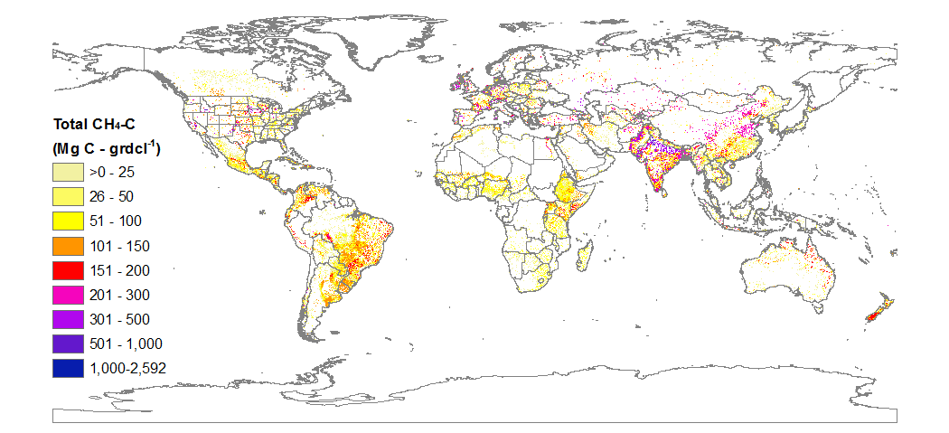
BOREAS TGB-05 CO2, CH4, and CO Chamber Flux Data over the NSA
National Aeronautics and Space Administration —
The BOREAS TGB-05 team collected a variety of trace gas concentration and flux measurements at several NSA sites. This data set contains carbon dioxide (CO2), methane... -
Federal
BOREAS Daedalus TMS Level-0 Imagery: Digital Counts in BIL Format
National Aeronautics and Space Administration —
The level-0 Daedalus TMS imagery, along with the other remotely sensed images, was collected to provide spatially extensive information about radiant energy over the... -
Federal
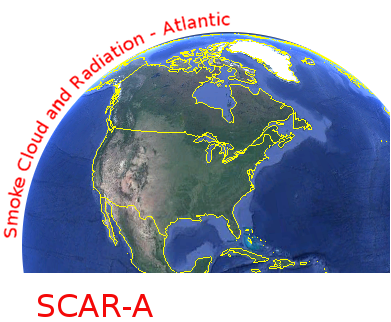
CAR SCAR-A Sulfates, Clouds, and Radiation-Atlantic L1 V1 (CAR_SCARA_L1C) at GES DISC
National Aeronautics and Space Administration —
The objectives for the SCAR mission are to advance our knowledge of how the physical, chemical and radiative processes in our atmosphere are affected by sulfate... -
Federal
BOREAS Landsat TM Level-3b Imagery: At-Sensor Radiance in BSQ Format
National Aeronautics and Space Administration —
For BOREAS, the level-3b Landsat TM data, along with the other remotely sensed images, were collected in order to provide spatially extensive information over the...

Official websites use .gov
A
.gov website belongs to an official government
organization in the United States.
Secure .gov websites use HTTPS
A
lock (
) or https:// means you’ve safely connected to
the .gov website. Share sensitive information only on official,
secure websites.