
-
Federal
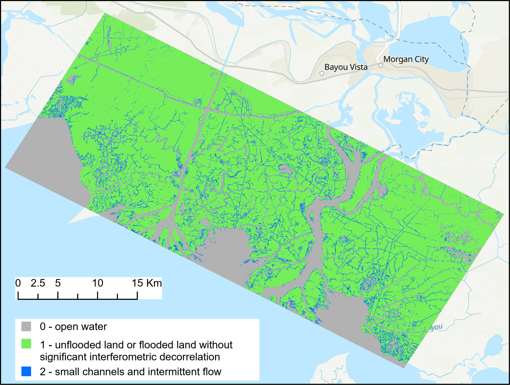
Pre-Delta-X: UAVSAR Georeferenced Channel Maps, Atchafalaya Basin, LA, USA, 2016, V2
National Aeronautics and Space Administration —
This dataset provides spatial data on water channels in the estuary of the Atchafalaya Basin of the Mississippi River Delta of coastal Louisiana. These Level-3 (L3)... -
Federal
SAFARI 2000 Vegetation Structure of Kataba Forest, Zambia, Wet Season 2000
National Aeronautics and Space Administration —
Tree basal area, percent tree canopy cover, and proportional contribution of main species to canopy cover were measured at 60 sampling points at 50 m intervals along... -
Federal
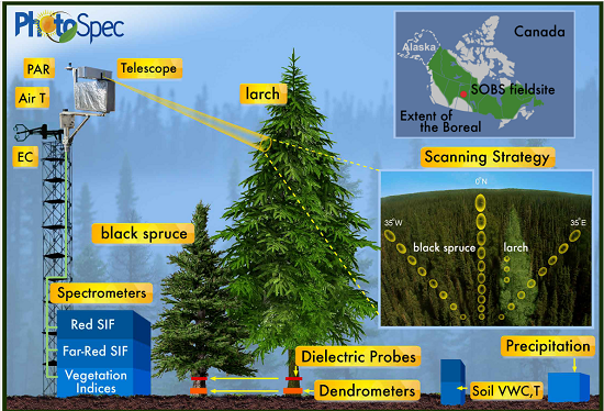
Tower-based PhotoSpec Products for the 2019 and 2020 Spring Transition Season, SK, CA
National Aeronautics and Space Administration —
This dataset includes daily averaged solar-induced chlorophyll fluorescence (SIF) in the red (680-686 nm) and far-red (745-758 nm) wavelength ranges, relative SIF... -
Federal
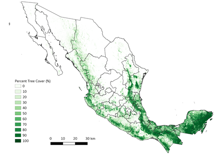
Tree Cover Estimates at 30 m Resolution for Mexico, 2016-2018
National Aeronautics and Space Administration —
The data set provides multi-year (2016-2018) percent tree cover (TC) estimates for entire Mexico at 30 m spatial resolution. The TC data (hereafter, NEX-TC) was... -
Federal
Forest-BGC Model (OTTER)
National Aeronautics and Space Administration —
Steve Running's Forest-BGC Model -
Federal
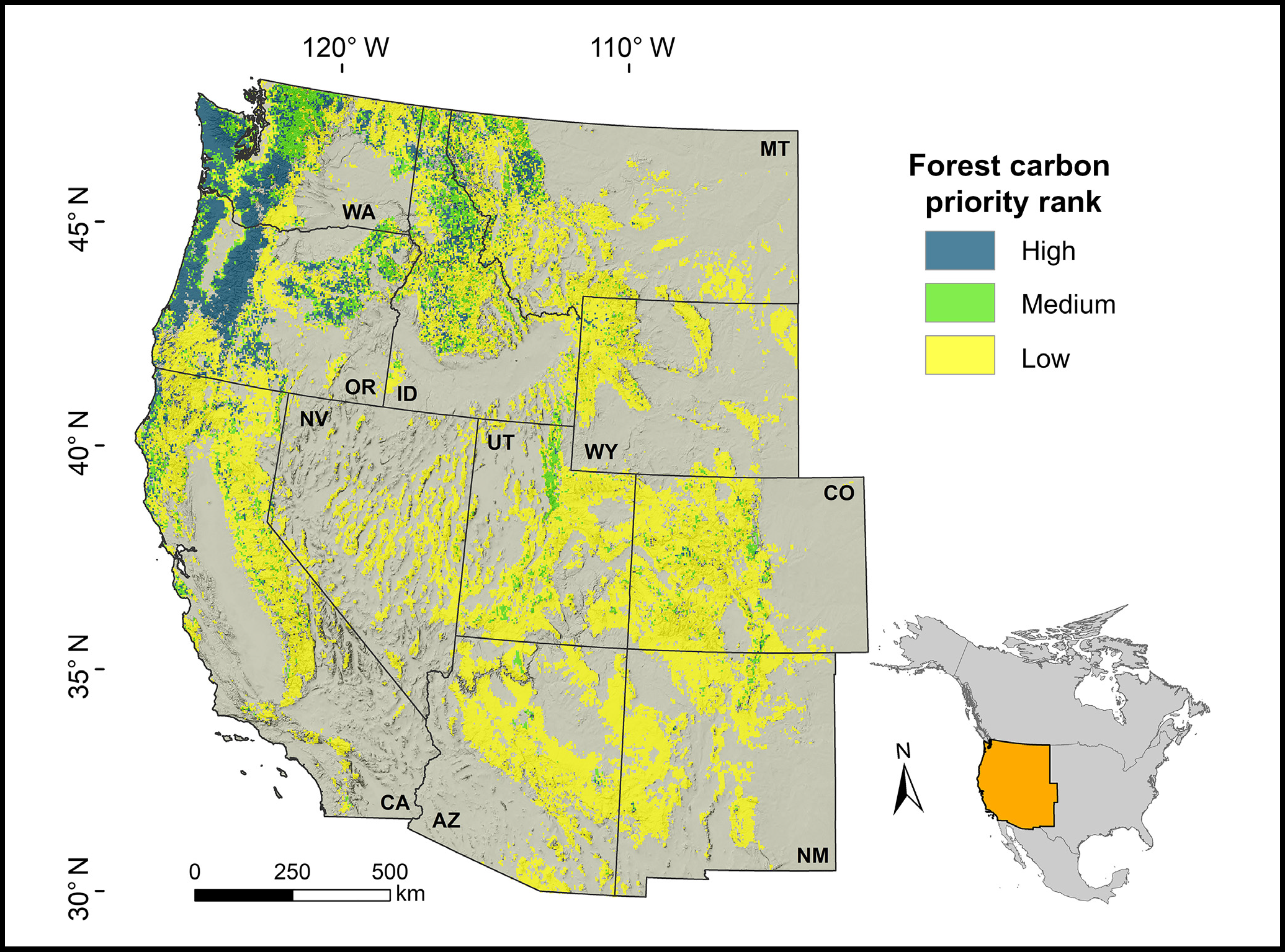
Forest Preservation Ranking and Vertebrate Species Richness, Western USA, 2020-2099
National Aeronautics and Space Administration —
This dataset provides related gridded outputs of future modeled forest carbon sequestration priority and related species richness and habitat suitability for the... -
Federal
Sediment Grab Data from September 2001 in Wells, Maine (wellssedgrabs)
National Oceanic and Atmospheric Administration, Department of Commerce —
In fall 2001, researchers from the Wells National Estuarine Research Reserve, Virginia Institute of Marine Science, and the NOAA Office for Coastal Management... -
Federal
Benthic Habitats of Florida Bay, FL 1991-1995 Biotic
National Oceanic and Atmospheric Administration, Department of Commerce —
In the winter of 1991/92 the National Oceanic and Atmospheric Administration's Office for Coastal Management's Coastal Change Analysis Program (C-CAP) and the State... -
Federal
Fire Intensity and Burn Severity Metrics for Circumpolar Boreal Forests, 2001-2013
National Aeronautics and Space Administration —
This data set provides products characterizing immediate and longer-term ecosystem changes from fires in the circumpolar boreal forests of Northern Eurasia and North... -
Federal
CMS: LiDAR-derived Estimates of Aboveground Biomass at Four Forested Sites, USA
National Aeronautics and Space Administration —
These data consist of high-resolution maps of aboveground biomass at four forested sites in the US: Garcia River Tract in California, Anne Arundel and Howard Counties... -
Federal
Delta-X: Real-Time Kinematic Elevation Measurements for Coastal Wetlands, LA, 2021
National Aeronautics and Space Administration —
This dataset provides real-time kinematic (RTK) GPS elevation measurements, along with horizontal and vertical precision errors, obtained along transects near... -
Federal
ISLSCP II Sea Surface Temperature
National Aeronautics and Space Administration —
Sea surface temperature (SST) is an important indicator of the state of the earth climate system as well as a key variable in the coupling between the atmosphere and... -
Federal
LBA-ECO ND-02 Soil Volumetric Water Content, Tapajos National Forest, Brazil
National Aeronautics and Space Administration —
This data set reports monthly measured soil volumetric water content (VWC) from a rainfall exclusion experiment that was conducted from 1999-2001 at the km 67 Seca... -
Federal
BOREAS TF-11 Decomposition Data over the SSA-Fen
National Aeronautics and Space Administration —
The BOREAS TF-11 team collected several data sets in their efforts to fully describe the flux and site characteristics at the SSA-Fen site. This data set contains... -
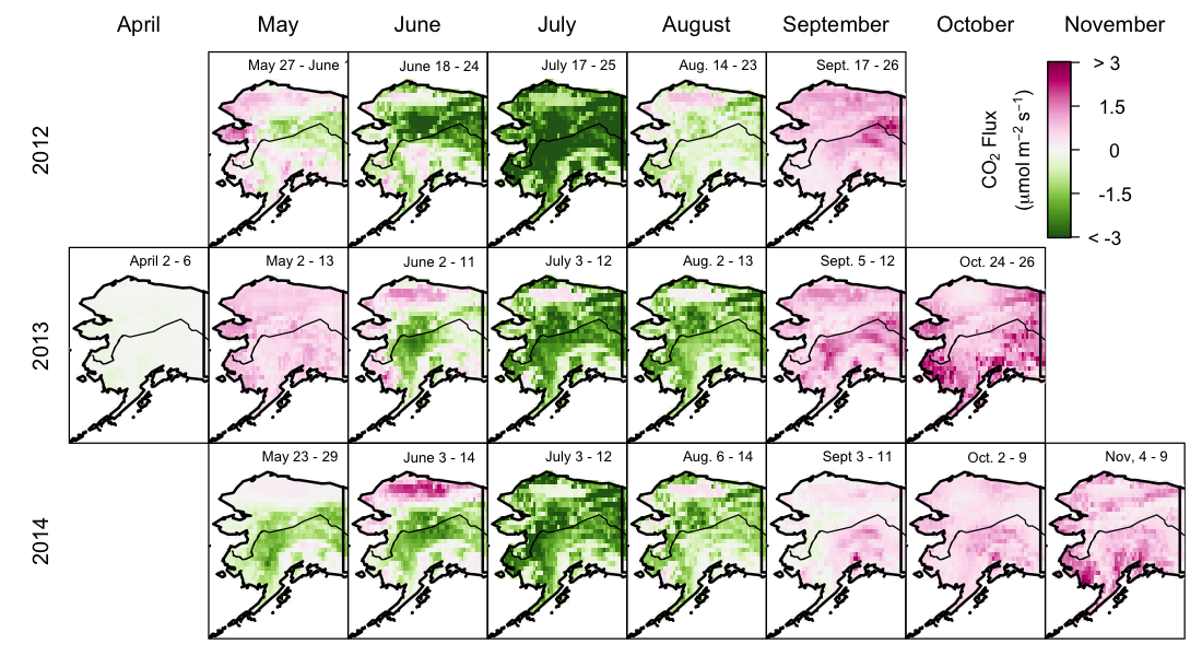
Federal
CARVE: Net Ecosystem CO2 Exchange and Regional Carbon Budgets for Alaska, 2012-2014
National Aeronautics and Space Administration —
This data set provides estimates of 3-hourly net ecosystem CO2 exchange (NEE) at 0.5-degree resolution over the state of Alaska for 2012-2014. The NEE estimates are...

Official websites use .gov
A
.gov website belongs to an official government
organization in the United States.
Secure .gov websites use HTTPS
A
lock (
) or https:// means you’ve safely connected to
the .gov website. Share sensitive information only on official,
secure websites.