
-
Federal
SWOT 2019-2020 Prelaunch Oceanography Field Campaign SIO Mooring WireWalker (WW)
National Aeronautics and Space Administration —
This dataset provides the conductivity, temperature and depth (CTD) measurements from the CTD sensors on a WireWalker profiler on a full-depth mooring deployed by the... -
Federal
Sounder SIPS: JPSS-1 CrIS Level 3 Specific Quality Control Gridded Daily CLIMCAPS V2 (SNDRJ1IML3SDCCP) at GES DISC
National Aeronautics and Space Administration —
WARNING: To users of the derived product “co_mmr_midtrop” (carbon monoxide mass mixing ratio to dry air [kg/kg] at ~500 hPa). This variable has a significant bias due... -
Federal
SOLVE I DC-8 Analysis Model Data
National Aeronautics and Space Administration —
SOLVE1_Analysis_DC8_Data contains modeled trajectories and meteorological data along the flight path for the DC-8 aircraft collected during the SAGE III Ozone Loss... -
Federal
Sentinel-6A MF Jason-CS L3 P4 Altimeter Low Resolution (LR) NTC Ocean Surface Topography (Unfiltered) Version F08
National Aeronautics and Space Administration —
Provides L3 low resolution (LR) non-time critical (NTC; 60-day latency) altimetry from the Poseidon-4 SAR altimeter on the Sentinel-6A Michael Freilich spacecraft,... -
Federal
Sentinel-6A MF Jason-CS L2 P4 Altimeter Low Resolution (LR) STC Ocean Surface Topography
National Aeronautics and Space Administration —
Provides low resolution (LR) short time critical (STC; 36-hour latency) measurements of sea surface height anomaly (SSHA), Significant Wave Height (SWH), and Wind... -
Federal
Site Averaged Neutron Soil Moisture: 1987 (Betts)
National Aeronautics and Space Administration —
The Site Averaged Neutron Soil Moisture Data: 1987 (Betts) Data Set contains the site averaged product data of the neutron probe soil moisture collected during the... -
Federal
SMEX03 QuikSCAT/SeaWinds Backscatter Data, Alabama, Version 1
National Aeronautics and Space Administration —
This data set includes data collected over the Soil Moisture Experiment 2003 (SMEX03) areas of Alabama, Georgia, and Oklahoma, USA, and Brazil. The SeaWinds... -
Federal
Sentinel-5P TROPOMI Ozone Profile 1-Orbit L2 30km x 30km V2 (S5P_L2__O3__PR_HiR) at GES DISC
National Aeronautics and Space Administration —
Starting from August 6th in 2019, Sentinel-5P TROPOMI along-track high spatial resolution (~5.5km at nadir) has been implemented. S5P_L2__O3__PR_HiR data collection... -
Federal
SAFARI 2000 Stem and Canopy Characterization, Kalahari Transect, 1995-2000
National Aeronautics and Space Administration —
This data set provides species distribution, basal area, height, and crown cover of woody stems at 10 sites along the Kalahari Transect where a large gradient in both... -
Federal
SAFARI 2000 Potential Vegetation, 5-min (Ramankutty and Foley)
National Aeronautics and Space Administration —
The data set consists of a southern Africa subset of the 5-min resolution Global Potential Vegetation data set developed by Navin Ramankutty and Jon Foley at the... -
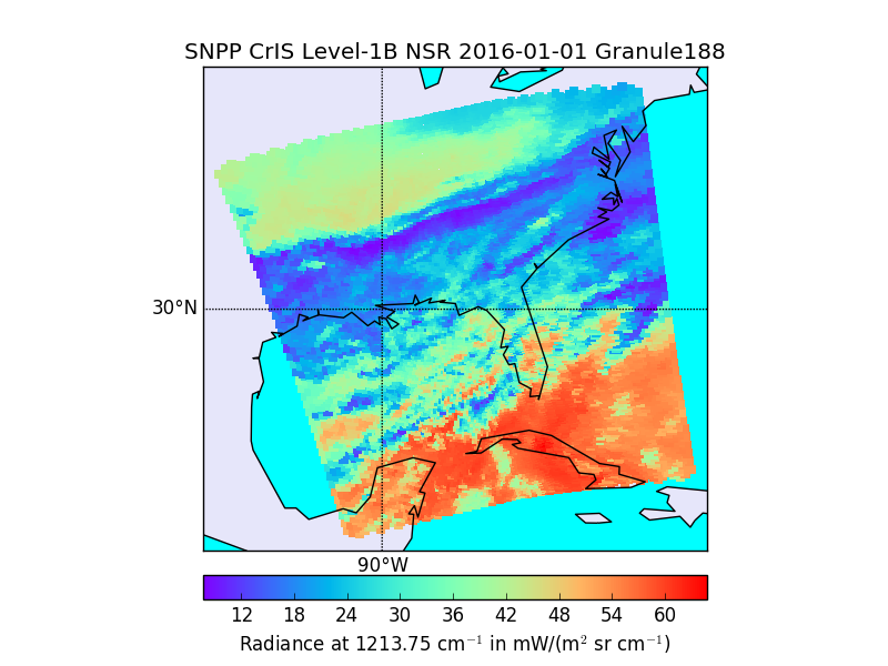
Federal
S-NPP CrIS IMG_COL: Array indices for collocated VIIRS observations V2 (SNDRSNCrISL1BIMGC) at GES DISC
National Aeronautics and Space Administration —
The Cross-track Infrared Sounder (CrIS) Level 1B Normal Spectral Resolution (NSR) data files contain radiance measurements along with ancillary spacecraft,... -
Federal
S-MODE Pre-Pilot Ocean Wave Slope from Visible-Band Polarimetry at the Air-Sea Interaction Tower Version 1
National Aeronautics and Space Administration —
These wave slope data from polarimetry described below are considered preliminary and should not be used for any purpose without consulting Chris Zappa... -
Federal
S-MODE PRISM Level 1 Radiance and Ancillary Products Version 1
National Aeronautics and Space Administration —
This dataset contains PRISM data from the Sub-Mesoscale Ocean Dynamics Experiment (S-MODE) during the IOP1 campaign conducted approximately 300 km offshore of San... -
Federal
Randolph Glacier Inventory - A Dataset of Global Glacier Outlines, Version 2
National Aeronautics and Space Administration —
The Randolph Glacier Inventory (RGI) is a global set of glacier outlines; it is intended as a snapshot of the world’s glaciers. This data set provides a single... -
Federal
Polar Radiant Energy in the Far InfraRed Experiment (PREFIRE) Satellite 2 Raw Payload R01
National Aeronautics and Space Administration —
Polar Radiant Energy in the Far InfraRed Experiment (PREFIRE) Satellite 2 Raw Payload (PREFIRE_SAT2_0-PAYLOAD) contains the uncurated raw measurements from one of two... -
Federal
NPP Multi-Biome: Global Osnabruck Data, 1937-1981, R1
National Aeronautics and Space Administration —
This data set contains three files. The first file provides net primary productivity (NPP) estimates, vegetation characteristics, and summary climate data for 720... -
Federal
Nimbus-7 SMMR Antenna Temperatures, Version 1
National Aeronautics and Space Administration —
The SMMR Antenna Temperatures (Nimbus-7) data set consists of antenna temperatures from passive microwave radiometers aboard NOAA's Nimbus-7 satellite. The instrument... -
State
California Ridgeway's Rail Predicted Habitat - CWHR B144B [ds3236]
State of California —
CWHR Predicted Habitat Models represent areas of predicted suitable habitat for each species within its range. These models are built from the following principal... -
State
Inyo California Towhee Predicted Habitat - CWHR B484A [ds3237]
State of California —
CWHR Predicted Habitat Models represent areas of predicted suitable habitat for each species within its range. These models are built from the following principal... -
State
Riparian Brush Rabbit Predicted Habitat - CWHR M045A [ds3238]
State of California —
CWHR Predicted Habitat Models represent areas of predicted suitable habitat for each species within its range. These models are built from the following principal...

Official websites use .gov
A
.gov website belongs to an official government
organization in the United States.
Secure .gov websites use HTTPS
A
lock (
) or https:// means you’ve safely connected to
the .gov website. Share sensitive information only on official,
secure websites.