
-
Federal
BOREAS 1994 HYD-09 Belfort Rain Gauge Data
National Aeronautics and Space Administration —
This data set contains the measurements from the Belfort rain gauges at the BOREAS NSA andSSA. These measurements were submitted in 15-minute and 1-hour intervals.... -
Federal
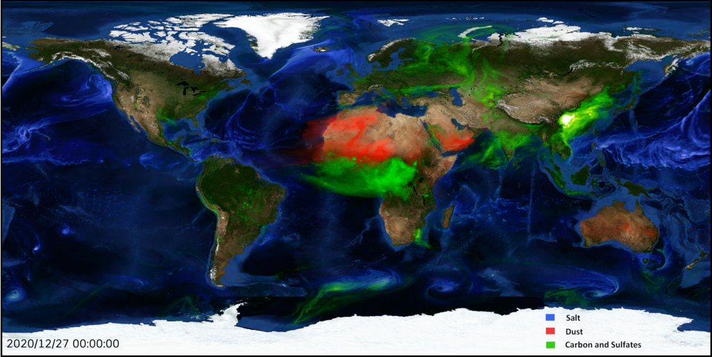
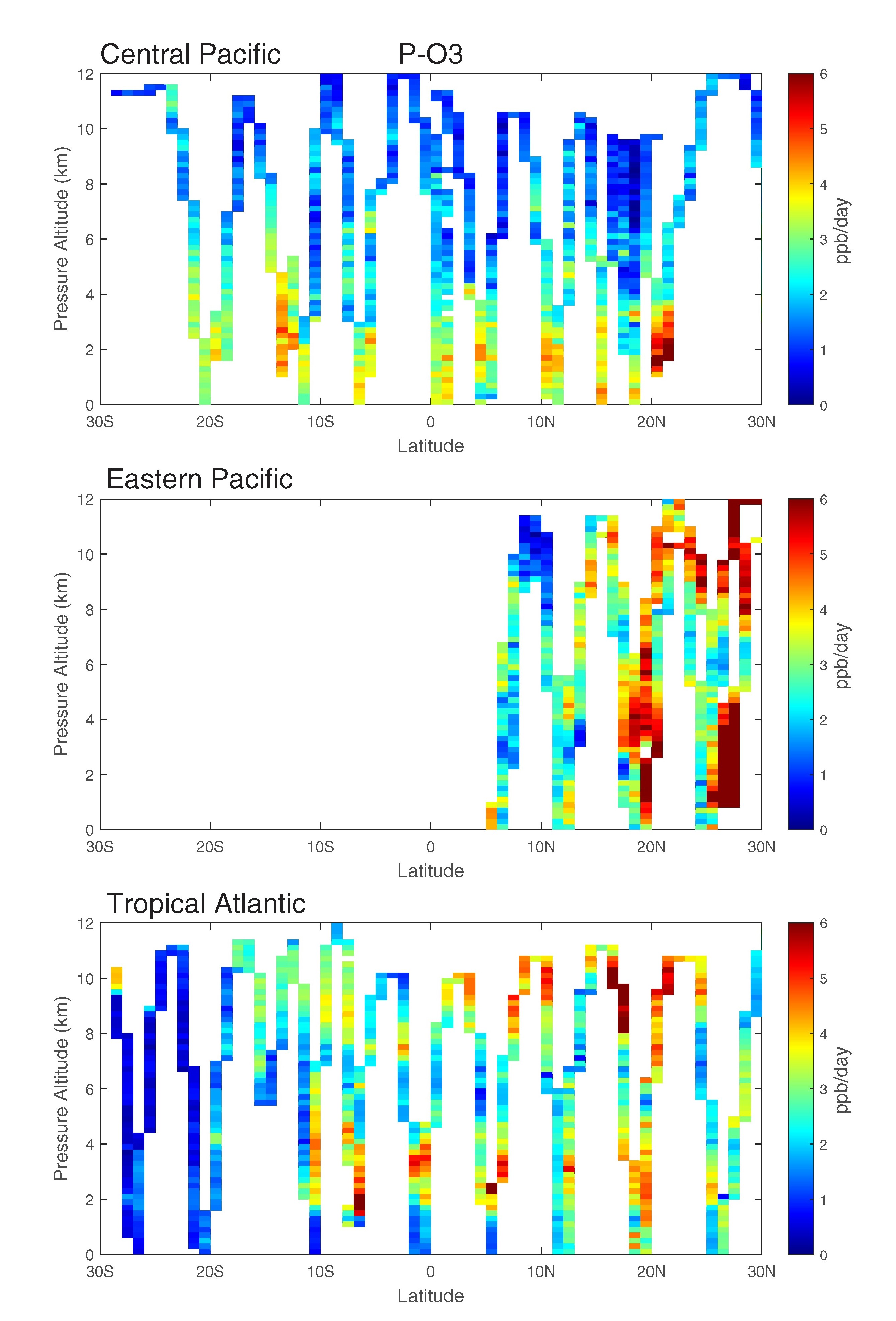
ATom: GEOS-5 Derived Meteorological Conditions and Tagged Tracers Along Flight Tracks
National Aeronautics and Space Administration —
This dataset provides modeled meteorological conditions and tagged-CO tracer concentrations along ATom flight paths derived from the Goddard Earth Observing System... -
Federal
ATom: Cloud and Coarse Aerosol Measurements from CAPS Instrument, 2016-2018
National Aeronautics and Space Administration —
This dataset contains cloud type and coarse aerosol contents measured by the University of Vienna's second-generation Cloud Aerosol and Precipitation Spectrometer... -
Federal
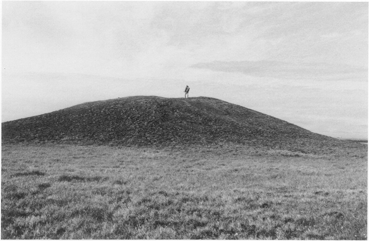
Arctic Vegetation Plots from Pingo Communities, North Slope, Alaska, 1984-1986
National Aeronautics and Space Administration —
This data set provides vegetation species and vegetation plot data collected between 1983 and 1985 from 293 study plots on 41 pingos on the North Slope of Alaska. The... -
Federal
Aquarius Official Release Level 3 Sea Surface Spiciness Standard Mapped Image Ascending Monthly Climatology Data V5.0
National Aeronautics and Space Administration —
Aquarius Level 3 sea surface spiciness standard mapped image data contains gridded 1 degree spatial resolution spice data averaged over daily, 7 day, monthly,and... -
Federal
BOREAS TGB-07 Ambient Air Herbicide and Organochlorine Concentration Data
National Aeronautics and Space Administration —
The BOREAS TGB-07 team measured the concentration and flux of several agricultural pesticides in air, rainwater, and dry deposition samples in order to determine the... -
Federal
BOREAS TE-20 Site Characteristics Data
National Aeronautics and Space Administration —
The BOREAS TE-20 team collected several data sets for use in developing and testing models of forest ecosystem dynamics. This data set contains measurements of site... -
Federal
BOREAS TE-20 NSA Soil Lab Data
National Aeronautics and Space Administration —
This data set contains the major soil properties of soil samples collected at the tower flux sites in the NSA. The soil samples were collected by Hugo Veldhuis and... -
Federal
BOREAS Regional DEM in Raster Format and AEAC Projection
National Aeronautics and Space Administration —
This data set is based on the GTOPO30 DEM produced by the USGS EDC. The BOREAS region (1,000km x 1000km) was extracted from the GTOPO30 data and reprojected by BOREAS... -
Federal
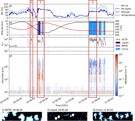
ATom: Development of Cloud Indicator Algorithm Using Airborne Observations from CAPS
National Aeronautics and Space Administration —
This dataset is the basis for the development of the Cloud Indicator, a novel algorithm that automatically detects and classifies measurement periods inside clouds.... -
Federal
Aspen Forest Cover by Stratum/Plot (SNF)
National Aeronautics and Space Administration —
The purpose of the Superior National Forest (SNF) study was to improve our understanding of the relationship between remotely sensed observations and important... -
Federal
Aquarius Official Release Level 3 Rain-flagged Sea Surface Salinity Standard Mapped Image Ascending Monthly Data V5.0
National Aeronautics and Space Administration —
Aquarius Level 3 sea surface salinity (SSS) rain-flagged standard mapped image data contains gridded 1 degree spatial resolution SSS averaged over daily, 7 day,... -
Federal
BOREAS TE-10 Leaf Chemistry Data
National Aeronautics and Space Administration —
The BOREAS TE-10 team collected several data sets in support of its efforts to characterize and interpret information on the reflectance, transmittance, gas exchange,... -
Federal
BOREAS TE-12 SSA Water Potential Data
National Aeronautics and Space Administration —
The BOREAS TE-12 team collected water potential data in 1993 and 1994 from aspen, jack pine and black spruce leaves/needles. Collections were made at the SSA FEN,... -
Federal
BOREAS TE-09 Photosynthetic Capacity and Foliage Nitrogen Data
National Aeronautics and Space Administration —
The BOREAS TE-09 team collected several data sets related to chemical and photosynthetic properties of leaves in boreal forest tree species. This data set describes... -
Federal
BOREAS Follow-On HMet-01 Merged SSM/I and Rain Gauge Precipitation Data
National Aeronautics and Space Administration —
A gridded data set has been assembled over the BOREAS hydro-meteorological study region that combines a precipitation data set based on a rain gauge network with... -
Federal
BigFoot NPP Surfaces for North and South American Sites, 2000-2004
National Aeronautics and Space Administration —
The BigFoot project gathered Net Primary Production (NPP) data for nine EOS Land Validation Sites located from Alaska to Brazil from 2000 to 2004. Each site is... -
Federal
ATom: L2 Particulate Iodine from High-Resolution Aerosol Mass Spectrometer (HR-AMS)
National Aeronautics and Space Administration —
This dataset provides mass concentrations of particulate iodine as measured by the High-Resolution Aerosol Mass Spectrometer (HR-AMS) during the first two deployments... -
Federal
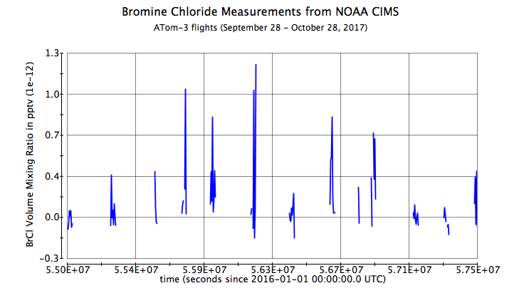
ATom: L2 Measurements from NOAA ToF Chemical Ionization Mass Spectrometer, Version 2
National Aeronautics and Space Administration —
This dataset provides the mixing ratios of reactive nitrogen and halogen species measured by the NOAA Iodide Ion Time-of-Flight Chemical Ionization Mass Spectrometer... -
Federal
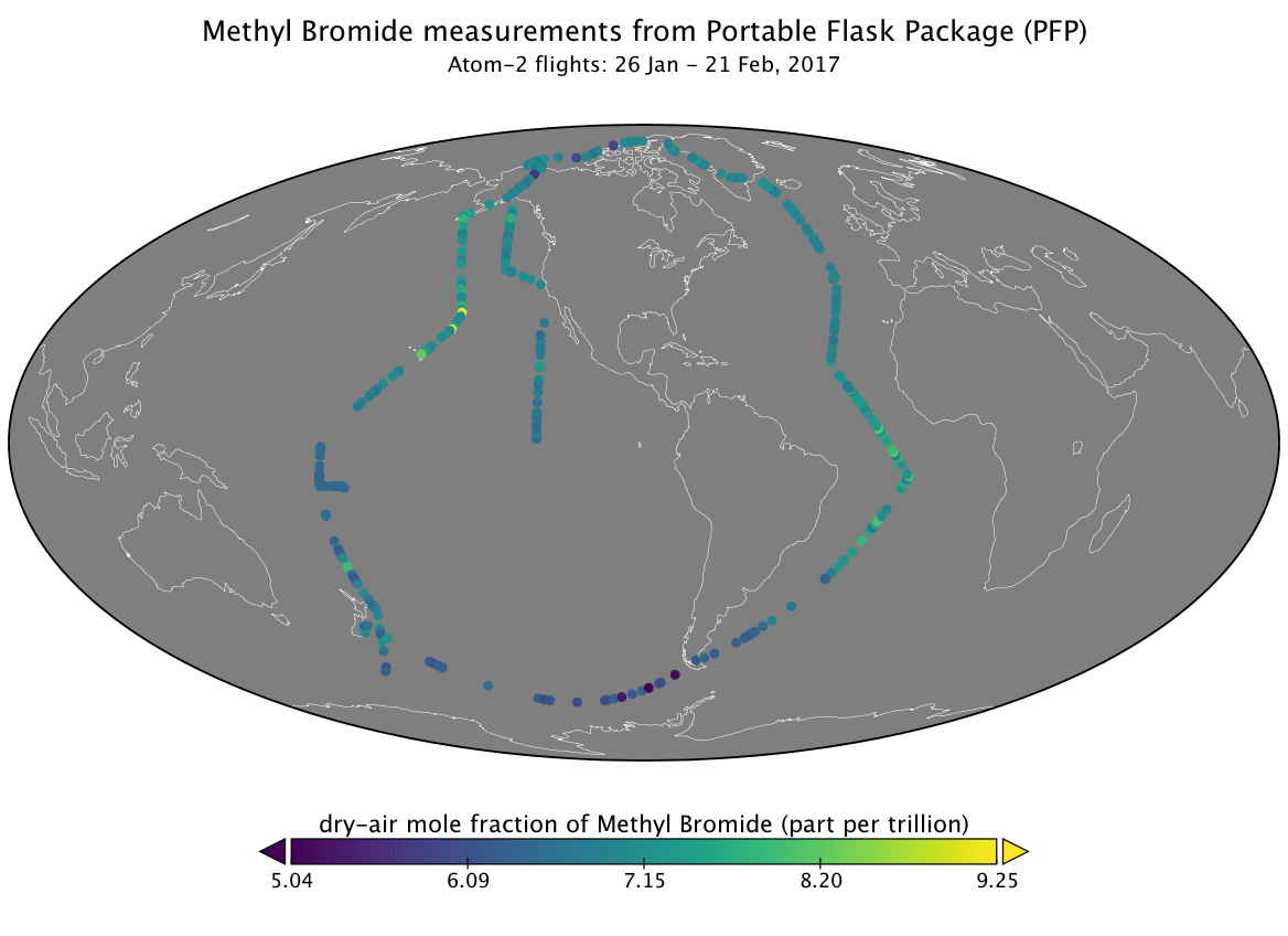
ATom: L2 Measurements from the Programmable Flask Package (PFP) Whole Air Sampler
National Aeronautics and Space Administration —
This dataset provides mole fractions of atmospheric trace gases measured by the Programmable Flask Package (PFP) Whole Air Sampler during airborne campaigns conducted...

Official websites use .gov
A
.gov website belongs to an official government
organization in the United States.
Secure .gov websites use HTTPS
A
lock (
) or https:// means you’ve safely connected to
the .gov website. Share sensitive information only on official,
secure websites.