

260 datasets found for "Tundra"
-
Federal
Low-Altitude Photographic Transects of the Arctic Network of National Park Units and Selawik National Wildlife Refuge, Alaska, July 2013
Department of the Interior —
This data release includes 5 child items with photos and videos taken during low altitude photo survey transects in northwest Alaska, July 2013. Three flight... -
Federal
Vegetation Transects to Measure Effects of Snow Goose Grazing on the Colville River Delta, Alaska
Department of the Interior —
This data release corresponds to visual vegetation measurements in snow goose grazing areas of the Colville River Delta. Visual vegetation measurements data include... -
Federal
Emperor Goose (Anser canagicus) Nest Visit, Fate, and Dispersal Distances from the Yukon-Kuskokwim Delta, Alaska, 2000-2017
Department of the Interior —
These data are in two tables: 1) table relating to emperor goose nest visit, nest fate, and nest dispersal distances on the Yukon-Kuskokwim Delta in Alaska,... -
Federal
Detection of the Aquatic Invasive Species (AIS) Elodea canadensis and E. nuttallii Using Environmental DNA (eDNA), Alaska
Department of the Interior —
This data set is comprised of one table with sampling information and National Center for Biotechnology Information (NCBI) BioProject accession numbers for sequence... -
Federal
Nesting Period Data for Black Brant (Branta bernicla nigricans) in Alaska
Department of the Interior —
This data package contains one table with nest initiation and end dates and clutch sizes from Black Brant (Branta bernicla nigricans) at two breeding colonies in... -
Federal
Flight Path GPS Logs and Browse Maps of Low-Altitude Transects of the Arctic Network of National Park Units and Selawik National Wildlife Refuge, Alaska, July 2013
Department of the Interior —
This dataset contains GPS waypoint logs and browse maps of the aircraft flight paths used during low altitude photo survey transects in northwest Alaska, July 2013.... -
Federal
Oblique Videos Taken During Low-Altitude Transects of the Arctic Network of National Park Units and Selawik National Wildlife Refuge, Alaska, July 2013
Department of the Interior —
This dataset contains aerial oblique video segments from a Panasonic Lumix DMC-FZ200 (24x superzoom, variable focal length) and a Panasonic Lumix DMC-SZ7 (10x... -
Federal
Oblique Photographs Taken During Low-Altitude Transects of the Arctic Network of National Park Units and Selawik National Wildlife Refuge, Alaska, July 2013
Department of the Interior —
This dataset contains aerial oblique digital photos taken of the arctic landscape during low altitude photo survey transects in northwest Alaska, July 2013. Three... -
Federal
Nadir Videos Taken During Low-Altitude Transects of the Arctic Network of National Park Units and Selawik National Wildlife Refuge, Alaska, July 2013
Department of the Interior —
This dataset contains aerial nadir video segments from a GoPro Hero3 Black Edition (focal length 2.77 mm; 60 frames per second) of the arctic landscape during low... -
Federal
Avian Habitat Data, Seward Peninsula, Alaska, 2012
Department of the Interior —
This data package contains two tables with habitat measurements from each sampling point used in avian point-transect surveys on the Seward Peninsula in 2012 and the... -
Federal
Aerial Image of Alaska's Arctic Coastal Plain, 1955
Department of the Interior —
This dataset is comprised of one geo-referenced aerial image from the National Petroleum Reserve - Alaska (NPRA) on Alaska's Arctic Coastal Plain taken on 21 June... -
Federal
Avian Point Count, Habitat, and Covariate Data for Subarctic Bird Abundance, Seward Peninsula, Alaska, 2012-2014
Department of the Interior —
This data package contains three tables: avian counts by species, habitat type, a covariate information used for analysis of bird surveys conducted between 2012 and... -
Federal
Physical, Chemical, and Invertebrate Data from Chipp North Pond Manipulations, North Slope, Alaska, 2013
Department of the Interior —
These data are in five tables related to a series of ponds, visited weekly over the summer of 2013, in the Chipp River Basin on the Arctic Coastal Plain of northern... -
Federal
Aerial Images of Alaska's Arctic Coastal Plain, 1948-1949
Department of the Interior —
This dataset is comprised of 35 geo-referenced aerial images of four study areas (Teshekpuk Lake Special Area, Chipp River, Colville River Delta, and Dalton Highway... -
Federal
Erosion features related to thaw of permafrost in the NPS Arctic Inventory and Monitoring Network, Alaska, 2020 update
Department of the Interior —
Spatial data used for analysis of trends in the occurrence of erosion features caused by thaw in the five National Park Service units of the Arctic Inventory and... -
Federal
1994-1996 Dall Sheep Exclosures Dataset: Yukon-Charley Rivers National Preserve
Department of the Interior —
Little documentation exists for habitat use by Dall’s sheep, or the role sheep play in the disturbance and/or maintenance of sensitive vegetation associations within... -
Federal
Segmentation geospatial data - Land Cover Mapping, North Slope of the Arctic National Wildlife Refuge, Alaska, 2019
Department of the Interior —
"We applied Simple Non-Iterative Clustering (SNIC) (Achanta and Susstrunk 2017) to develop image segments or super-pixels from the WorldView mosaic (Figure 4). Input... -
Federal
Synthesis of Winter In Situ Soil CO2 Flux in pan-Arctic and Boreal Regions, 1989-2017
National Aeronautics and Space Administration —
This dataset provides a synthesis of winter ( September-April) in situ soil CO2 flux measurement data from locations across pan-Arctic and Boreal permafrost regions.... -
Federal
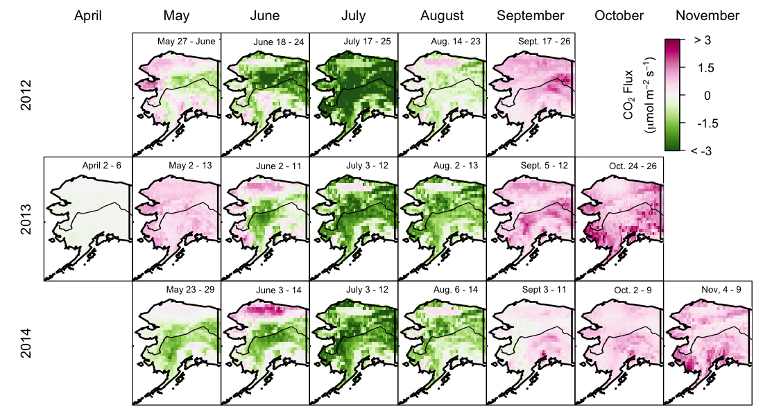
CARVE: Net Ecosystem CO2 Exchange and Regional Carbon Budgets for Alaska, 2012-2014
National Aeronautics and Space Administration —
This data set provides estimates of 3-hourly net ecosystem CO2 exchange (NEE) at 0.5-degree resolution over the state of Alaska for 2012-2014. The NEE estimates are...
260 datasets found for "Tundra"