
-
Federal
LBA Regional Boundary for the Legal Amazon of Brazil, 8-km
National Aeronautics and Space Administration —
The Legal Amazon of Brazil is defined by law to include the states of Acre, Amapá, Amazonas, Pará, Rondônia, Roraima, Mato Grosso, Maranhão, and Tocantins [Fundãcao... -
Federal
Landsat-derived Spring and Autumn Phenology, Eastern US - Canadian Forests, 1984-2013
National Aeronautics and Space Administration —
This dataset provides Landsat phenology algorithm (LPA) derived start and end of growing seasons (SOS and EOS) at 500-m resolution for deciduous and mixed forest... -
Federal
LBA-ECO CD-34 Hyperion 30-m Surface Reflectance, Amazon Basin: 2002-2005
National Aeronautics and Space Administration —
This data set contains 20 multispectral surface reflectance images collected by the EO-1 satellite Hyperion sensor at 30-m resolution and covering the entire Amazon... -
Federal
LBA-ECO CD-07 GOES-8 L3 Gridded Surface Radiation and Rain Rate for Amazonia: 1999
National Aeronautics and Space Administration —
High resolution downwelling solar, PAR, infrared radiation and rain rates retrieved from GOES-8 imager. The data set covers primarily Amazon watershed area. It has... -
Federal
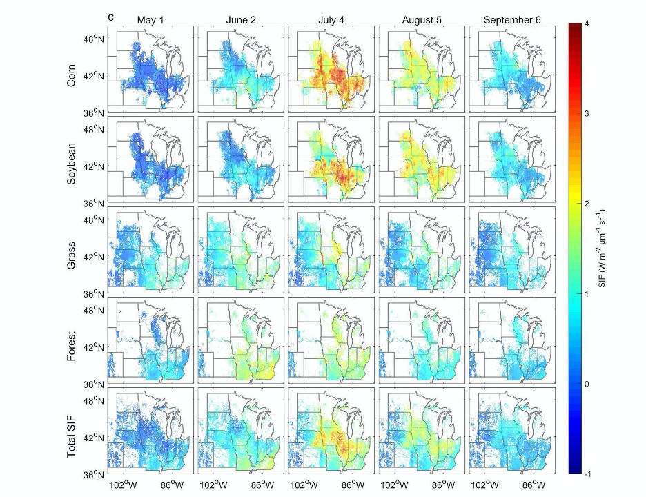
High Resolution Land Cover-Specific Solar-Induced Fluorescence, Midwestern USA, 2018
National Aeronautics and Space Administration —
This dataset provides estimated solar-induced chlorophyll fluorescence (SIF) of specific vegetation types and total SIF under clear-sky and real/cloudy conditions at... -
Federal
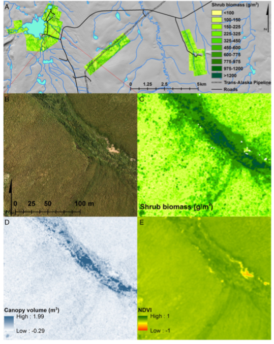
High-Resolution Shrub Biomass and Uncertainty Maps, Toolik Lake Area, Alaska, 2013
National Aeronautics and Space Administration —
This dataset contains estimates for aboveground shrub biomass and uncertainty at high spatial resolution (0.80-m) across three research areas near Toolik Lake,... -
Federal
LBA-ECO ND-02 CO2 Flux from Soils in Forests and Pastures, Acre, Brazil: 1999-2001
National Aeronautics and Space Administration —
This data set reports soil CO2 flux and results of This data set reports soil CO2 flux and results of physical and chemical characterization of soils from pastures,... -
Federal
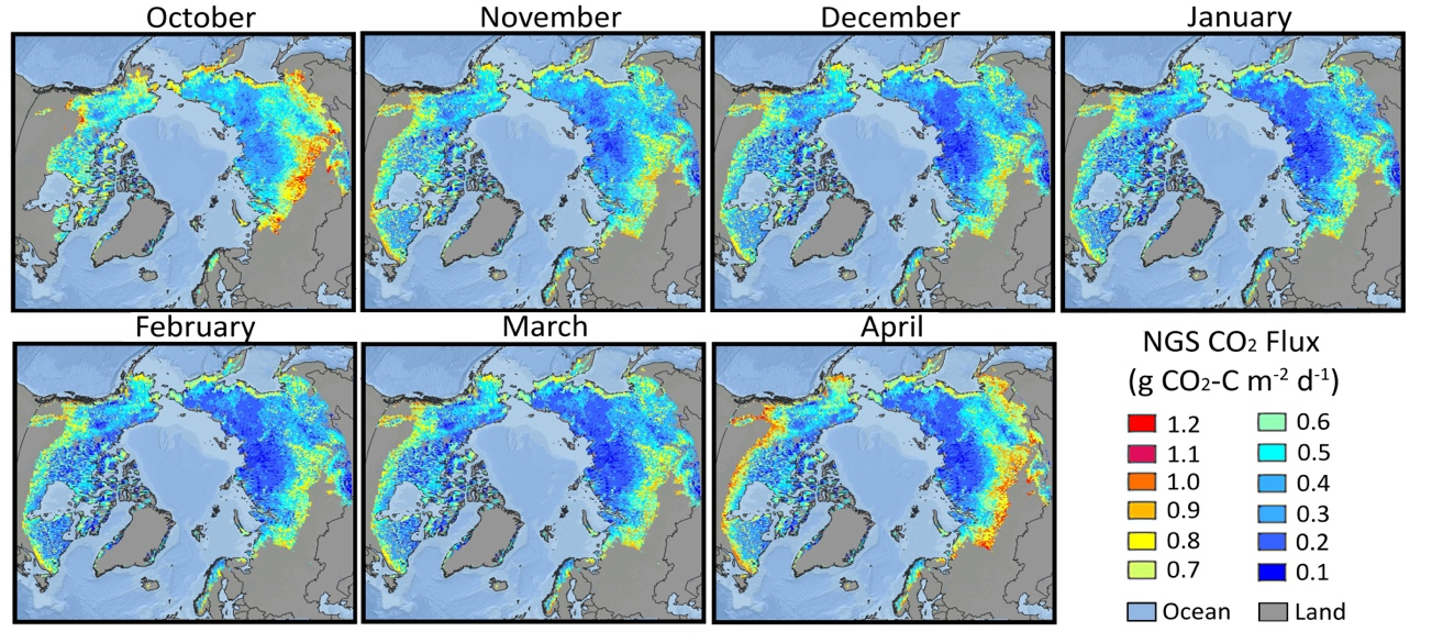
Gridded Winter Soil CO2 Flux Estimates for pan-Arctic and Boreal Regions, 2003-2100
National Aeronautics and Space Administration —
This dataset provides gridded estimates of soil CO2 flux (g C m-2 d-1) for the winter non-growing season (NGS) across pan-Arctic and Boreal permafrost regions (>49... -
Federal
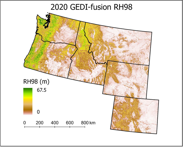
Gridded GEDI-Fusion Forest Structure Metrics across Six Western US States, 2016-2020
National Aeronautics and Space Administration —
This dataset provides eight GEDI forest structure metrics relevant to wildlife habitat modeling and biodiversity assessments at 30-m resolutions across Washington,... -
Federal
ECHIDNA LIDAR Campaigns: Forest Canopy Imagery and Field Data, U.S.A., 2007-2009
National Aeronautics and Space Administration —
This data set contains forest canopy scan data from the Echidna® Validation Instrument (EVI) and field measurements data from three campaigns conducted in the United... -
Federal
Global Soil Data Products CD-ROM Contents (IGBP-DIS)
National Aeronautics and Space Administration —
This dataset contains global data on soil properties, global maps of soil distributions, and the SoilData System developed by the International Geosphere-Biosphere... -
Federal
Forest Biophysical Parameters (SNF)
National Aeronautics and Space Administration —
The purpose of the SNF study was to improve our understanding of the relationship between remotely sensed observations and important biophysical parameters in the... -
Federal
Eddy Corr. Surface Flux: GSFC (FIFE)
National Aeronautics and Space Administration —
The Eddy Correlations Surface Flux Observations (GSFC) Data Set contains surface flux measurements made at selected sites within the FIFE study area. The surface flux... -
Federal
Bowen Ratio Surface Flux: UNL (FIFE)
National Aeronautics and Space Administration —
The Bowen Ratio Surface Flux Observations (UNL) Data Set contains surface flux and micrometeorolgical measurements collected at one location located in a flat area of... -
Federal
LBA-ECO LC-04 Macrohydrological Routing Data for the Amazon and Tocantins River Basin
National Aeronautics and Space Administration —
This data set provides continental-scale hydrological river flow routing parameter data for the Amazon and Tocantins River basins at 5 minute (~9 km) resolution... -
Federal
NWS Daily Climatology Data: 1974 (SNF)
National Aeronautics and Space Administration —
Weather data were collected by the National Weather Service in International Falls, Minnesota. International Falls is about 80 miles from the SNF, but the weather...

Official websites use .gov
A
.gov website belongs to an official government
organization in the United States.
Secure .gov websites use HTTPS
A
lock (
) or https:// means you’ve safely connected to
the .gov website. Share sensitive information only on official,
secure websites.