

259,562 datasets found for "pg电子麻将胡了bug✅澳门葡京赌场官方网站-网址【079.one】㊙️最火爆PG电子超高爆奖率,注册即送38元.NQNJbWrcmAs"
-
Federal
DWH NRDA Wintering Waterbirds Oiled Observations
Department of the Interior —
Data collection for Deepwater Horizon Bird Study #12 occurred in the Spring of 2011. Data were collected primarily by BioDiversity Research Institute (BRI) and R.G.... -
Federal
Vegetation Inventory, Classification, and Mapping - Geodatabase and Map Report [DRAFT]: Minidoka National Wildlife Refuge
Department of the Interior —
Spatial vegetation/habitat database produced for Minidoka National Wildlife Refuge (NWR). Classifications at the level of NVCS Groups and Alliances. This geodatabase... -
Federal
Least-cost corridors (primary model) - A landscape connectivity analysis for the coastal marten (Martes caurina humboldtensis)
Department of the Interior —
This dataset contains the least-cost corridors produced by our habitat connectivity model for the coastal marten, as described below in greater detail: After... -
Federal
VMS Groundfish 2010-2017 (BOEM)
Department of the Interior —
2010-2017 Vessel Monitoring System (VMS) data were used from the NOAA Office of Law Enforcement to create this fishing effort dataset for the U.S. West Coast. The... -
Federal
Willapa NWR: Continuous Air and Stream Temperature Data at Omeara Creek (Aquatic Health and Climate Change) - Raw and Processed Data
Department of the Interior —
Continuous Temperature Data. Raw Hobo data files collected at Willapa NWR (Omeara Creek) and compiled at a regular frequency into a annual (cleaned) dataset (Excel).... -
Federal
Little Pend Oreille NWR: Invasive Plant Inventory - Grid-based: Survey Grid (50 x 50 m) for Conducting Field-based Invasive Plant Surveys
Department of the Interior —
This dataset was created to facilitate field-based invasive plant surveys. Each grid-cell constitutes a possible survey area within which a field surveyor documents... -
Federal
Siletz Estuary Plant Community Mapping - Tabular Data, 2001
Department of the Interior —
Tabular dataset for Siletz Estuary Plant Community Mapping survey, 2001. This study mapped twelve wetland plant communities (or “alliances”) and 59 subcommunities (or... -
Federal
Siletz Estuary Plant Community (Vegetation) Mapping - Geospatial Data, 2001
Department of the Interior —
This study mapped twelve wetland plant communities (or “alliances”) and 59 subcommunities (or “community elements”) in 252 ha (623 A) of tidal and formerly tidal... -
Federal
Land cover and other geospatial layers created for the paper: Evaluating population connectivity and targeting conservation action for an endangered cat. https://doi.org/10.7944/P92D26LI
Department of the Interior —
Lehnen, S. E., Sternberg, M. A., Swarts, H. M., & Sesnie, S. E. 2021. Evaluating population connectivity and targeting conservation action for an endangered cat.... -
Federal
2019 Annual Data Files: Centennial Valley Arctic Grayling Adaptive Management Project, 2011-present
Department of the Interior —
2019's Annual Data files have been uploaded as several digital holdings with data used to support the creation of the Centennial Valley Arctic Grayling Adaptive... -
Federal
LBA-ECO LC-04 THMB Model Simulations for the Amazon and Tocantins Basins: 1939-1998
National Aeronautics and Space Administration —
The model output data provided were generated by the THMB 1.2 (Terrestrial Hydrology Model with Biogeochemistry) model which simulates the flow of water through... -
Federal
LBA-ECO LC-01 Landsat MSS, TM, ETM+ Imagery, Northern Ecuadorian Amazon: 1973-2002
National Aeronautics and Space Administration —
This data set contains a time series of early Landsat-4 MSS satellite imagery as well as Landsat-5 TM and Landsat-7 ETM+ satellite imagery of the northern Ecuadorian... -
Federal
LBA-ECO CD-10 H2O Profiles at km 67 Tower Site, Tapajos National Forest
National Aeronautics and Space Administration —
This data set reports vertical profiles of H2O vapor concentrations measured at the Para Western (Santarem) - km 67, Primary Forest Tower Site (Figure 1). This site... -
Federal
LBA-ECO CD-10 Tree DBH Measurements at the km 67 Tower Site, Tapajos National Forest
National Aeronautics and Space Administration —
This data sets reports diameter at breast height (DBH) measurements in the old-growth upland forest at the Para Western (Santarem) - km 67, Primary Forest Tower Site.... -
Federal
LBA-ECO CD-06 CO2 Exchange in River Systems Across the Amazon Basin: 2004-2007
National Aeronautics and Space Administration —
This data set provides measurements of carbon dioxide flux rates (FCO2), gas transfer velocity (k), and partial pressures (pCO2) at 75 sites on rivers and streams of... -
Federal
ISLSCP II Global Gridded Soil Characteristics
National Aeronautics and Space Administration —
This data set provides gridded data for selected soil parameters derived from data and methods developed by the Global Soil Data Task, an international collaborative... -
Federal
ISLSCP II Globalview: Atmospheric CO2 Concentrations
National Aeronautics and Space Administration —
The GlobalView Carbon Dioxide (CO2) data product contains synchronized and smoothed time series of atmospheric CO2 concentrations at selected sites that were created... -
Federal
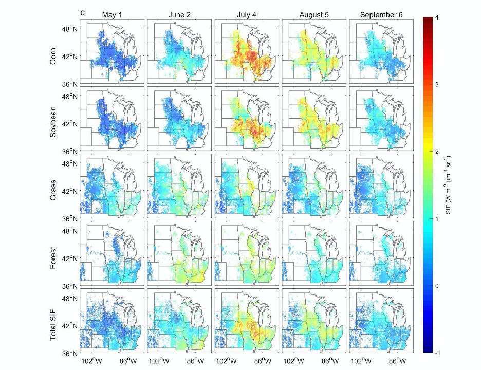
High Resolution Land Cover-Specific Solar-Induced Fluorescence, Midwestern USA, 2018
National Aeronautics and Space Administration —
This dataset provides estimated solar-induced chlorophyll fluorescence (SIF) of specific vegetation types and total SIF under clear-sky and real/cloudy conditions at... -
Federal
GRACE NON-TIDAL OCEAN GEOPOTENTIAL COEFFICIENTS GFZ RELEASE 6.0 GAB
National Aeronautics and Space Administration —
FOR EXPERT USE ONLY. This dataset contains estimates of geopotential field derived from the Gravity Recovery and Climate Experiment (GRACE) mission measurements and a...
259,562 datasets found for "pg电子麻将胡了bug✅澳门葡京赌场官方网站-网址【079.one】㊙️最火爆PG电子超高爆奖率,注册即送38元.NQNJbWrcmAs"