
-
Federal
Global Maps of Atmospheric Nitrogen Deposition, 1860, 1993, and 2050
National Aeronautics and Space Administration —
This data set provides global gridded estimates of atmospheric deposition of total inorganic nitrogen (N), NHx (NH3 and NH4+), and NOy (all oxidized forms of nitrogen... -
Federal
GPM Ground Validation UNCA Upper Air Radiosonde IPHEx V1
National Aeronautics and Space Administration —
The GPM Ground Validation UNCA Upper Air Radiosonde IPHEx dataset was collected from April 29, 2014 through June 12, 2014 during the GPM Ground Validation Integrated... -
Federal
GPM Ground Validation Airborne Precipitation Radar 3rd Generation (APR-3) OLYMPEX V2
National Aeronautics and Space Administration —
The GPM Ground Validation Airborne Precipitation Radar 3rd Generation (APR-3) OLYMPEX V2 dataset was collected from November 12, 2015 to December 19, 2015 during the... -
Federal
GPM ATMS on NOAA-20 (GPROF) Climate-based Radiometer Precipitation Profiling L3 1 day 0.25 degree x 0.25 degree V07 (GPM_3GPROFNOAA20ATMS_DAY_CLIM) at GES DISC
National Aeronautics and Space Administration —
Version 07 is the current version of the data set. Older versions are no longer available and have been superseded by Version 07. The "CLIM" products differ from... -
Federal
GPM GROUND VALIDATION MICRO RAIN RADAR (MRR) NASA ACHIEVE IPHEX V1
National Aeronautics and Space Administration —
The GPM Ground Validation Micro Rain Radar (MRR) NASA ACHIEVE IPHEx dataset was gathered during the Global Precipitation Measurement (GPM) Ground Validation... -
Federal
ECHIDNA LIDAR Campaigns: Forest Canopy Imagery and Field Data, U.S.A., 2007-2009
National Aeronautics and Space Administration —
This data set contains forest canopy scan data from the Echidna® Validation Instrument (EVI) and field measurements data from three campaigns conducted in the United... -
Federal
Forest Structure and Biomass Data, La Selva, Costa Rica: 2006
National Aeronautics and Space Administration —
This data set provides field measurements of diameter, tree height, and crown dimensions for 1,513 trees in 30 plots at the La Selva Biological Station in Costa Rica.... -
Federal
Global River Discharge, 1807-1991, V[ersion]. 1.1 (RivDIS)
National Aeronautics and Space Administration —
The Global Monthly River Discharge Data Set (RivDIS) contains monthly averaged discharge measurements for 1,018 stations located throughout the world from 1807-1991.... -
Federal
Global Salt Marsh Change, 2000-2019
National Aeronautics and Space Administration —
This dataset provides global salt marsh change, including loss and gain for five-year periods from 2000-2019. Loss and gain at a 30 m spatial resolution were... -
Federal
GHRSST Level 2P Global Sea Surface Temperature v2.0 from the AVHRR on the MetOp-B satellite produced by NAVO
National Aeronautics and Space Administration —
A global Group for High Resolution Sea Surface Temperature (GHRSST) Level 2P data set containing multi-channel Sea Surface Temperature (SST) retrievals derived in... -
Federal
GHRSST Level 2P Global Sea Surface Temperature v2.0 from the AVHRR on the MetOp-C satellite produced by NAVO
National Aeronautics and Space Administration —
A global Group for High Resolution Sea Surface Temperature (GHRSST) Level 2P data set containing multi-channel Sea Surface Temperature (SST) retrievals derived in... -
Federal
First ISCCP Regional Experiment (FIRE) Cirrus Phase II NCAR Kingair Aircraft 2D Probe Data
National Aeronautics and Space Administration —
The First ISCCP Regional Experiments have been designed to improve data products and cloud/radiation parameterizations used in general circulation models (GCMs).... -
Federal
FLEXPART organic carbon aerosol L4 global daily 1 x 1 degrees V1 (OCFLEXPART)
National Aeronautics and Space Administration —
This is a global simulation of organic carbon (OC) aerosol concentrations and daily deposition (wet+dry) from the FLEX-ible PARTicle (FLEXPART) Lagrangian particle... -
Federal
First ISCCP Regional Experiment (FIRE) Atlantic Stratocumulus Transition Experiment (ASTEX) Rawinsonde Level 2 Data
National Aeronautics and Space Administration —
The First ISCCP Regional Experiments (FIRE) have been designed to improve data products and cloud/radiation parameterizations used in general circulation models... -
Federal
First ISCCP Regional Experiment (FIRE) Arctic Cloud Experiment (ACE) Solar Spectral Flux Radiometer (SSFR)
National Aeronautics and Space Administration —
The First ISCCP Regional Experiments have been designed to improve data products and cloud/radiation parameterizations used in general circulation models (GCMs).... -
Federal
Global Space-based Stratospheric Aerosol Climatology Version 2.21
National Aeronautics and Space Administration —
The Global Space-based Stratospheric Aerosol Climatology, or GloSSAC, is a 44-year climatology of stratospheric aerosol properties focused on extinction coefficient... -
Federal
GHRSST L3C hourly America Region sub-skin Sea Surface Temperature v1.0 from ABI on GOES16 produced by OSISAF
National Aeronautics and Space Administration —
The data is regional and part of the Group for High Resolution Sea Surface Temperature (GHRSST) Level 3 Collated (L3C) dataset covering the America Region based on... -
Federal
First ISCCP Regional Experiment (FIRE) Cirrus Phase II Raman Lidar Data
National Aeronautics and Space Administration —
The First ISCCP Regional Experiments have been designed to improve data products and cloud/radiation parameterizations used in general circulation models (GCMs).... -
Federal
Eddy Corr. Surface Flux: GSFC (FIFE)
National Aeronautics and Space Administration —
The Eddy Correlations Surface Flux Observations (GSFC) Data Set contains surface flux measurements made at selected sites within the FIFE study area. The surface flux... -
Federal
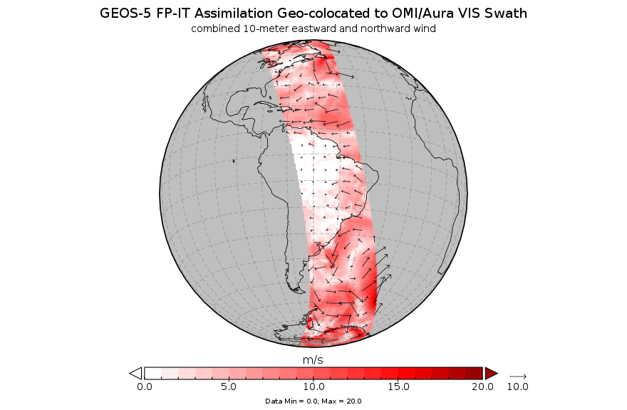
GEOS-5 FP-IT Assimilation Geo-colocated to OMI/Aura VIS 1-Orbit L2 Support Swath 13x24km V3 (OMVFPITMET) at GES DISC
National Aeronautics and Space Administration —
The GEOS-5 FP-IT Assimilation Geo-colocated to OMI/Aura VIS 1-Orbit L2 Support Swath 13x24km (OMVFPITMET) provides selected parameters from GEOS-5 Forward Processing...

Official websites use .gov
A
.gov website belongs to an official government
organization in the United States.
Secure .gov websites use HTTPS
A
lock (
) or https:// means you’ve safely connected to
the .gov website. Share sensitive information only on official,
secure websites.