
-
Federal
GPM TMI on TRMM unpacked data L1A 1.5 hours 13 km V07 (GPM_1ATMI) at GES DISC
National Aeronautics and Space Administration —
This is the new (GPM-formated) TRMM product. It replaces the old TRMM_1A11 Version 07 is the current version of the data set. Previous versions have been superseded... -
Federal
GPM Ground Validation Kumpula Mast Meteorological Data LPVEx V1
National Aeronautics and Space Administration —
The GPM Ground Validation Kumpula Mast Meteorological Data LPVEx dataset is comprised of temperature, radiation, and wind measurements collected by the Station for... -
Federal
GPM Ground Validation Duke Soil Moisture IPHEx
National Aeronautics and Space Administration —
The GPM Ground Validation Duke Soil Moisture dataset consists of a collection of various data obtained during the Integrated Precipitation and Hydrology Experiment... -
Federal
GHRSST Level 3U Global Near-Real-Time Subskin Sea Surface Temperature version 8a from the Advanced Microwave Scanning Radiometer 2 on the GCOM-W satellite
National Aeronautics and Space Administration —
GDS2 Version -The Advanced Microwave Scanning Radiometer 2 (AMSR2) was launched on 18 May 2012, onboard the Golbal Change Observation Mission - Water (GCOM-W)... -
Federal
GHRSST Level 2P 1 m Depth Global Sea Surface Temperature from VIIRS on Suomi NPP (GDS2) V1
National Aeronautics and Space Administration —
A global Group for High Resolution Sea Surface Temperature (GHRSST) Level 2P dataset based on retrievals from the Visible Infrared Imaging Radiometer Suite (VIIRS).... -
Federal
CatWISE Preliminary Reject Table
National Aeronautics and Space Administration —
The CatWISE Preliminary catalog contains positions and brightnesses for 900,849,014 sources selected from combined WISE and NEOWISE all-sky survey data collected from... -
Federal
GRACE-FO Level-2 Monthly Geopotential Spherical Harmonics CSR Release 06.3 (RL06.3)
National Aeronautics and Space Administration —
FOR EXPERT USE ONLY. This dataset contains estimates of the total month-by-month geopotential of the Earth, derived from the Gravity Recovery and Climate Experiment... -
Federal
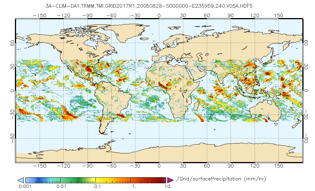
GPM TMI on TRMM (GPROF) Climate-based Radiometer Precipitation Profiling L3 1 day 0.25 degree x 0.25 degree V07 (GPM_3GPROFTRMMTMI_DAY_CLIM) at GES DISC
National Aeronautics and Space Administration —
This a new (GPM-formated) TRMM product. There is no equivalent in the old TRMM suite of products. Version 07 is the current version of the data set. Older versions... -
Federal
GPM VIRS on TRMM unpacked data L1A 1.5 hours 2 km V07 (GPM_1AVIRS) at GES DISC
National Aeronautics and Space Administration —
This is the new (GPM-formated) TRMM product. It replaces the old TRMM_1A01 Version 07 is the current version of the data set. Previous versions have been superseded... -
Federal
GPM ATMS on SUOMI-NPP (GPROF) Radiometer Precipitation Profiling L2 1.5 hours 16 km V07 (GPM_2AGPROFNPPATMS) at GES DISC
National Aeronautics and Space Administration —
Version 07 is the current version of the data set. Older versions will no longer be available and have been superseded by Version 07. The 2AGPROF (Goddard Profiling)... -
Federal
GRACE NON-TIDAL OCEAN GEOPOTENTIAL COEFFICIENTS GFZ RELEASE 6.0 GAB
National Aeronautics and Space Administration —
FOR EXPERT USE ONLY. This dataset contains estimates of geopotential field derived from the Gravity Recovery and Climate Experiment (GRACE) mission measurements and a... -
Federal
GPM PR on TRMM Reflectivity, Precipitation Characteristics and Rate, at Surface and Profile L2 1.5 hours V07 (GPM_2APR) at GES DISC
National Aeronautics and Space Administration —
This is the new, GPM-like, format for TRMM Precipitation Radar L2 data that now incorporates what was known as 2A21, 2A23 and 2A25 datasets.The primary purpose of... -
Federal
GPM GMI Antenna Temperatures L1BASE 1.5 hours 13 km V07 (GPM_BASEGPMGMI) at GES DISC
National Aeronautics and Space Administration —
Version 07 is the current version of the data set. Older versions are no longer available and have been superseded by the current version.GMI is a multi-channel,... -
Federal
Global Maps of Atmospheric Nitrogen Deposition, 1860, 1993, and 2050
National Aeronautics and Space Administration —
This data set provides global gridded estimates of atmospheric deposition of total inorganic nitrogen (N), NHx (NH3 and NH4+), and NOy (all oxidized forms of nitrogen... -
Federal
GPM Ground Validation UNCA Upper Air Radiosonde IPHEx V1
National Aeronautics and Space Administration —
The GPM Ground Validation UNCA Upper Air Radiosonde IPHEx dataset was collected from April 29, 2014 through June 12, 2014 during the GPM Ground Validation Integrated... -
Federal
GPM Ground Validation Airborne Precipitation Radar 3rd Generation (APR-3) OLYMPEX V2
National Aeronautics and Space Administration —
The GPM Ground Validation Airborne Precipitation Radar 3rd Generation (APR-3) OLYMPEX V2 dataset was collected from November 12, 2015 to December 19, 2015 during the... -
Federal
GPM ATMS on NOAA-20 (GPROF) Climate-based Radiometer Precipitation Profiling L3 1 day 0.25 degree x 0.25 degree V07 (GPM_3GPROFNOAA20ATMS_DAY_CLIM) at GES DISC
National Aeronautics and Space Administration —
Version 07 is the current version of the data set. Older versions are no longer available and have been superseded by Version 07. The "CLIM" products differ from... -
Federal
GPM GROUND VALIDATION MICRO RAIN RADAR (MRR) NASA ACHIEVE IPHEX V1
National Aeronautics and Space Administration —
The GPM Ground Validation Micro Rain Radar (MRR) NASA ACHIEVE IPHEx dataset was gathered during the Global Precipitation Measurement (GPM) Ground Validation... -
Federal
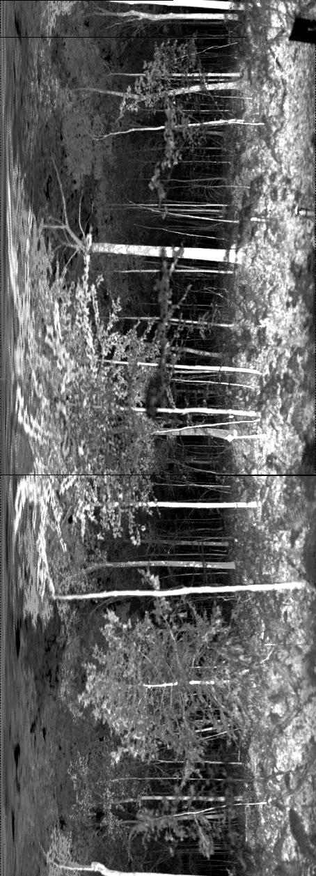
ECHIDNA LIDAR Campaigns: Forest Canopy Imagery and Field Data, U.S.A., 2007-2009
National Aeronautics and Space Administration —
This data set contains forest canopy scan data from the Echidna® Validation Instrument (EVI) and field measurements data from three campaigns conducted in the United... -
Federal
Forest Structure and Biomass Data, La Selva, Costa Rica: 2006
National Aeronautics and Space Administration —
This data set provides field measurements of diameter, tree height, and crown dimensions for 1,513 trees in 30 plots at the La Selva Biological Station in Costa Rica....

Official websites use .gov
A
.gov website belongs to an official government
organization in the United States.
Secure .gov websites use HTTPS
A
lock (
) or https:// means you’ve safely connected to
the .gov website. Share sensitive information only on official,
secure websites.