

2,444 datasets found for "pg麻将胡了500一把视频✅澳门葡京赌场官方网站-网址【079.one】㊙️最火爆PG电子超高爆奖率,注册即送38元.rzvszmNwrG"
-
Federal
Data File for iAs Dose-response Manuscripts - Data files used in preparing four manuscripts describing dose-response methods that have been developed for the purposes of the EPA inorganic arsenic IRIS health assessment.
U.S. Environmental Protection Agency —
These datasets contain information used in support of tables, figures and conclusions made in four manuscripts related to EPA methods developed for the dose-response... -
Federal
Examining NTA Performance and Potential Using Fortified and Reference House Dust as Part of EPA's Non-Targeted Analysis Collaborative Trial (ENTACT)
U.S. Environmental Protection Agency —
The current study focuses on the analysis of SRM 2585 extracts that were distributed as part of ENTACT. It further introduces a separate recovery experiment, using... -
Federal
Utah FORGE 5-2557: Wellbore Breakout Tests Data
Department of Energy —
Included are datasets from wellbore breakout experiments conducted under triaxial conditions with varying fluid and temperature environments. This dataset serves as... -
State
Quaternary Geology Geologic Basin Boundary
State of Connecticut —
Connecticut Quaternary Geology Geologic Basin Divides includes the drainage basins divides appearing on Sheet 1 of the The Quaternary Geologic Map of Connecticut and... -
Federal
Effects of the diphenyl herbicide, oxyfluorfen, on thyroid hormones in the juvenile rat following 4- and 8-day exposure..
U.S. Environmental Protection Agency —
Data on hormone and chemical analysis is included for the effects of oxyfluorfen on thyroid hormones in the 4- and 8-day exposed juvenile rats. This dataset is... -
Federal
Data for Moose Population Survey on Western Yukon Flats NWR - Spring, March 2004
Department of the Interior —
The population estimate for the western Yukon Flats in Game Management Unit (GMU) 25D (2,269 square miles) was 632 moose (Alces alces) with a certainty of +1- 20%... -
Federal
Ozone- Induced Acute Phase Response in Lung Versus Liver: The Role of Adrenal-Derived Stress Hormones
U.S. Environmental Protection Agency —
The data set pertains to the published research results in a given paper. Individual observations are shown for each pertaining figure or table in the paper. Each... -
Federal
State Summary Arkansas FY2017
Department of Veterans Affairs —
The FY2017 State Summaries provide an overview of benefits, services, demographics and population of Veterans analyzed by state. -
Federal
NOAA/WDS Paleoclimatology - GISP2 Ice Core 1000 Year Ar-N2 Isotope Temperature Reconstruction
National Oceanic and Atmospheric Administration, Department of Commerce —
This archived Paleoclimatology Study is available from the NOAA National Centers for Environmental Information (NCEI), under the World Data Service (WDS) for... -
Federal
USDA Rural Development Community Facilities Loan, Grant, and Guaranteed Loan Data
Department of Agriculture —
Locations and characteristics of projects that have received USDA Rural Development Community Facilities Loans, Grants, and Guaranteed Loans. Includes latitude and... -
Federal
ScID_A-d51q_Biochemical effects of nano copper in HepG2 cells_kitchin
U.S. Environmental Protection Agency —
transformed raw data of biochemical paramiters. This dataset is associated with the following publication: Kitchin, K., J. Richards, B. Robinette, K. Wallace, N.H.... -
State
Water Rights Demand Analysis Methodology Datasets
State of California —
The following datasets are used for the Water Rights Demand Analysis project and are formatted to be used in the calculations. The State Water Resources Control Board... -
Federal
LRIR/Nimbus-6 Level 2 Inverted Profiles of Temperature and Ozone V001 (LRIRN6L2IPAT) at GES DISC
National Aeronautics and Space Administration —
LRIRN6L2IPAT is the Nimbus-6 Limb Radiance Inversion Radiometer (LRIR) Level 2 Inverted Profiles of Temperature and Ozone data product. The product contains daily... -
Federal
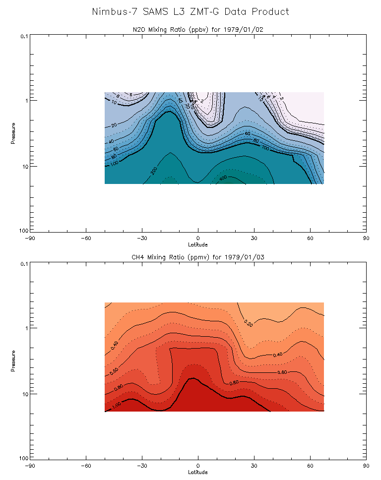
SAMS/Nimbus-7 Level 3 Zonal Means Composition Data V001 (SAMSN7L3ZMTG) at GES DISC
National Aeronautics and Space Administration —
SAMSN7L3ZMTG is the Nimbus-7 Stratospheric and Mesospheric Sounder (SAMS) Level 3 Zonal Means Composition Data Product. The Earth's surface is divided into 2.5-deg... -
Federal
TIROS-4 Medium-Resolution Scanning Radiometer Level 1 Final Meteorological Radiation Data V001 (TIROS4L1FMRT) at GES DISC
National Aeronautics and Space Administration —
TIROS-4 Medium-Resolution Scanning Radiometer Level 1 Final Meteorological Radiation Data (FMRT) product contains radiances expressed in five infrared/visible... -
Federal
TIROS-3 Medium-Resolution Scanning Radiometer Level 1 Final Meteorological Radiation Data V001 (TIROS3L1FMRT) at GES DISC
National Aeronautics and Space Administration —
TIROS-3 Medium-Resolution Scanning Radiometer Level 1 Final Meteorological Radiation Data (FMRT) product contains radiances expressed in five infrared/visible... -
Federal
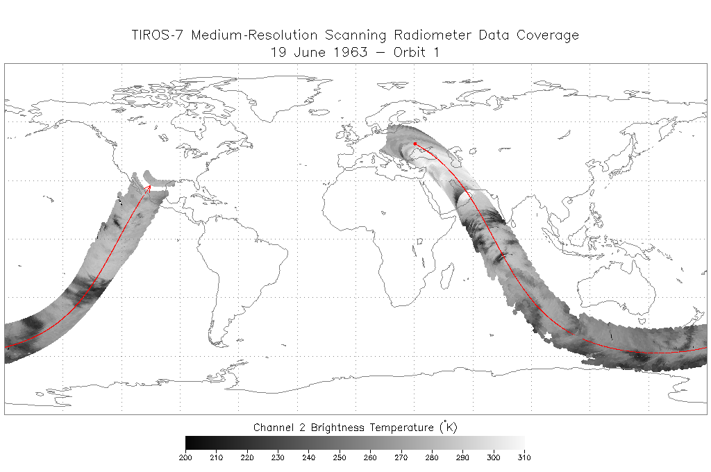
TIROS-7 Medium-Resolution Scanning Radiometer Level 1 Final Meteorological Radiation Data V001 (TIROS7L1FMRT) at GES DISC
National Aeronautics and Space Administration —
TIROS-7 Medium-Resolution Scanning Radiometer Level 1 Final Meteorological Radiation Data (FMRT) product contains radiances expressed in five infrared/visible... -
State
Los Angeles River Restoration and Access (LLARRA) Water Quality Analysis - Lower Los Angeles River - 2024-2025
State of California —
WCB Grant 2023114: Lower Los Angeles River Restoration and Access: Data includes one (1) year of water quality analysis to inform the design and serve as a baseline... -
Federal
BLM Natl WesternUS FIAT Project Planning Areas 2015 Polygon
Department of the Interior —
This data represents a management strategy of the Fire and Invasives Assessment Tool (FIAT). Project Planning Area (PPA) polygons are part of the FIAT Step 2 process.... -
Federal
DWH NRDA Low Level Aerial Surveys
Department of the Interior —
Aerial surveys associated with Deepwater Horizon Bird Study #2 occurred during the summer of 2010 and the winter of 2011. Data collection efforts were led by R.G....
2,444 datasets found for "pg麻将胡了500一把视频✅澳门葡京赌场官方网站-网址【079.one】㊙️最火爆PG电子超高爆奖率,注册即送38元.rzvszmNwrG"