
-
Federal
Global Leaf Area Index from Field Measurements, 1932-2000
National Aeronautics and Space Administration —
Approximately 1000 published estimates of leaf area index (LAI) from nearly 400 unique field sites, covering the period 1932-2000, have been compiled into a single... -
Federal
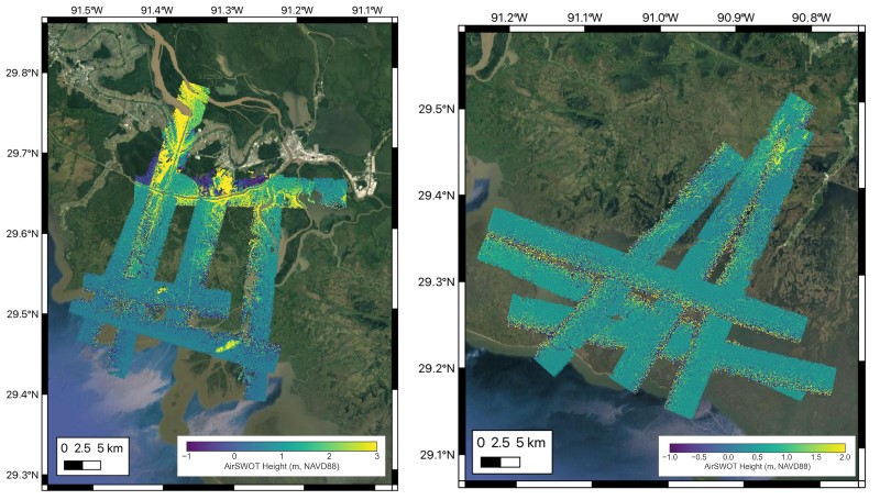
Delta-X: Belowground Biomass and Necromass across Wetlands, MRD, LA, USA, 2021, V2
National Aeronautics and Space Administration —
This dataset contains total belowground biomass (BGB) and necromass (BGN), and total carbon, total nitrogen, and total phosphorus content of samples collected from... -
Federal
CAMP2Ex Learjet In-Situ Cloud Data
National Aeronautics and Space Administration —
CAMP2Ex_Cloud_AircraftInSitu_Learjet_Data are in-situ cloud measurements conducted onboard the SPEC Learjet aircraft during the Clouds, Aerosol and Monsoon Processes-... -
Federal
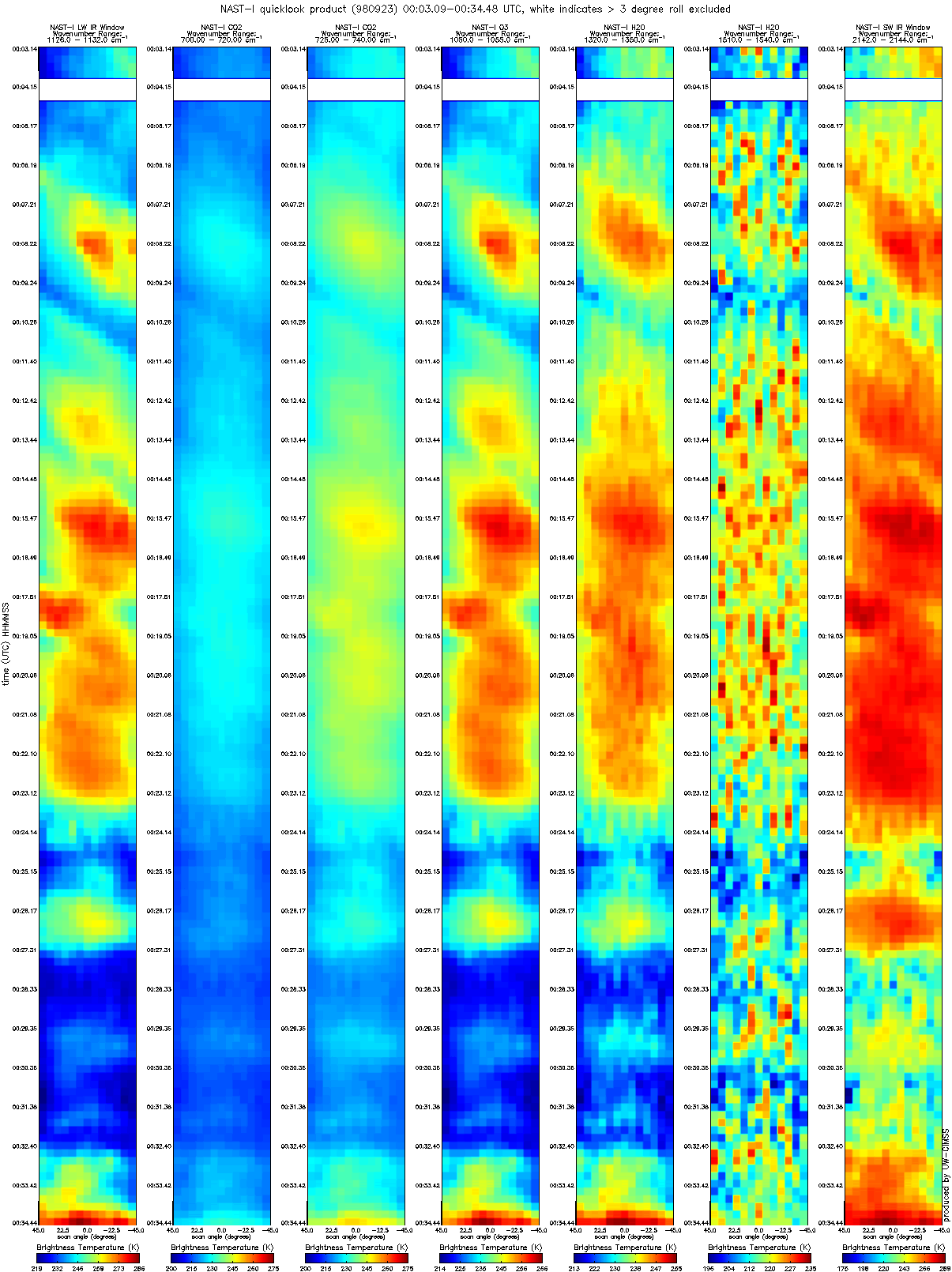
CAMEX-3 NAST-I RADIANCE PRODUCTS V1
National Aeronautics and Space Administration —
The National Polar-orbiting Operational Environmental Satellite System (NPOESS) Atmospheric Sounding Testbed (NAST) is a suite of airborne infrared and microwave... -
Federal
BOREAS TF-08 NSA-OJP Tower Flux, Meteorological, and Soil Temperature Data
National Aeronautics and Space Administration —
The BOREAS TF-08 team collected energy, CO2, and water vapor flux data at the BOREAS NSA-OJP site during the growing season of 1994 and most of the year for 1996. -
Federal
BOREAS TGB-12 Radon-222 Flux Data: NSA
National Aeronautics and Space Administration —
The BOREAS TGB-12 team made measurements of soil carbon inventories, carbon concentration in soil gases, and rates of soil respiration at several sites to estimate... -
Federal
BOREAS TE-05 Tree Ring and Carbon Isotope Ratio Data
National Aeronautics and Space Administration —
These data include tree ring widths and cellulose carbon isotope data from coniferous trees collected at the BOREAS NSA and SSA by the BOREAS TE-05 team. Ring width... -
Federal
BOREAS TE-12 SSA Shoot Geometry Data
National Aeronautics and Space Administration —
The BOREAS TE-12 team collected shoot geometry data in 1993 and 1994 from Aspen, Jack Pine, and Black Spruce trees. Collections were made at the Southern Study Area... -
Federal
ARISE 2014 C-130 Remotely Sensed Aerosol and Trace Gas Data
National Aeronautics and Space Administration —
ARISE_Cloud_AircraftInSitu_C130_Data_1 is the Arctic Radiation - IceBridge Sea & Ice Experiment (ARISE) 2014 in-situ cloud data product. This product is a result... -
Federal
Aquarius Official Release Level 3 Sea Surface Salinity Standard Mapped Image Descending 28-Day Running Mean Data V5.0
National Aeronautics and Space Administration —
Aquarius Level 3 sea surface salinity (SSS) standard mapped image data contains gridded 1 degree spatial resolution SSS averaged over daily, 7 day, monthly, and... -
Federal
MLS/Aura Level 3 Daily Binned Relative Humidity With Respect To Ice (RHI) on Zonal and Similar Grids V005 (ML3DZRHI) at GES DISC
National Aeronautics and Space Administration —
ML3DZRHI is the EOS Aura Microwave Limb Sounder (MLS) daily binned on zonal and assorted vertical grids product for relative humidity with respect to ice (RHI)... -
Federal
MISR Level 2 TOA/Cloud Albedo parameters V002
National Aeronautics and Space Administration —
Multi-angle Imaging SpectroRadiometer (MISR) is designed to view Earth with cameras pointed in 9 different directions. As the instrument flies overhead, each piece of... -
Federal
Measurements from the Baltic Sea in 1999
National Aeronautics and Space Administration —
Measurements from the Baltic Sea in 1999. -
Federal
LBA-ECO TG-07 Seasonal Trace Gas Profiles in Brazilian Amazon Forests: 2004-2005
National Aeronautics and Space Administration —
This data set provides concentrations of carbon dioxide (CO2), methane (CH4), and nitrous oxide (N2O) from air samples collected at several heights on towers at three... -
Federal
LBA-ECO LC-09 Landsat TM and ETM+ Data, Sites in Rondonia and Para, Brazil: 1985-2004
National Aeronautics and Space Administration —
This data set includes 15 zipped archives of rectified .tif format Landsat 5 TM and Landsat 7 ETM+ scenes from near the study sites of Altamira, Santarem, Ponta de... -
Federal
Ground-Based Global Navigation Satellite System (GNSS) Observation Summary Data (30-second sampling, daily files), output of TEQC (translation, editing, and quality check) from NASA CDDIS
National Aeronautics and Space Administration —
This dataset consists of ground-based Global Navigation Satellite System (GNSS) Observation Summary Data (30-second sampling, daily files of all distinct navigation... -
Federal
MODIS/Terra+Aqua Downward Shortwave Radiation Daily/3-Hour L3 Global 0.05Deg CMG V061
National Aeronautics and Space Administration —
The MCD18C1 Version 6.1 dataset was decommissioned on June 1, 2024. Users are encouraged to use the MCD18C1 Version 6.2 data product.The MCD18C1 Version 6.1 is a... -
Federal
MODIS/Terra+Aqua Surface Radiation Daily/3-Hour L3 Global 5km SIN Grid V006
National Aeronautics and Space Administration —
MCD18A1 Version 6 was decommissioned on October 28, 2022. Users are encouraged to use the MCD18A1 Version 6.2 data product.The MCD18A1 Version 6 is a Moderate...

Official websites use .gov
A
.gov website belongs to an official government
organization in the United States.
Secure .gov websites use HTTPS
A
lock (
) or https:// means you’ve safely connected to
the .gov website. Share sensitive information only on official,
secure websites.