
-
State
i06 Bathy NCRO 20240123 SacramentoRiver
State of California —
This service, (i06_SingleBeam_Bathymetry) is a service containing point feature layers with single beam bathymetric data collected by California Department of Water... -
State
Vegetation - Lava Beds National Monument - 2019 [ds2859]
State of California —
The geographic information system (GIS) format spatial data set of vegetation for the Lava Beds National Monument (LABE) vegetation mapping and inventory project was... -
Federal
VIIRS/NPP Vegetation Indices Monthly L3 Global 0.05Deg CMG V002
National Aeronautics and Space Administration —
The NASA/NOAA Suomi National Polar-orbiting Partnership (Suomi NPP) Visible Infrared Imaging Radiometer Suite (VIIRS) Vegetation Indices (VNP13C2) Version 2 data... -
Federal
Waveglider data for the SPURS-1 N. Atlantic field campaign
National Aeronautics and Space Administration —
The SPURS (Salinity Processes in the Upper Ocean Regional Study) project is an oceanographic process study and associated field program that aim to elucidate key... -
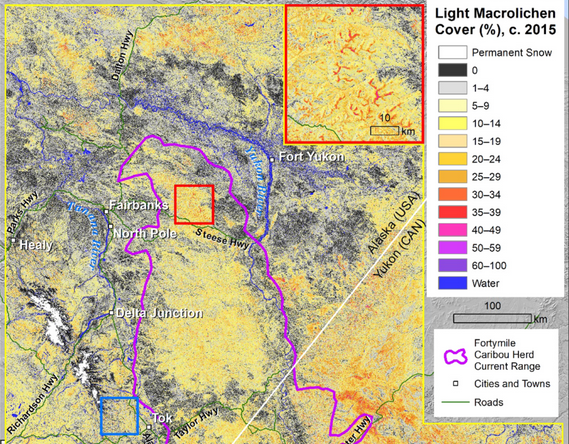
Federal
ABoVE: Burn Severity of Soil Organic Matter, Northwest Territories, Canada, 2014-2015
National Aeronautics and Space Administration —
This dataset provides maps at 30-m resolution of landscape surface burn severity (surface litter and soil organic layers) from the 2014-2015 fires in the Northwest... -
Federal
ACCLIP WB-57 Aircraft In-situ Cloud Data
National Aeronautics and Space Administration —
ACCLIP_Cloud_AircraftInSitu_WB57_Data is the in-situ cloud data collection during the Asian Summer Monsoon Chemical & Climate Impact Project (ACCLIP). Data from... -
Federal
ABoVE: Soil Temperature Profiles, USArray Seismic Stations, AK and Canada, 2016-2019
National Aeronautics and Space Administration —
This dataset includes soil temperature profile measurements taken at 16 monitoring sites in Alaska, USA, and at one site in Yukon, Canada. The six sites are... -
Federal
Planck-ATCA Co-eval Observations (PACO) Project Bright Sample Catalog
National Aeronautics and Space Administration —
The Planck Australia Telescope Compact Array (Planck-ATCA) Co-eval Observations (PACO) have provided flux density measurements of well-defined samples of Australia... -
Federal
Earth Radiation Budget Experiment (ERBE) S-9 Scanner Radiant Flux
National Aeronautics and Space Administration —
ERBE_S9_NAT is the Earth Radiation Budget Experiment (ERBE) S-9 Scanner Radiant Flux data set. It contains inverted daily, monthly hourly, and monthly averages of... -
Federal
FIFE CDROM Vol. 3 Contents: NS001 Thematic Mapper Simulator (TMS) Imagery, 1987-1989
National Aeronautics and Space Administration —
This data set provides aircraft-based NS001 Thematic Mapper Simulator (TMS) images of the study area associated with The First ISLSCP (International Satellite Land... -
Federal
Calculated Leaf Carbon and Nitrogen, 1992 (ACCP)
National Aeronautics and Space Administration —
The purpose of these measurements was to determine plot-level average leaf concentrations of nitrogen, lignin, cellulose, etc. in order to investigate how AVIRIS... -
Federal
CAMEX-4 AMPR BRIGHTNESS TEMPERATURE (TB) V1
National Aeronautics and Space Administration —
The CAMEX-4 AMPR Brightness Temperature (TB) dataset was collected by the Advanced Microwave Precipitation Radiometer (AMPR), which was deployed during the Fourth... -
Federal
NGC 4472 Chandra X-Ray Point Source Catalog
National Aeronautics and Space Administration —
The Chandra X-Ray Point Source Catalog of the giant elliptical galaxy NGC 4472 contains the results of a Chandra ACIS-S/Hubble Space Telescope (HST) study of the... -
State
Utility-Scale Renewable Generation Totals by County: 2024
State of California —
Power plants with a capacity of at least 1 MW are included in totals. Counties with nosymbol have no utility-scale renewable electric generation. Distributed... -
Federal
MLS/Aura Level 3 Daily Binned Relative Humidity With Respect To Ice (RHI) on Zonal and Similar Grids V004 (ML3DZRHI) at GES DISC
National Aeronautics and Space Administration —
ML3DZRHI is the EOS Aura Microwave Limb Sounder (MLS) daily binned on zonal and assorted vertical grids product for relative humidity with respect to ice (RHI)... -
Federal
MISR Level 3 Global Cloud public Product in netCDF format covering a day V002
National Aeronautics and Space Administration —
MI3DCLDN_2 is the Multi-angle Imaging SpectroRadiometer (MISR) Level 3 Global Cloud public Product in netCDF format covering a day version 2. It contains the public... -
Federal
MISR Level 3 FIRSTLOOK Component Global Albedo product covering a day V002
National Aeronautics and Space Administration —
MI3DALF_002 is the Multiangle Imaging SpectroRadiometer (MISR) Level 3 FIRST LOOK Component Global Albedo product covering a day version 2. It is intended to be used... -
Federal
Measurement of Air Pollution from Satellites (MAPS) Space Radar Laboratory - 1 (SRL1) Carbon Monoxide Second by Second data
National Aeronautics and Space Administration —
MAPS Overview The MAPS experiment measures the global distribution of carbon monoxide (CO) mixing ratios in the free troposphere. Because of MAPS' previous flights on... -
Federal
MODIS/Terra+Aqua BRDF/Albedo QA LocalSolarNoon Daily L3 Global 30ArcSec CMG V006
National Aeronautics and Space Administration —
The MCD43D32 Version 6 data product was decommissioned on July 31, 2023. Users are encouraged to use the MCD43D32 Version 6.1 data product.The MCD43D32 Version 6...

Official websites use .gov
A
.gov website belongs to an official government
organization in the United States.
Secure .gov websites use HTTPS
A
lock (
) or https:// means you’ve safely connected to
the .gov website. Share sensitive information only on official,
secure websites.