
-
Federal
BOREAS TE-05 Diurnal CO2 Canopy Profile Data
National Aeronautics and Space Administration —
These data were collected by BOREAS TE-05 to provide detailed information within the canopy during times when TE-05 sampled canopy CO2 for carbon and oxygen isotope... -
Federal
BOREAS Daedalus TMS Level-0 Imagery: Digital Counts in BIL Format
National Aeronautics and Space Administration —
The level-0 Daedalus TMS imagery, along with the other remotely sensed images, was collected to provide spatially extensive information about radiant energy over the... -
Federal
BOREAS Agriculture Canada Central Saskatchewan Vector Soils Data, R1
National Aeronautics and Space Administration —
This data set provides soil descriptions for forested areas in the BOREAS southern study area (SSA) in central Saskatchewan, Canada provided by Agriculture Canada.... -
Federal
BOREAS AFM-06 Surface Meteorological Data
National Aeronautics and Space Administration —
The BOREAS AFM-06 team from the National Oceanic and Atmospheric Administration Environment Technology Laboratory (NOAA/ETL) collected surface meteorological data... -
Federal
BOREAS AFM-06 Mean Wind Profile Data
National Aeronautics and Space Administration —
The BOREAS AFM-06 team from the National Oceanic and Atmospheric Administration Environment Technology Laboratory (NOAA/ETL) operated a 915 MHz wind/Radio Acoustic... -
Federal
ATom: In Situ Data from Caltech Chemical Ionization Mass Spectrometer (CIT-CIMS), V2
National Aeronautics and Space Administration —
This dataset provides the concentrations of gas-phase organic and inorganic analytes measured by the California Institute of Technology (CIT) Chemical Ionization Mass... -
Federal
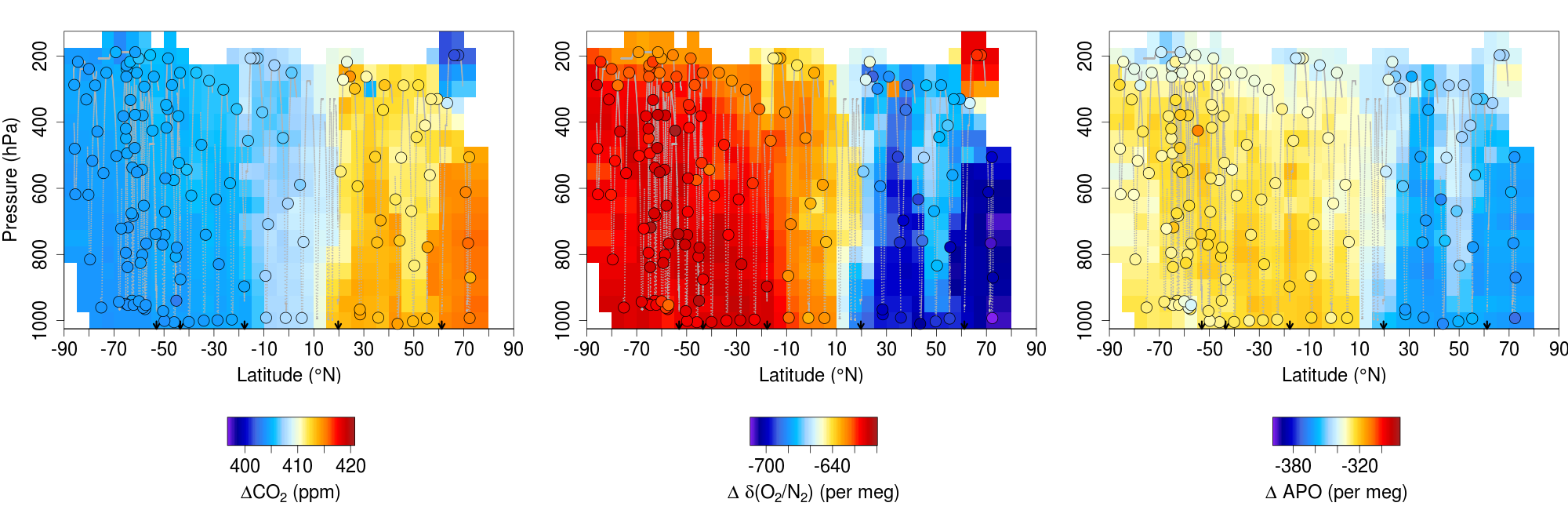
ATom: L2 In Situ Measurements from the NCAR Airborne Oxygen Instrument (AO2), V2
National Aeronautics and Space Administration —
This dataset provides in situ atmospheric oxygen and carbon dioxide concentrations measured by the NCAR Airborne Oxygen Instrument (AO2) during airborne campaigns... -
Federal
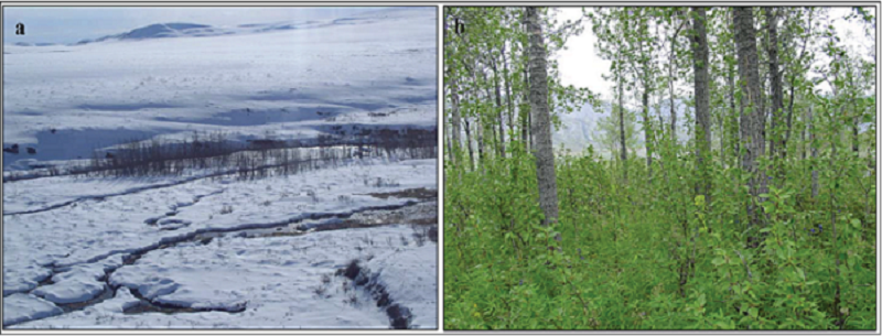
Arctic Vegetation Plots, Poplars, Arctic and Interior AK and YT, Canada, 2003-2005
National Aeronautics and Space Administration —
This data set provides vegetation cover and environmental plot data collected from 32 balsam poplar (Populus balsamifera L., Salicaceae) vegetation plots located on... -
Federal
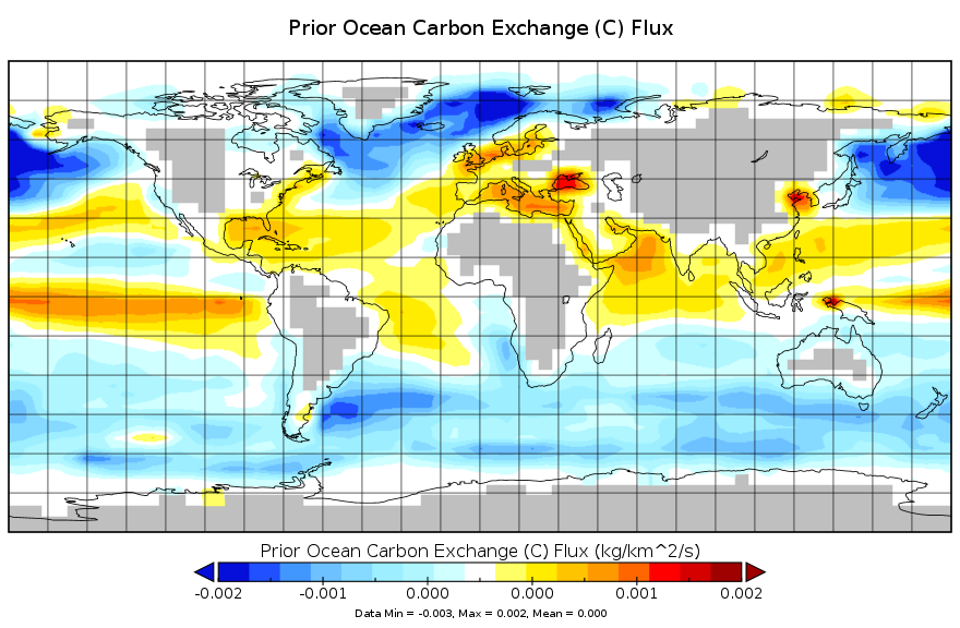
Carbon Monitoring System Carbon Flux for Ocean Prior L4 V2 (CMSFluxOceanPrior) at GES DISC
National Aeronautics and Space Administration —
This dataset provides the Carbon Flux for Ocean Carbon Prior.The NASA Carbon Monitoring System (CMS) is designed to make significant contributions in characterizing,... -
Federal
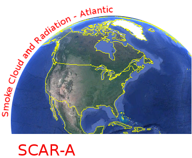
CAR SCAR-A Sulfates, Clouds, and Radiation-Atlantic L1 V1 (CAR_SCARA_L1C) at GES DISC
National Aeronautics and Space Administration —
The objectives for the SCAR mission are to advance our knowledge of how the physical, chemical and radiative processes in our atmosphere are affected by sulfate... -
Federal
Carbon Monitoring System Carbon Flux FossilFuel Prior L4 V3 (CMSFluxFossilFuelPrior)
National Aeronautics and Space Administration —
This dataset provides the Prior for the Fossil Fuel Carbon Flux.The NASA Carbon Monitoring System (CMS) is designed to make significant contributions in... -
Federal
CAR SnowEx17 Snow Mass and Energy Measurements L1 V1 (CAR_SNOWEX17_L1C) at GES DISC
National Aeronautics and Space Administration —
SnowEx is a multi-year airborne project to help advance capabilities, and plan for a near-future space mission to monitor global seasonal snow water equivalent —... -
Federal
CALIPSO Lidar Level 2 Vertical Feature Mask (VFM), V4-51
National Aeronautics and Space Administration —
CAL_LID_L2_VFM-Standard-V4-21 is the Cloud-Aerosol Lidar and Infrared Pathfinder Satellite Observations (CALIPSO) Lidar Level 2 Vertical Feature Mask (VFM), Version... -
Federal
CALIPSO Lidar Level 2 Vertical Feature Mask (VFM), V4-20
National Aeronautics and Space Administration —
CAL_LID_L2_VFM-Standard-V4-20 is the Cloud-Aerosol Lidar and Infrared Pathfinder Satellite Observations (CALIPSO) Lidar Level 2 Vertical Feature Mask (VFM), Version... -
Federal
CALIPSO Lidar Level 3 Stratospheric Aerosol Profiles Standard V1-01
National Aeronautics and Space Administration —
CAL_LID_L3_Stratospheric_APro-Standard-V1-01 is the Cloud-Aerosol Lidar and Infrared Pathfinder Satellite Observation (CALIPSO) Lidar Level 3 Stratospheric Aerosol... -
Federal
BOREAS TE-09 Leaf Biochemistry Averages
National Aeronautics and Space Administration —
The BOREAS TE-09 team collected several data sets related to chemical and photosynthetic properties of leaves. This data set contains canopy biochemistry data... -
Federal
BOREAS TE-08 Aspen Bark Chemistry Data
National Aeronautics and Space Administration —
The BOREAS TE-08 team collected pigment density data from aspen bark and leaves from four sites within the BOREAS SSA from 24-May-1994 to 16-Jun-1994 (IFC-1),... -
Federal
BOREAS Level-0 AOCI Imagery: Digital Counts in BIL Format
National Aeronautics and Space Administration —
The level-0 AOCI imagery, along with the other remotely sensed images, was collected to provide spatially extensive information about radiant energy over the primary... -
Federal
BOREAS Level-1B TIMS Imagery: At Sensor Radiance in BSQ Format
National Aeronautics and Space Administration —
The BOREAS Staff Science Aircraft Data Acquisition Program focused on providing the research teams with the remotely sensed satellite data products they needed to... -
Federal
BOREAS Landsat TM Level-3b Imagery: At-Sensor Radiance in BSQ Format
National Aeronautics and Space Administration —
For BOREAS, the level-3b Landsat TM data, along with the other remotely sensed images, were collected in order to provide spatially extensive information over the...

Official websites use .gov
A
.gov website belongs to an official government
organization in the United States.
Secure .gov websites use HTTPS
A
lock (
) or https:// means you’ve safely connected to
the .gov website. Share sensitive information only on official,
secure websites.