

253 datasets found for "Libraries"
-
State
Geothermal Resource Potential by Field
State of California —
This data layer contains geothermal resource areas and their technical potential used in long-term electric system modeling for Integrated Resource Planning and SB... -
State
California Least Tern Monitoring Sites Generalized - CDFW [ds3146]
State of California —
California least tern colonies are monitored during nesting season along the California Coast and data is reported to California Department of Fish and Wildlife. The... -
City
ECA Wetlands
City of Seattle —
Displays areas with wetlands in the City of Seattle.A polygon feature class showing wetlands, which are those areas that are inundated or saturated by surface water... -
City
City Property Primary Jurisdiction
City of Seattle —
Displays data from CTYPROP.RPAMIS_PMA_JOIN. Symbolized on the attribute JURIS_DEPT.Updated weekly.LABELJURIS_DEPTSeattle CenterCEN, SEADept. of NeighborhoodsDONParks... -
Federal
AHHS Dust PFAS NTA Negative Mode 3-28-25
U.S. Environmental Protection Agency —
This information comes from the dataset README covering the NTA data and associated metadata for this dataset. Dust samples were collected from home vacuum bags and... -
State
California Least Tern Monitoring Sites Generalized - CDFW [ds3146] Extended Table
State of California —
California least tern colonies are monitored during nesting season along the California Coast and data is reported to California Department of Fish and Wildlife. The... -
Federal
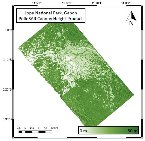
AfriSAR: Rainforest Canopy Height Derived from PolInSAR and Lidar Data, Gabon
National Aeronautics and Space Administration —
This dataset provides estimates of forest canopy height and canopy height uncertainty for study areas in the Pongara National Park and the Lope National Park, Gabon.... -
City
ECA Known Slide Scarps
City of Seattle —
Displays areas of landslide events based on a Seattle Landslide Study completed by Shannon and Wilson.A polygon feature class showing landslide event inventory. Used... -
Federal
All CGP Records (MARC XML)
Government Publishing Office (GPO) —
The U.S. Government Publishing Office (GPO) makes available for free an annual snapshot of all MARC bibliographic records in the Catalog of U.S. Government... -
Federal
George Washington Carver National Memorial FFI Fire Effects Monitoring Data
Department of the Interior —
Fire effects monitoring data collected at George Washington Carver National Monument in Diamond, MO. The data were collected during spring, summer, and fall field... -
Federal
temo: teqp-based Thermodynamic Model Optimization
National Institute of Standards and Technology —
This library make the process of fitting highly accurate thermodynamic mixture models much easier, facilitating their use by a large swath of the community. A modular... -
Federal
Analysis, Modeling, and Simulation (AMS) Testbed Development and Evaluation to Support Dynamic Mobility Applications (DMA) and Active Transportation and Demand Management (ATDM) Programs: calibration Report for Phoenix Testbed [supporting datasets]
Department of Transportation —
The datasets in this zip file are in support of FHWA-JPO-16-379, Analysis, Modeling, and Simulation (AMS) Testbed Development and Evaluation to Support Dynamic... -
State
Washington Library Locations
State of Washington —
This asset lists locations of various types of libraries in Washington State, including public, academic, medical, law, government and tribal libraries. -
Federal
Demonstration of dispersion gas barometry
National Institute of Standards and Technology —
Supplemental material to the 2025 article "Demonstration of dispersion gas barometry" by Y. Yang, J.A. Stone, and P.F. Egan.The archive file contains two-color data... -
Federal
Data from: A High-Quality Genome Assembly from a Single, Field-collected Spotted Lanternfly (Lycorma delicatula) using the PacBio Sequel II System
Department of Agriculture —
A high-quality reference genome is an essential tool for applied and basic research on arthropods. Long-read sequencing technologies may be used to generate more... -
State
RegMapsLinks 20251120
State of California —
The Alquist-Priolo Earthquake Fault Zoning Act (1972) and the Seismic Hazards Mapping Act (1990) direct the State Geologist to delineate regulatory "Zones of Required... -
Federal
AHHS Dust PFAS NTA
U.S. Environmental Protection Agency —
This information comes from the dataset README covering the NTA data and associated metadata for this dataset. Dust samples were collected from home vacuum bags and... -
City
Louisville Metro KY Areas of Interest
Louisville Metro Government —
Types of areas include industrial parks, significant cemeteries, airports, tourist sites, major manufacturing complexes, major malls, parks not maintained by the... -
Federal
NIST/NIBIB Medical Imaging Phantom Lending Library
National Institute of Standards and Technology —
This database contains imaging and calibration data for phantoms contained in the NIST/NIBIB Phantom Lending Library (PLL). Description and access to the PLL can be...
253 datasets found for "Libraries"