
-
Federal
BOREAS TF-02 SSA-OA Tower Flux, Meteorological, and Precipitation Data
National Aeronautics and Space Administration —
The BOREAS TF-02 team collected energy, carbon dioxide, water vapor, and momentum flux data above the canopy and in profiles through the canopy, along with... -
Federal
BOREAS TF-04 CO2 and CH4 Chamber Flux Data from the SSA
National Aeronautics and Space Administration —
The BOREAS TF-04 team measured fluxes of carbon dioxide (CO2) and methane (CH4) across the soil-air interface in four ages of jack pine forest at the Southern Study... -
Federal
BOREAS AFM-05 Level-2 Upper Air Network Standard Pressure Level Data
National Aeronautics and Space Administration —
The BOREAS AFM-05 team collected and processed data from the numerous radiosonde flights during the project. The goals of the AFM-05 team were to provide large scale... -
Federal
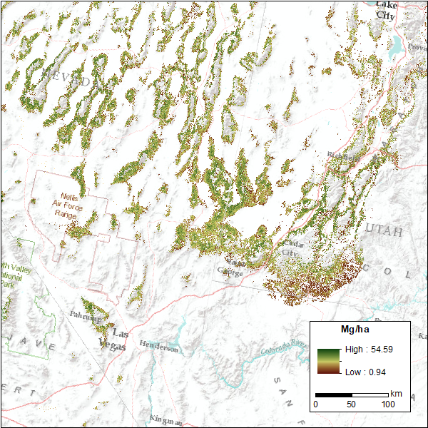
CMS: Pinyon-Juniper Forest Live Aboveground Biomass, Great Basin, USA, 2000-2016
National Aeronautics and Space Administration —
This dataset provides annual maps of live aboveground tree biomass (Mg/ha) for pinyon-juniper forests across the Great Basin of the Western USA for the years... -
Federal
CERES Regionally Averaged TOA Fluxes, Clouds and Aerosols Hourly NOAA-20 Edition 1B
National Aeronautics and Space Administration —
The Clouds and the Earth's Radiant Energy System (CERES) Single Scanner Footprint One Degree (SSF1deg) Hour provides regional averages of CERES Top of Atmosphere... -
Federal
CERES Single Scanner Footprint (SSF) TOA/Surface Fluxes, Clouds and Aerosols Aqua-FM3 Edition4A
National Aeronautics and Space Administration —
CER_SSF_Aqua-FM3-MODIS_Edition4A is the Clouds and the Earth's Radiant Energy System (CERES) Single Scanner Footprint (SSF) Top-of-the-Atmosphere (TOA)/Surface... -
Federal
CERES Monthly Gridded Single Satellite Fluxes and Clouds Terra FM2 Edition2C
National Aeronautics and Space Administration —
CER_FSW_Terra-FM2-MODIS_Edition2C is the Clouds and the Earth's Radiant Energy System (CERES) Fixed Swath Width (FSW) Monthly Gridded Single Satellite Fluxes (SSF)... -
Federal
CERES Regionally Averaged TOA Fluxes, Clouds and Aerosols Hourly NOAA-20 Edition 1C
National Aeronautics and Space Administration —
CER_SSF1deg-Hour_NOAA20-VIIRS_Edition1C is the NOAA-20 Clouds and the Earth's Radiant Energy System (CERES) Level 3 Single Scanner Footprint (SSF) Edition1C observed... -
Federal
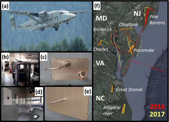
CARAFE: Regional Airborne Greenhouse Gases Eddy Covariance Measurements, 2016-2017
National Aeronautics and Space Administration —
This dataset provides airborne eddy covariance (EC) fluxes of carbon dioxide, methane, sensible heat, and latent heat at high spatial resolution collected during the... -
Federal
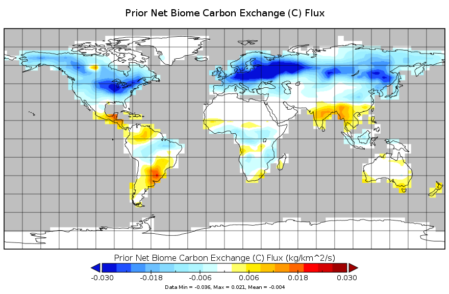
Carbon Monitoring System Carbon Flux from the Net Biome Exchange Prior L4 V2 (CMSFluxNBEPrior) at GES DISC
National Aeronautics and Space Administration —
This dataset provides the Carbon Flux from the Net Biome Exchange Prior.The NASA Carbon Monitoring System (CMS) is designed to make significant contributions in... -
Federal
CALIPSO Lidar Level 2 1/3 km Merged Layer, V4-51
National Aeronautics and Space Administration —
CAL_LID_L2_333mMLay-Standard-V4-51 is the Cloud-Aerosol Lidar and Infrared Pathfinder Satellite Observation (CALIPSO) Lidar Level 2 333 m Merged (cloud + aerosol)... -
Federal
CALIPSO Lidar Level 2 5 km Cloud Layer, V4-20
National Aeronautics and Space Administration —
CAL_LID_L2_05kmCLay-Standard-V4-20 is the Cloud-Aerosol Lidar and Infrared Pathfinder Satellite Observations (CALIPSO) Lidar Level 2 5 km Cloud Layer, Version 4-20... -
Federal
CALIPSO Lidar Level 2 5 km Aerosol Layer Data, V4-20
National Aeronautics and Space Administration —
CAL_LID_L2_05kmALay-Standard-V4-20 is the Cloud-Aerosol Lidar and Infrared Pathfinder Satellite Observation (CALIPSO) Lidar Level 2 5 km Aerosol Layer Data, Version... -
Federal
CALIPSO Lidar Level 2 5 km Merged Layer, V4-21
National Aeronautics and Space Administration —
CAL_LID_L2_05kmMLay-Standard-V4-21 is the Cloud-Aerosol Lidar and Infrared Pathfinder Satellite Observations (CALIPSO) Lidar Level 2 5 km Merged Layer, Version 4-21... -
Federal
BOREAS TGB-05 CO2, CH4, and CO Chamber Flux Data over the NSA
National Aeronautics and Space Administration —
The BOREAS TGB-05 team collected a variety of trace gas concentration and flux measurements at several NSA sites. This data set contains carbon dioxide (CO2), methane... -
Federal
BOREAS TGB-04 NSA-BVP Tower Flux and Meteorological Data
National Aeronautics and Space Administration —
The BOREAS TGB-04 team measured the exchange of heat, water, and CO2 between a boreal forest beaver pond and the atmosphere in the NSA for the ice-free period of... -
Federal
BOREAS TGB-01/TGB-03 NEE Data over the NSA Fen
National Aeronautics and Space Administration —
The BOREAS TGB-01 and TGB-03 teams collected several data sets that contributed to understanding the measured trace gas fluxes over sites in the NSA. This data set... -
Federal
BOREAS TE-06 Biomass and Foliage Area Data
National Aeronautics and Space Administration —
The BOREAS TE-06 team collected several data sets in support of its efforts to characterize and interpret information on the plant biomass, allometry, biometry,... -
Federal
BOREAS TE-05 Surface Meteorological & Radiation Data
National Aeronautics and Space Administration —
The BOREAS group TE-05 collected measurements in the NSA and SSA on gas exchange, gas composition and tree growth. Measurements of meteorological data, including air... -
Federal
BOREAS TE-05 Leaf Carbon Isotope Data
National Aeronautics and Space Administration —
The BOREAS group TE-05 collected measurements in the NSA and SSA on gas exchange, gas composition and tree growth. This documentation describes leaf carbon isotope...

Official websites use .gov
A
.gov website belongs to an official government
organization in the United States.
Secure .gov websites use HTTPS
A
lock (
) or https:// means you’ve safely connected to
the .gov website. Share sensitive information only on official,
secure websites.