
-
Federal
BOREAS TE-20 NSA Soil Lab Data
National Aeronautics and Space Administration —
This data set contains the major soil properties of soil samples collected at the tower flux sites in the NSA. The soil samples were collected by Hugo Veldhuis and... -
Federal
BOREAS TE-18 Biomass Density Image of the SSA
National Aeronautics and Space Administration —
This biomass density image covers almost the entire BOREAS SSA. The pixels for which biomass density is computed include areas that are in conifer land cover classes... -
Federal
BOREAS Level-3S SPOT Imagery: Scaled At-Sensor Radiance in LGSOWG Format
National Aeronautics and Space Administration —
For BOREAS, the level-3s SPOT data, along with the other remotely sensed images, were collected in order to provide spatially extensive information over the primary... -
Federal
BOREAS Level-4b AVHRR-LAC Ten-Day Composite Images: At-Sensor Radiance
National Aeronautics and Space Administration —
The BOREAS Staff Science Satellite Data Acquisition Program focused on providing the research teams with the remotely sensed satellite data products they needed to... -
Federal
BOREAS Level-3b AVHRR-LAC Imagery: Scaled At-Sensor Radiance in LGSOWG Format
National Aeronautics and Space Administration —
The BOREAS Staff Science Satellite Data Acquisition Program focused on providing the research teams with the remotely sensed satellite data products they needed to... -
Federal
BOREAS Level-2 MAS Surface Reflectance and Temperature Images in BSQ Format
National Aeronautics and Space Administration —
The BOREAS Staff Science Aircraft Data Acquisition Program focused on providing the research teams with the remotely sensed aircraft data products they needed to... -
Federal
BOREAS NS001 TMS Level-0 Images in BIL Format
National Aeronautics and Space Administration —
For BOREAS, the NS001 TMS imagery, along with the other remotely sensed images, was collected in order to provide spatially extensive information over the primary... -
Federal
Aspen Forest Cover by Stratum/Plot (SNF)
National Aeronautics and Space Administration —
The purpose of the Superior National Forest (SNF) study was to improve our understanding of the relationship between remotely sensed observations and important... -
Federal
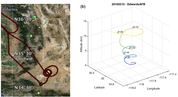
ASCENDS: Active Sensing of CO2 With AVOCET, California and Nevada, 2016
National Aeronautics and Space Administration —
This dataset provides in situ airborne measurements of atmospheric carbon dioxide (CO2) over California and Nevada on February 10-11, 2016. Measurements were taken... -
Federal
ASCENDS: Airborne CO2 LAS Retrieval, Indianapolis, IN, USA, 2014
National Aeronautics and Space Administration —
This dataset provides in situ airborne measurements of atmospheric carbon dioxide (CO2) over Indianapolis, Indiana (IN) on September 3, 2014 during the morning... -
Federal
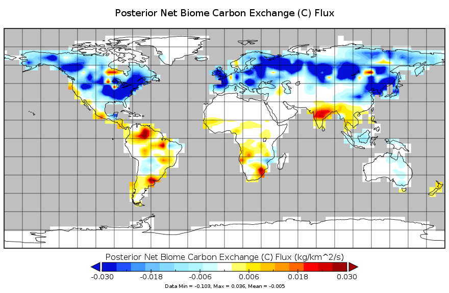
Carbon Monitoring System Carbon Flux from the Net Biome Exchange L4 V2 (CMSFluxNBE) at GES DISC
National Aeronautics and Space Administration —
This dataset provides the Carbon Flux from the Net Biome Exchange.The NASA Carbon Monitoring System (CMS) is designed to make significant contributions in... -
Federal
CALIPSO Lidar Level 3 Tropospheric Aerosol Profiles, Cloudy Sky Transparent Data, Standard V4-20
National Aeronautics and Space Administration —
CAL_LID_L3_Tropospheric_APro_CloudySkyTransparent-Standard-V4-20 is the Cloud-Aerosol Lidar and Infrared Pathfinder Satellite Observation (CALIPSO) Lidar Level 3... -
Federal
CALIPSO Wide Field Camera Level 1B 125m Native Science data, Validated Stage 1 V3-01
National Aeronautics and Space Administration —
CAL_WFC_L1_125m-ValStage1-V3-01 data are Cloud-Aerosol Lidar and Infrared Pathfinder Satellite Observation (CALIPSO) Wide Field Camera (WFC) Level 1B 125m Native... -
Federal
BOREAS/AES Campbell Scientific 15-minute Surface Meteorological Data: 1995
National Aeronautics and Space Administration —
Canadian AES personnel collected data related to surface and atmospheric meteorological conditions over the BOREAS Region. This data set contains 15 minute... -
Federal
BOREAS TE-12 Incoming PAR Through the Forest Canopy Data
National Aeronautics and Space Administration —
The BOREAS TE-12 team collected PAR data sets in support of its efforts to characterize and interpret information on shoot geometry, leaf optical properties, leaf... -
Federal
BOREAS TE-09 Photosynthetic Capacity and Foliage Nitrogen Data
National Aeronautics and Space Administration —
The BOREAS TE-09 team collected several data sets related to chemical and photosynthetic properties of leaves in boreal forest tree species. This data set describes... -
Federal
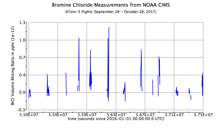
ATom: L2 Measurements from NOAA ToF Chemical Ionization Mass Spectrometer, Version 2
National Aeronautics and Space Administration —
This dataset provides the mixing ratios of reactive nitrogen and halogen species measured by the NOAA Iodide Ion Time-of-Flight Chemical Ionization Mass Spectrometer... -
Federal
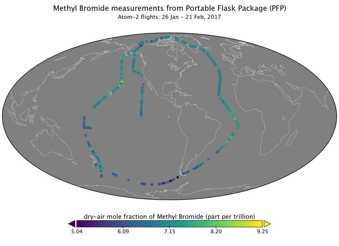
ATom: L2 Measurements from the Programmable Flask Package (PFP) Whole Air Sampler
National Aeronautics and Space Administration —
This dataset provides mole fractions of atmospheric trace gases measured by the Programmable Flask Package (PFP) Whole Air Sampler during airborne campaigns conducted... -
Federal
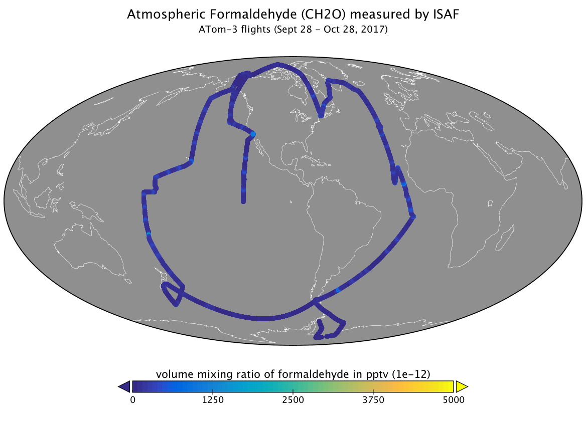
ATom: L2 Measurements of In Situ Airborne Formaldehyde (ISAF)
National Aeronautics and Space Administration —
This dataset provides the atmospheric volume mixing ratio of formaldehyde measured during airborne campaigns conducted by NASA's Atmospheric Tomography (ATom)... -
Federal
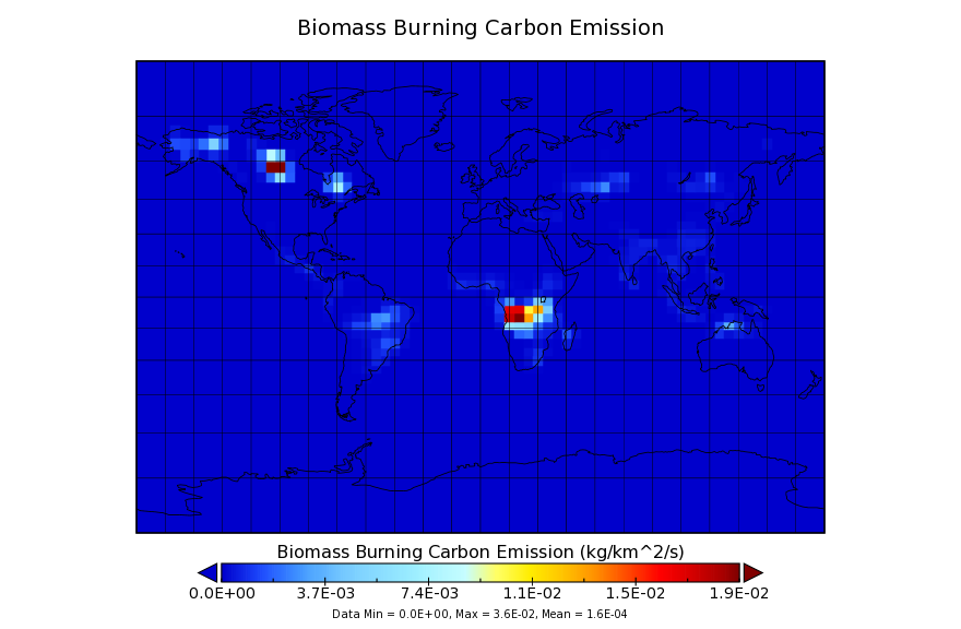
Carbon Monitoring System Carbon Flux for Fire L4 V1 (CMSFluxFire) at GES DISC
National Aeronautics and Space Administration —
This dataset provides the Carbon Flux for Fires.The NASA Carbon Monitoring System (CMS) is designed to make significant contributions in characterizing, quantifying,...

Official websites use .gov
A
.gov website belongs to an official government
organization in the United States.
Secure .gov websites use HTTPS
A
lock (
) or https:// means you’ve safely connected to
the .gov website. Share sensitive information only on official,
secure websites.