
-
Federal
BOREAS TF-10 NSA-YJP Tower Flux, Meteorological, and Porometry Data
National Aeronautics and Space Administration —
The BOREAS TF-10 team collected tower flux and meteorological data at two sites, a fen and a young jack pine forest, near Thompson, Manitoba, Canada, as part of... -
Federal
BOREAS RSS-07 LAI, Gap Fraction, and FPAR Data
National Aeronautics and Space Administration —
The BOREAS RSS-07 team collected various data sets to develop and validate an algorithm to allow the retrieval of the spatial distribution of LAI from remotely sensed... -
Federal
BOREAS HYD-08 1994 Gravimetric Moss Moisture Data
National Aeronautics and Space Administration —
The BOREAS HYD-08 team made measurements of surface hydrological processes that were collected at the NSA OBS Tower Flux site in 1994 and at Joey Lake, Manitoba, to... -
Federal
BOREAS AFM-04 Twin Otter Aircraft Sounding Data
National Aeronautics and Space Administration —
The BOREAS AFM-04 team used the NRC Twin Otter aircraft to make sounding measurements through the boundary layer. These measurements included concentrations of carbon... -
Federal
Arctic Vegetation Plots Legacy Project Barter Island and Point Barrow, Alaska, 1994
National Aeronautics and Space Administration —
This dataset provides vegetation cover and environmental plot and soil data collected at two U.S. Air Force sites at Barter Island (BI) and Point Barrow (B), on the... -
Federal
CALIPSO Lidar Level 3 Tropospheric Aerosol Profiles, Cloudy Sky Opaque Data, Standard V4-21
National Aeronautics and Space Administration —
CAL_LID_L3_Tropospheric_APro_CloudySkyOpaque-Standard-V4-21 is the Cloud-Aerosol Lidar and Infrared Pathfinder Satellite Observation (CALIPSO) Lidar Level 3... -
Federal
CALIPSO Lidar Level 3 Tropospheric Aerosol Profiles, All Sky Data, Standard V4-21
National Aeronautics and Space Administration —
CAL_LID_L3_Tropospheric_APro_AllSky-Standard-V4-21 is the Cloud-Aerosol Lidar and Infrared Pathfinder Satellite Observation (CALIPSO) Lidar Level 3 Tropospheric... -
Federal
BOREAS TGB-08 Photosynthetic Rate Data over the SSA-OBS and the SSA-OJP
National Aeronautics and Space Administration —
The TGB-08 team collected data to investigate the controls over non-methane hydrocarbon (NMHC) fluxes from boreal forest tree species. This data set includes... -
Federal
BOREAS TE-20 NSA Soil Lab Data
National Aeronautics and Space Administration —
This data set contains the major soil properties of soil samples collected at the tower flux sites in the NSA. The soil samples were collected by Hugo Veldhuis and... -
Federal
BOREAS TE-18 Biomass Density Image of the SSA
National Aeronautics and Space Administration —
This biomass density image covers almost the entire BOREAS SSA. The pixels for which biomass density is computed include areas that are in conifer land cover classes... -
Federal
BOREAS Level-3S SPOT Imagery: Scaled At-Sensor Radiance in LGSOWG Format
National Aeronautics and Space Administration —
For BOREAS, the level-3s SPOT data, along with the other remotely sensed images, were collected in order to provide spatially extensive information over the primary... -
Federal
BOREAS Level-4b AVHRR-LAC Ten-Day Composite Images: At-Sensor Radiance
National Aeronautics and Space Administration —
The BOREAS Staff Science Satellite Data Acquisition Program focused on providing the research teams with the remotely sensed satellite data products they needed to... -
Federal
BOREAS Level-3b AVHRR-LAC Imagery: Scaled At-Sensor Radiance in LGSOWG Format
National Aeronautics and Space Administration —
The BOREAS Staff Science Satellite Data Acquisition Program focused on providing the research teams with the remotely sensed satellite data products they needed to... -
Federal
BOREAS Level-2 MAS Surface Reflectance and Temperature Images in BSQ Format
National Aeronautics and Space Administration —
The BOREAS Staff Science Aircraft Data Acquisition Program focused on providing the research teams with the remotely sensed aircraft data products they needed to... -
Federal
BOREAS Level-1B MAS Imagery: At-Sensor Radiance, Relative X and Y Coordinates
National Aeronautics and Space Administration —
For BOREAS, the MAS images, along with the other remotely sensed data, were collected to provide spatially-extensive information over the primary study areas. This... -
Federal
BOREAS Landsat TM Level-3p Imagery: Geocoded and Scaled At-Sensor Radiance
National Aeronautics and Space Administration —
For BOREAS, the level-3p Landsat TM data were used to supplement the level-3s Landsat TM products. Along with the other remotely sensed images, the Landsat TM images... -
Federal
BOREAS NS001 TMS Level-0 Images in BIL Format
National Aeronautics and Space Administration —
For BOREAS, the NS001 TMS imagery, along with the other remotely sensed images, was collected in order to provide spatially extensive information over the primary... -
Federal
Aspen Forest Cover by Stratum/Plot (SNF)
National Aeronautics and Space Administration —
The purpose of the Superior National Forest (SNF) study was to improve our understanding of the relationship between remotely sensed observations and important... -
Federal
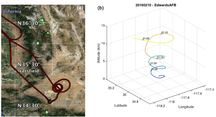
ASCENDS: Active Sensing of CO2 With AVOCET, California and Nevada, 2016
National Aeronautics and Space Administration —
This dataset provides in situ airborne measurements of atmospheric carbon dioxide (CO2) over California and Nevada on February 10-11, 2016. Measurements were taken... -
Federal
ASCENDS: Airborne CO2 LAS Retrieval, Indianapolis, IN, USA, 2014
National Aeronautics and Space Administration —
This dataset provides in situ airborne measurements of atmospheric carbon dioxide (CO2) over Indianapolis, Indiana (IN) on September 3, 2014 during the morning...

Official websites use .gov
A
.gov website belongs to an official government
organization in the United States.
Secure .gov websites use HTTPS
A
lock (
) or https:// means you’ve safely connected to
the .gov website. Share sensitive information only on official,
secure websites.