
-
Federal
Aircraft Flux-Detrended: U of Wy. (FIFE)
National Aeronautics and Space Administration —
The University of Wyoming (UW) King Air atmospheric boundary layer measurement missions were flown in 1987 during IFCs 3 and 4. This Boundary Layer Fluxes data set... -
Federal
AirMOSS: L1 S-0 Polarimetric Data from AirMOSS P-band SAR, BERMS, Canada, 2012-2015
National Aeronautics and Space Administration —
This data set provides level 1 (L1) polarimetric radar backscattering coefficient (sigma-0), multilook complex, polarimetrically calibrated, and georeferenced data... -
Federal
AirMOSS: L1 S-0 Polarimetric Data from AirMOSS P-band SAR, MOISST, 2012-2015
National Aeronautics and Space Administration —
This data set provides level 1 (L1) polarimetric radar backscattering coefficient (sigma-0), multilook complex, polarimetrically calibrated, and georeferenced data... -
Federal
Airborne Multi-angle Imaging SpectroRadiometer (AirMISR) Data from the Snow and Ice 2001 Campaign
National Aeronautics and Space Administration —
The AIRMISR_SNOW_ICE_2001 data were acquired during the Colorado snow albedo field experiment in the Yampa Valley of Colorado during February and March, 2001. This... -
Federal
Airborne Precipitation Radar 3rd Generation (APR-3) CPEX-AW
National Aeronautics and Space Administration —
The Airborne Precipitation Radar 3rd Generation (APR-3) CPEX-AW dataset consists of radar reflectivity, Doppler velocity for all bands, linear depolarization ratio... -
Federal
Mobile Harbor Navigation Channel Delft3D Model Inputs and Results - Initial Existing Conditions Grid
Department of the Interior —
The numerical model Delft3D (developed by Deltares) was developed to evaluate the potential effects of proposed navigation channel deepening and widening in Mobile... -
Federal
Alaska's Changing YK Delta: Knowledge Exchange between Elders and Geoscientists, 2018
National Aeronautics and Space Administration —
This dataset provides a booklet documenting the discussions and outcomes from a knowledge-exchange meeting with Yup'ik elders from the Yukon-Kuskokwim Delta (YKD),... -
Federal
AirMOSS: L1 S-0 Polarimetric Data from AirMOSS P-band SAR, Howland Forest, 2012-2015
National Aeronautics and Space Administration —
This data set provides level 1 (L1) polarimetric radar backscattering coefficient (sigma-0), multilook complex, polarimetrically calibrated, and georeferenced data... -
Federal
Aircraft Flux-Filtered: Univ. Col. (FIFE)
National Aeronautics and Space Administration —
The NCAR King Air participation in FIFE-1987 and FIFE-1989 was part of a coordinated atmospheric boundary layer component which included other aircraft, surface... -
Federal
AirMOSS: L4 Modeled Volumetric Root Zone Soil Moisture, 2012-2015
National Aeronautics and Space Administration —
This data set provides hourly gridded soil moisture estimates derived from hydrologic modeling at nine AirMOSS sites across North America. The AirMOSS L4 RZSM product... -
Federal
Aircraft Flux-Raw: U of Wy. (FIFE)
National Aeronautics and Space Administration —
The University of Wyoming (UW) King Air atmospheric boundary layer measurement missions were flown in 1987 during IFCs 3 and 4. This Raw Boundary Layer Fluxes data... -
Federal
Compound 528616: N-methylcyclopropanecarboxamide
U.S. Department of Health & Human Services —
Chemical compound data from PubChem database. IUPAC Name: N-methylcyclopropanecarboxamide. Molecular Formula: C5H9NO. Molecular Weight: 99.13. This dataset contains... -
Federal
Airborne Multi-angle Imaging SpectroRadiometer (AirMISR) Data from the Bartlett 2003 Campaign
National Aeronautics and Space Administration —
The AIRMISR_BARTLETT_2003 data were acquired during a flight over the Bartlett Experimental Forest, New Hampshire, USA, target as part of the AirMISR deployments from... -
Federal
Soil-Water-Balance model data sets for the Interstate 94 corridor surficial aquifer, Clearwater to Elk River, Minnesota, 2010-2014
Department of the Interior —
A soil-water balance model (SWB) was developed to estimate potential recharge to the Interstate 94 Corridor surficial aquifer, located in central Minnesota, for the... -
Federal
Compound 527598: 4-Penten-1-ol, chloroacetate
U.S. Department of Health & Human Services —
Chemical compound data from PubChem database. IUPAC Name: pent-4-enyl 2-chloroacetate. Molecular Formula: C7H11ClO2. Molecular Weight: 162.61. This dataset contains... -
Federal
AirMOSS: L2 Hourly Precipitation at AirMOSS Sites, 2011-2015
National Aeronautics and Space Administration —
This data set provides level 2 (L2) calibrated hourly precipitation (cm/hr) from rain gauges at seven North American sites as part of the Airborne Microwave... -
Federal
AirMOSS: L1 S-0 Polarimetric Data from AirMOSS P-band SAR, Chamela, Mexico, 2012-2015
National Aeronautics and Space Administration —
This data set provides level 1 (L1) polarimetric radar backscattering coefficient (sigma-0), multilook complex, polarimetrically calibrated, and georeferenced data... -
Federal
Species distribution model (SDM) for Chylismia brevipes in the Mojave Desert
Department of the Interior —
Preserving native species diversity is fundamental to ecosystem conservation. Selecting appropriate native species for use in restoration is a critical component of... -
Federal
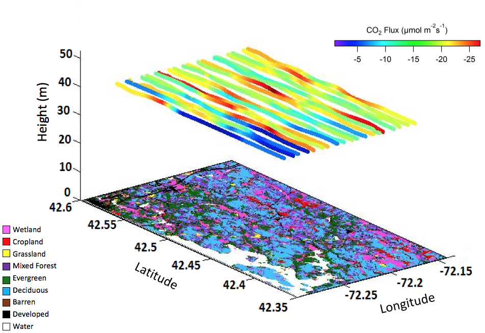
AirMOSS: L2 Airborne Carbon Flux at Selected AirMOSS Sites, 2012-2014
National Aeronautics and Space Administration —
This data set contains carbon flux measurements recorded by an aircraft at the Duke, Harvard, and Howland Forest sites during the summers of 2012-2014 as part of the... -
Federal
TIGER/Line Shapefile, 2022, County, Skagway Municipality, AK, Address Ranges Relationship File
U.S. Census Bureau, Department of Commerce —
The TIGER/Line shapefiles and related database files (.dbf) are an extract of selected geographic and cartographic information from the U.S. Census Bureau's Master...

Official websites use .gov
A
.gov website belongs to an official government
organization in the United States.
Secure .gov websites use HTTPS
A
lock (
) or https:// means you’ve safely connected to
the .gov website. Share sensitive information only on official,
secure websites.