

2,273 datasets found for "BG真人和AG真人的区别✅澳门葡京赌场官方网站-网址【079.one】㊙️最火爆PG电子超高爆奖率,注册即送38元.ljkidVptaiG"
-
City
2010 Traffic Flow Counts
City of Seattle —
Displays vehicle traffic volumes for arterial streets in Seattle based on spot studies that have been adjusted for seasonal variation. Data is a one time snapshot for... -
State
California Overlapping Cities and Counties and Identifiers with Coastal Buffers
State of California —
WARNING: This is a pre-release dataset and its fields names and data structures are subject to change. It should be considered pre-release until the end of 2024.... -
City
Seattle Public Libraries
City of Seattle —
Seattle Public Library offers books and media in locations throughout the city. Please see website for more information.Each branch has website link, please use for... -
Federal
New York State Energy Research and Development Authority Exterior Building Solutions To Insulation
Department of Energy —
TO4 8.2.2: Space Cond. for Deep Energy Retrofits The purpose of this project for the New York State Energy Research and Development Authority (NYSERDA) is to find new... -
Federal
Washington State Play Fairway Analysis - Passive Monitoring of St. Helens Shear Zone for Tomography and Precision Microseismic Event Detection
Department of Energy —
Data resources were derived from a passive seismic survey of the northern St. Helens Shear Zone on geothermal leases 12-24 km north of Mount St. Helens for phase 2 of... -
Federal
Evaluation of the Performance of Houses With and Without Supplemental Dehumidification in a Hot-Humid Climate
Department of Energy —
Understanding indoor humidity conditions in low energy homes in hot-humid climates is critical to promoting long term occupant comfort, indoor air quality and... -
Federal
Great Smoky Mountains National Park Elk Exclosure Vegetation Monitoring
Department of the Interior —
This database contains all long-term vegetation monitoring data related to elk (Cervus elaphus) reintroduction and management in GRSM. Each vegetation plot consists... -
Federal
Phage Data
U.S. Environmental Protection Agency —
Phage Data. This dataset is associated with the following publication: Zepp, R., M. Cyterski, K. Wong , O. Georgacopoulos, B. Acrey, G. Whelan, R. Parmar, and M.... -
Federal
SARP 2017 Data
National Aeronautics and Space Administration —
SARP_2017_Data is the data collected onboard the Wallops C-23 aircraft during the 2017 deployment of the Student Airborne Research Program (SARP) mission. Data... -
City
Speed Humps
City of Seattle —
Speed humps which are in street paved mounds used in low volume arterial streets and on non-arterial streets that have been designated as emergency fire routes. The... -
Federal
Soils Data for North Dakota Mined Land Reclamation Experiments in the 1970’s Using Soil Respreading
Department of Agriculture —
In the early 1970’s, it was determined that the most feasible way to reclaim lands disturbed by coal surface mining in the Northern Great Plains region was through... -
Federal
2015-16 International Baccalaureate Enrollment Estimations
Department of Education —
This Excel file contains data on student enrollment in International Baccalaureate (IB) programs for all states. The file contains three spreadsheets: total students,... -
Safe Passage Routes
District of Columbia —
The Office of the Deputy Mayor for Public Safety and Justice (DMPSJ) is responsible for the day-to-day management of the District’s Safe Passage program. DMPSJ works... -
Federal
LRIR/Nimbus-6 Level 2 Inverted Profiles of Temperature and Ozone V001 (LRIRN6L2IPAT) at GES DISC
National Aeronautics and Space Administration —
LRIRN6L2IPAT is the Nimbus-6 Limb Radiance Inversion Radiometer (LRIR) Level 2 Inverted Profiles of Temperature and Ozone data product. The product contains daily... -
Federal
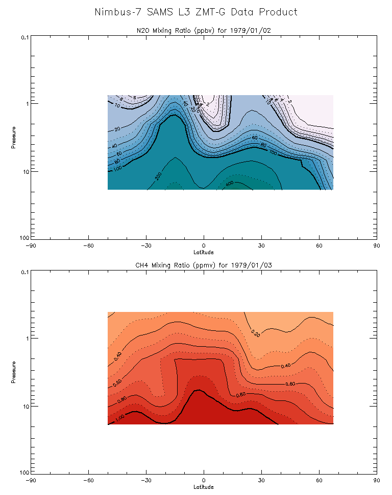
SAMS/Nimbus-7 Level 3 Zonal Means Composition Data V001 (SAMSN7L3ZMTG) at GES DISC
National Aeronautics and Space Administration —
SAMSN7L3ZMTG is the Nimbus-7 Stratospheric and Mesospheric Sounder (SAMS) Level 3 Zonal Means Composition Data Product. The Earth's surface is divided into 2.5-deg... -
Federal
TIROS-4 Medium-Resolution Scanning Radiometer Level 1 Final Meteorological Radiation Data V001 (TIROS4L1FMRT) at GES DISC
National Aeronautics and Space Administration —
TIROS-4 Medium-Resolution Scanning Radiometer Level 1 Final Meteorological Radiation Data (FMRT) product contains radiances expressed in five infrared/visible... -
Federal
TIROS-3 Medium-Resolution Scanning Radiometer Level 1 Final Meteorological Radiation Data V001 (TIROS3L1FMRT) at GES DISC
National Aeronautics and Space Administration —
TIROS-3 Medium-Resolution Scanning Radiometer Level 1 Final Meteorological Radiation Data (FMRT) product contains radiances expressed in five infrared/visible... -
Federal
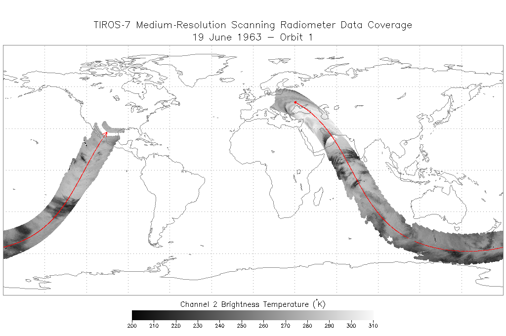
TIROS-7 Medium-Resolution Scanning Radiometer Level 1 Final Meteorological Radiation Data V001 (TIROS7L1FMRT) at GES DISC
National Aeronautics and Space Administration —
TIROS-7 Medium-Resolution Scanning Radiometer Level 1 Final Meteorological Radiation Data (FMRT) product contains radiances expressed in five infrared/visible... -
Federal
ACTIVATE FLEXible PARTicle (FLEXPART) Dispersion Model Back-trajectories
National Aeronautics and Space Administration —
ACTIVATE-FLEXPART is the FLEXible PARTicle dispersion model back-trajectories ending at the HU-25 Falcon locations. ACTIVATE was a 5-year NASA Earth-Venture Sub-...
2,273 datasets found for "BG真人和AG真人的区别✅澳门葡京赌场官方网站-网址【079.one】㊙️最火爆PG电子超高爆奖率,注册即送38元.ljkidVptaiG"