
-
Federal
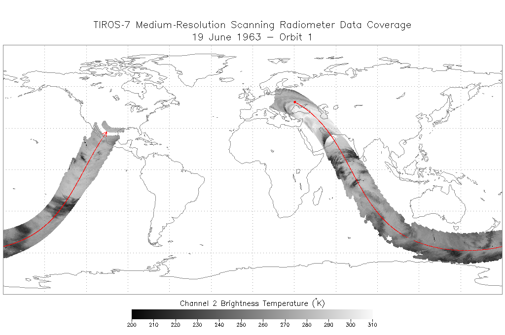
TIROS-7 Medium-Resolution Scanning Radiometer Level 1 Final Meteorological Radiation Data V001 (TIROS7L1FMRT) at GES DISC
National Aeronautics and Space Administration —
TIROS-7 Medium-Resolution Scanning Radiometer Level 1 Final Meteorological Radiation Data (FMRT) product contains radiances expressed in five infrared/visible... -
Federal
TEMPO geolocated Earth radiances V03 (PROVISIONAL)
National Aeronautics and Space Administration —
Level 1 radiance files provide radiance information at TEMPO’s native spatial resolution, ~10 km^2 at the center of the Field of Regard (FOR), for individual... -
Federal
TEMPO dark exposure V03 (PROVISIONAL)
National Aeronautics and Space Administration —
Level 1 dark files provide the processed dark currents, corresponding to either solar irradiance measurements or radiance measurements. Each file includes the... -
Federal
Pre-Delta-X: Spectral Reflectance of Water Surface, Atchafalaya Basin, LA, USA, 2016
National Aeronautics and Space Administration —
This dataset provides measurements of in situ remote-sensing reflectance (Rrs; per steradian) of surface water across Atchafalaya Basin, southern coastal Louisiana,... -
Federal
Optical Thickness Data: Bruegge (FIFE)
National Aeronautics and Space Administration —
The NIPS and Reagan Sunphotometer Optical Thickness study compared various ground and image-based techniques used to characterize the atmosphere. These data are used... -
Federal
Optical Thickness Data: C-130 (FIFE)
National Aeronautics and Space Administration —
The data in the Sunphotometer Optical Thickness Data from C130 Aircraft data set were collected in June, July and August 1987, and in August 1989. The data was... -
Federal
PhenoCam Dataset v2.0: Digital Camera Imagery from the PhenoCam Network, 2000-2018
National Aeronautics and Space Administration —
This dataset provides a time series of visible-wavelength digital camera imagery collected through the PhenoCam Network at each of 393 sites predominantly in North... -
Federal
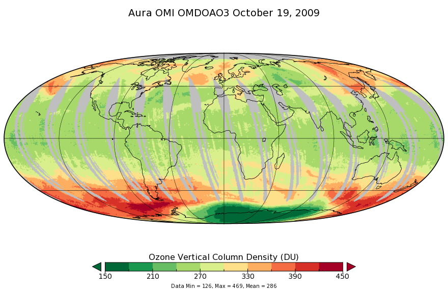
OMI/Aura Ozone (O3) DOAS Total Column Daily L3 1 day 0.25 degree x 0.25 degree V3 (OMDOAO3e) at GES DISC
National Aeronautics and Space Administration —
The OMI science team produces this Level-3 Aura/OMI Global OMDOAO3e Data Products (0.25deg Lat/Lon grids). This Level-3 global total column ozone product is derived... -
Federal
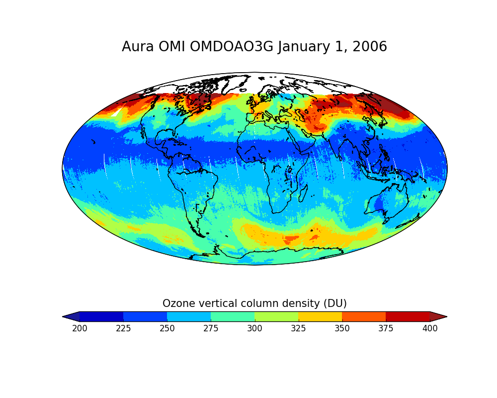
OMI/Aura Ozone (O3) DOAS Total Column Daily L2 Global Gridded 0.25 degree x 0.25 degree V3 (OMDOAO3G) at GES DISC
National Aeronautics and Space Administration —
This Level-2G daily global gridded product OMDOAO3G is based on the pixel level OMI Level-2 DOAO3 product OMDOAO3. This Level-2G global total column ozone product is... -
Federal
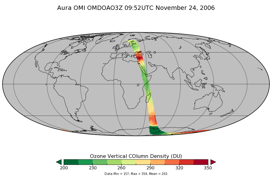
OMI/Aura DOAS Total Column Ozone Zoomed 1-Orbit L2 Swath 13x12km V003 (OMDOAO3Z) at GES DISC
National Aeronautics and Space Administration —
The reprocessed Aura Ozone Monitoring Instrument (OMI) Level-2 Zoomed Ozone data product OMDOAO3Z at 13x12 km resolution is now available from the NASA Goddard Earth... -
Federal
Pre-Delta-X: AVIRIS-derived Total Suspended Solids Maps for MRD, LA, USA, 2015-2016
National Aeronautics and Space Administration —
This dataset includes total suspended solids (TSS) at the water surface across the Atchafalaya and Terrebonne Basins in Southern Louisiana, USA, within the... -
Federal
OMI/Aura Level 1B VIS Zoom-in Geolocated Earthshine Radiances 1-orbit L2 Swath 13x12 km V003 (OML1BRVZ) at GES DISC
National Aeronautics and Space Administration —
The Aura Ozone Monitoring Instrument (OMI) Level-1B (L1B) Geo-located Earth View VIS Radiance, Zoom-in-Mode (OML1BRVZ) Version-3 product contains geo-located Earth... -
Federal
OMI/Aura Level 1B VIS Zoom-in Geolocated Earthshine Radiances V004 (OML1BRVZ) at GES DISC
National Aeronautics and Space Administration —
The Aura Ozone Monitoring Instrument (OMI) Level 1B (L1B) Zoom-in Earthshine UV Radiance, Zoom-mode (shortname OML1BRVZ) Version 4 product contains geolocated Earth... -
Federal
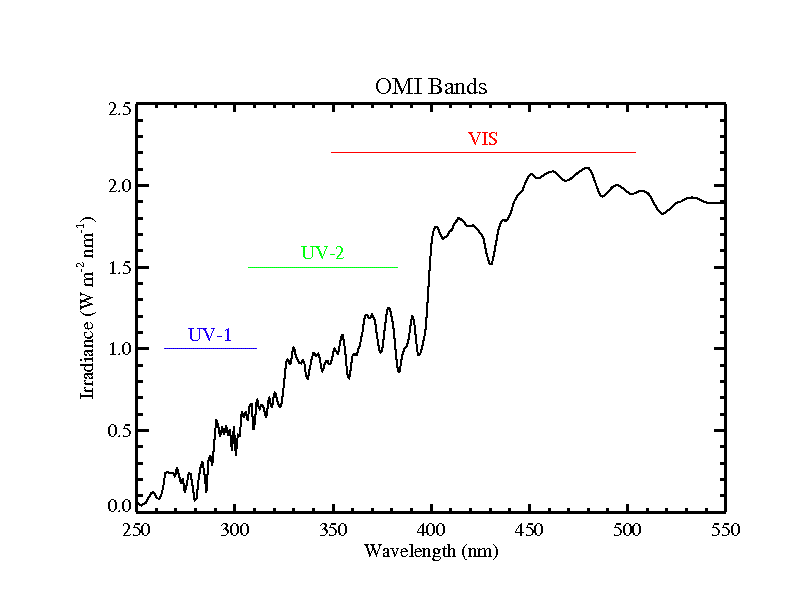
OMI/Aura Level 1B Solar Irradiances V003 (OML1BIRR) at GES DISC
National Aeronautics and Space Administration —
The OMI Level 1B solar irradiance product is the radiometrically calibrated and geolocated measurements of the UV and Visible channels of the spectral solar... -
Federal
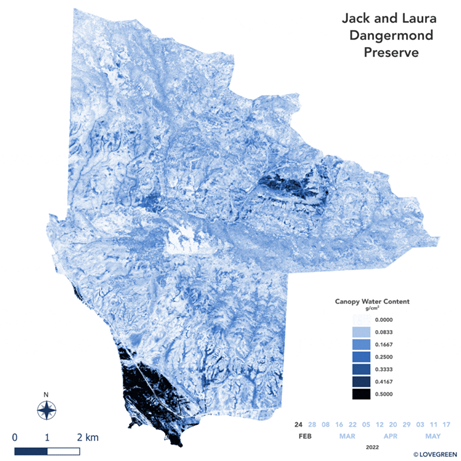
SHIFT: AVIRIS-NG Derived Gridded Mosaicked Canopy Water Content, California, 2022
National Aeronautics and Space Administration —
This dataset provides per-pixel vegetation canopy water content (CWC) derived from surface reflectance measured by the Airborne Visible/Infrared Imaging Spectrometer-... -
Federal
Gemma Helicopter Data (FIFE)
National Aeronautics and Space Administration —
During the 1989 Intensive Field Campaign a Russian spectroradiometer, the Gemma, was used to collect visible and near infrared spectra of a variety of FIFE sites from... -
Federal
EMIT L1B At-Sensor Calibrated Radiance and Geolocation Data 60 m V001
National Aeronautics and Space Administration —
The Earth Surface Mineral Dust Source Investigation (EMIT) instrument measures surface mineralogy, targeting the Earth’s arid dust source regions. EMIT is installed... -
Federal
FLASHFlux Daily Gridded TOA and Surfaces/Clouds data Version 4B
National Aeronautics and Space Administration —
FLASH_TISA_Terra-NOAA20_Version4B is the Fast Longwave And SHortwave Fluxes (FLASHFlux) Daily Gridded Top-of-Atmosphere (TOA) and Surfaces/Clouds Version 4B data... -
Federal
GPM TMI on TRMM unpacked data L1A 1.5 hours 13 km V07 (GPM_1ATMI) at GES DISC
National Aeronautics and Space Administration —
This is the new (GPM-formated) TRMM product. It replaces the old TRMM_1A11 Version 07 is the current version of the data set. Previous versions have been superseded...

Official websites use .gov
A
.gov website belongs to an official government
organization in the United States.
Secure .gov websites use HTTPS
A
lock (
) or https:// means you’ve safely connected to
the .gov website. Share sensitive information only on official,
secure websites.