
-
Federal
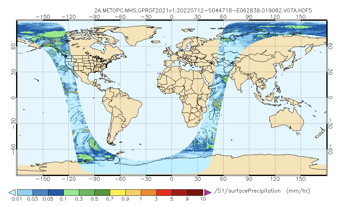
GPM MHS on METOP-C (GPROF) Radiometer Precipitation Profiling L2A 1.5 hours 17 km V07 (GPM_2AGPROFMETOPCMHS) at GES DISC
National Aeronautics and Space Administration —
Version 07 is the current version of the data set. The 2AGPROF (also known as, GPM GPROF (Level 2)) algorithm retrieves consistent precipitation and related science... -
Federal
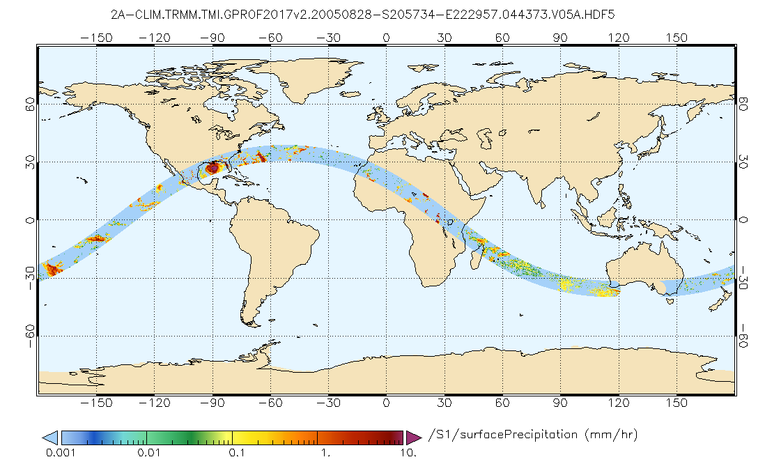
GPM TMI on TRMM (GPROF) Climate-based Radiometer Precipitation Profiling L2A 1.5 hours 13 km V07 (GPM_2AGPROFTRMMTMI_CLIM) at GES DISC
National Aeronautics and Space Administration —
This is the new (GPM-formated) TRMM product. It replaces the old TRMM_2A12 Version 07 is the current version of the data set. Older versions will no longer be... -
Federal
GPM AMSR-E on Aqua (GPROF) Climate-based Radiometer Precipitation Profiling L2 1.5 hours 5 km V07 (GPM_2AGPROFAQUAAMSRE_CLIM) at GES DISC
National Aeronautics and Space Administration —
Version 07 is the current version of the data set. Older versions will no longer be available and have been superseded by Version 07. The 'CLIM' products differ from... -
Federal
PEM Tropics B DC-8 Remotely Sensed Data
National Aeronautics and Space Administration —
PEM-Tropics-B_AircraftRemoteSensing_DC8_Data is the remote sensing data collected onboard the DC-8 aircraft during the Pacific Exploratory Mission (PEM) Tropics B... -
Federal
LBA-ECO ND-01 Streamwater and Watershed Characteristics, Rondonia, Brazil: 1998-1999
National Aeronautics and Space Administration —
This data set provides the results of (1) synoptic streamwater sampling and analyses from numerous sites across Rondonia and (2) corresponding watershed... -
Federal
GPM SSMIS on F18 (GPROF) Climate-based Radiometer Precipitation Profiling 1.5 hours 12 km V07 (GPM_2AGPROFF18SSMIS_CLIM) at GES DISC
National Aeronautics and Space Administration —
Version 07 is the current version of the data set. Older versions will no longer be available and have been superseded by Version 07. The 'CLIM' products differ from... -
Federal
GPM MHS on METOP-A (GPROF) Radiometer Precipitation Profiling L2A 1.5 hours 17 km V07 (GPM_2AGPROFMETOPAMHS_CLIM) at GES DISC
National Aeronautics and Space Administration —
Version 07 is the current version of the data set. Older versions are no longer available and have been superseded by Version 07.The "CLIM" products differ from their... -
Federal
SAFARI 2000 C-130 Aerosol and Meteorological Data, Dry Season 2000
National Aeronautics and Space Administration —
The Met Office C-130 research aircraft was based at Windhoek, Namibia between September 5-16, 2000, where it conducted a series of flights over Namibia as part of the... -
Federal
Global Food Security-support Analysis Data (GFSAD) Cropland Extent 2015 Europe, Central Asia, Russia, Middle East product 30 m V001
National Aeronautics and Space Administration —
The NASA Making Earth System Data Records for Use in Research Environments (MEaSUREs) Global Food Security-support Analysis Data (GFSAD) data product provides... -
Federal
VEMAP 1: U.S. Climate Change Scenarios Based on Models with Increased CO2
National Aeronautics and Space Administration —
The Vegetation/Ecosystem Modeling and Analysis Project (VEMAP) is an ongoing multiinstitutional, international effort addressing the response of biogeography and... -
Federal
NARSTO Pacific 2001 Air Quality Study (PAC2001) Slocan Park (SLPK) Slocan Park Site Gaseous, Partculate Matter (PM), and Meteorological Data
National Aeronautics and Space Administration —
NARSTO_PAC2001_SLOCAN_PARK_GAS_PM_MET_DATA is the North American Research Strategy for Tropospheric Ozone (NARSTO) Pacific 2001 Air Quality Study (PAC2001) Slocan... -
Federal
PEM Tropics A DC-8 In-Situ Trace Gas Data
National Aeronautics and Space Administration —
PEM-Tropics-A_TraceGas_AircraftInSitu_DC8_Data is the in-situ trace gas data collected onboard the DC-8 aircraft during the Pacific Exploratory Mission (PEM) Tropics... -
Federal
LBA-ECO LC-01 Hydrography, Morphology, Edaphology Maps, Northern Ecuadorian Amazon
National Aeronautics and Space Administration —
This data set provides map images of hydrographic, morphologic, and edaphic features for the northern Amazon Basin in eastern Ecuador. The hydrographic data are... -
Federal
CLAMS Chesapeake Lighthouse Vaisala RS-80 Radiosonde
National Aeronautics and Space Administration —
CLAMS_CERES_CHESLIGHT_SONDE data were collected during the Chesapeake Lighthouse and Aircraft Measurements for Satellites (CLAMS) experiment.The... -
Federal
ASTER L2 Surface Radiance VNIR and Crosstalk Corrected SWIR V004
National Aeronautics and Space Administration —
The Terra Advanced Spaceborne Thermal Emission and Reflection Radiometer (ASTER) Surface Radiance VNIR and Crosstalk Corrected SWIR (AST_09XT) contains... -
Federal
PEM Tropics A P-3B In-Situ Trace Gas Data
National Aeronautics and Space Administration —
PEM-Tropics-A_TraceGas_AircraftInSitu_P3B_Data is the in-situ trace gas data collected onboard the P-3B aircraft during the Pacific Exploratory Mission (PEM) Tropics... -
Federal
EMIT L2A Estimated Surface Reflectance and Uncertainty and Masks 60 m V001
National Aeronautics and Space Administration —
The Earth Surface Mineral Dust Source Investigation (EMIT) instrument measures surface mineralogy, targeting the Earth’s arid dust source regions. EMIT is installed... -
Federal
AMAZE-08 Aerosol Characterization and Meteorological Data, Central Amazon Basin: 2008
National Aeronautics and Space Administration —
This data set provides measurements from the Amazonian Aerosol Characterization Experiment (AMAZE-08) carried out during the wet season from February 4 to March 21,... -
Federal
NACP MsTMIP: Global and North American Driver Data for Multi-Model Intercomparison
National Aeronautics and Space Administration —
This data set provides environmental data that have been standardized and aggregated for use as input to carbon cycle models at global (0.5-degree resolution) and...

Official websites use .gov
A
.gov website belongs to an official government
organization in the United States.
Secure .gov websites use HTTPS
A
lock (
) or https:// means you’ve safely connected to
the .gov website. Share sensitive information only on official,
secure websites.