

216 datasets found for "FARS"
-
Federal
LMOS Grafton Ground Site Data
National Aeronautics and Space Administration —
LMOS_Ground_Grafton_Data_1 is the Lake Michigan Ozone Study (LMOS) Grafton ground site data collected during the LMOS field campaign. This product is a result of a... -
Federal
LMOS Sheboygan Ground Site Data
National Aeronautics and Space Administration —
LMOS_Ground_Sheboygan_Data_1 is the Lake Michigan Ozone Study (LMOS) is Sheboygan ground site data collected during the LMOS field campaign. This product is a result... -
Federal
LMOS Schiller Park Ground Site Data
National Aeronautics and Space Administration —
LMOS_Ground_SchillerPark_Data_1 is the Lake Michigan Ozone Study (LMOS) data collected at the Schiller Park ground site during the LMOS field campaign. This product... -
Federal
LBA-ECO CD-04 Meteorological and Flux Data, km 83 Tower Site, Tapajos National Forest
National Aeronautics and Space Administration —
We used two independent approaches, biometry and micrometeorology, to determine the net ecosystem production (NEP) of an old growth forest in Para, Brazil. Biometric... -
Federal
LBA-ECO ND-02 Trace Gas Flux from Forest Soil, Para, Brazil : 1999-2001
National Aeronautics and Space Administration —
Understanding secondary successional processes in Amazonian terrestrial ecosystems is becoming increasingly important as continued deforestation expands the area that... -
Federal
NCEP/CPC L3 Half Hourly 4km Global (60S - 60N) Merged IR V1 (GPM_MERGIR) at GES DISC
National Aeronautics and Space Administration —
These data originate from NOAA/NCEP.The NOAA Climate Prediction Center/NCEP/NWS is making the data available originally in binary format, in a weekly rotating... -
Federal
Polar Radiant Energy in the Far InfraRed Experiment (PREFIRE) Cloud Properties from PREFIRE Satellite 1 R01
National Aeronautics and Space Administration —
Polar Radiant Energy in the Far InfraRed Experiment (PREFIRE) Satellite 1 Cloud Properties (PREFIRE_SAT1_2B-CLD) contains cloud properties derived from data collected... -
Federal
Polar Radiant Energy in the Far InfraRed Experiment (PREFIRE) Spectral Flux from PREFIRE Satellite 2 R01
National Aeronautics and Space Administration —
Polar Radiant Energy in the Far InfraRed Experiment (PREFIRE) Spectral Flux from PREFIRE Satellite 2 (PREFIRE_SAT2_2B-FLX) contains surface emissivity derived from... -
Federal
RANS Simulation VBM of Single Full Scale DOE RM1 MHK Turbine
Department of Energy —
Attached are the .cas and .dat files along with the required User Defined Functions (UDFs) and look-up table of lift and drag coefficients for Reynolds Averaged... -
Federal
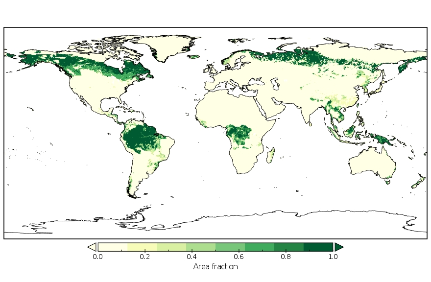
LUH2-GCB2019: Land-Use Harmonization 2 Update for the Global Carbon Budget, 850-2019
National Aeronautics and Space Administration —
This dataset, referred to as LUH2-GCB2019, includes 0.25-degree gridded, global maps of fractional land-use states, transitions, and management practices for the... -
Federal
Polar Radiant Energy in the Far InfraRed Experiment (PREFIRE) Surface Emissivity Sorted All-sky Climatology from PREFIRE Satellite 1 R01
National Aeronautics and Space Administration —
Polar Radiant Energy in the Far InfraRed Experiment (PREFIRE) Surface Emissivity Sorted All-sky Climatology from PREFIRE Satellite 1 (PREFIRE_SAT1_3-SFC-... -
Federal
TOLNet NASA Jet Propulsion Laboratory Data
National Aeronautics and Space Administration —
TOLNet_JPL_Data are lidar data collected by several ozone Differential Absorption Lidar instruments developed at the NASA Jet Propulsion Laboratory Table Mountain... -
Federal
Polar Radiant Energy in the Far InfraRed Experiment (PREFIRE) Surface Emissivity from PREFIRE Satellite 2 COG11um R01
National Aeronautics and Space Administration —
Polar Radiant Energy in the Far InfraRed Experiment (PREFIRE) Surface Emissivity from PREFIRE Satellite 2 COG11um (PREFIRE_SAT2_2B-SFC_COG11um) is derived from data... -
Federal
NPP Grassland: Consistent Worldwide Site Estimates, 1954-1990, R1
National Aeronautics and Space Administration —
The NPP Database contains documented field measurements of NPP for global terrestrial sites compiled from published literature and other extant data sources. The NPP... -
Federal
Imagery data for the Vegetation Mapping Inventory Project of Saguaro National Park
Department of the Interior —
This reference contains the imagery data used in the completion of the baseline vegetation inventory project for the NPS park unit. Orthophotos, raw imagery, and... -
Federal
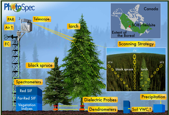
Tower-based PhotoSpec Products for the 2019 and 2020 Spring Transition Season, SK, CA
National Aeronautics and Space Administration —
This dataset includes daily averaged solar-induced chlorophyll fluorescence (SIF) in the red (680-686 nm) and far-red (745-758 nm) wavelength ranges, relative SIF...
216 datasets found for "FARS"