

306,686 datasets found
-
Federal
2006 American Community Survey: 1-Year Estimates - Public Use Microdata Sample recent views
Department of Commerce —
The American Community Survey (ACS) Public Use Microdata Sample (PUMS) contains a sample of responses to the ACS. The ACS PUMS dataset includes variables for nearly... -
Federal
OASDI Beneficiaries by State and ZIP Code - 2017 recent views
Social Security Administration —
This annual publication focuses on the Social Security beneficiary population at the ZIP code level. It presents basic program data on the number and type of... -
Federal
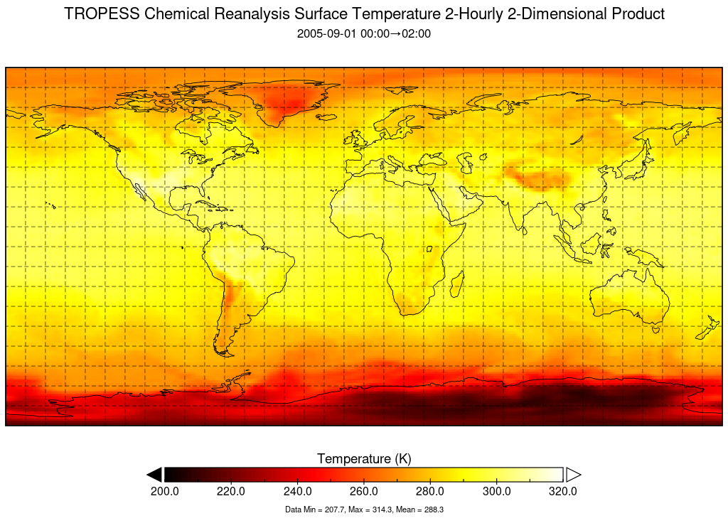
TROPESS Chemical Reanalysis Surface Temperature 2-Hourly 2-dimensional Product V1 (TRPSCRT2H2D) at GES DISC recent views
National Aeronautics and Space Administration —
The TROPESS Chemical Reanalysis Surface Temperature 2-Hourly 2-dimensional Product contains surface temperature values, a meteorological field. The data are part of... -
Federal
TIGER/Line Shapefile, 2023, County, Terrell County, TX, All Lines recent views
U.S. Census Bureau, Department of Commerce —
The TIGER/Line shapefiles and related database files (.dbf) are an extract of selected geographic and cartographic information from the U.S. Census Bureau's Master... -
Federal
OASDI Beneficiaries by State and County - 2009 recent views
Social Security Administration —
This annual publication focuses on the Social Security beneficiary population receiving Old-Age, Survivors, and Disability Insurance (OASDI) benefits at the local... -
Truck and Bus Through Route recent views
District of Columbia —
For the purposes of the map, a Truck is defined as a vehicle with a gross vehicle weight rating greater than 26,000 pounds with a carrying capacity of more than 1 and... -
Federal
2023 Cartographic Boundary File (SHP), Census Tract for Florida, 1:500,000 recent views
U.S. Census Bureau, Department of Commerce —
The 2023 cartographic boundary shapefiles are simplified representations of selected geographic areas from the U.S. Census Bureau's Master Address File /... -
Federal
OASDI Beneficiaries by State and County - 2004 recent views
Social Security Administration —
This annual publication focuses on the Social Security beneficiary population receiving Old-Age, Survivors, and Disability Insurance (OASDI) benefits at the local... -
City
Blockface space inventory recent views
City of Seattle —
The Parking Blockface data are an inventory of paid parking blocks with the number of paid spaces within city limits. A blockface is a side of a Seattle street. The... -
Federal
Mississippi School Food Service Directors' Interest in and Experience with Farm to School recent views
Department of Agriculture —
The dataset contains information collected from 122 K-12 public school food service directors in Mississippi, USA, who completed an online survey designed for... -
State
NAIP 2012 4-Band 1m California recent views
State of California —
This service delivers all 4 bands of the NAIP 2012 1-meter resolution aerial imagery. This service may be slower than other related NAIP 2012 services because of the... -
Federal
Do Not Call (DNC) Reported Calls Data 6/8/18 - 6/14/18 recent views
Federal Trade Commission —
This data set includes information on Do Not Call and robocall complaints reported to the Federal Trade Commission. The data set contains information reported by... -
Federal
Data for initial journal submission Figures 1-4 Tables 1-3_Jan2021 recent views
U.S. Environmental Protection Agency —
The Figure files contain GIS files used to derive the maps of Michigan. The Tables files are .dbf files that provide values reflecting changes over time and... -
Federal
1-meter swath bathymetric grid collected by the U.S. Geological Survey in Moultonborough Bay, Lake Winnipesaukee, New Hampshire in 2005 (UTM Zone 19N, WGS 84, Esri Binary Grid, WINNI_BATHY) recent views
Department of the Interior —
In freshwater bodies of New Hampshire, the most problematic aquatic invasive plant species is Myriophyllum heterophyllum or variable leaf water-milfoil. Once... -
Federal
NREL GIS data: Bhutan Wind Power Density at 50m Above Ground Level recent views
Department of Energy —
GIS data for Bhutan's Wind Power Density at 50m Above Ground Level. NREL developed estimates of Bhutans wind resources at a spatial resolution of 1 km^2 using NREL?s... -
Federal
OASDI Beneficiaries by State and County - 2010 recent views
Social Security Administration —
This annual publication focuses on the Social Security beneficiary population receiving Old-Age, Survivors, and Disability Insurance (OASDI) benefits at the local... -
State
MD iMAP: Maryland Sport Venues - Lacrosse recent views
State of Maryland —
This is a MD iMAP hosted service layer. Find more information at http://imap.maryland.gov. Maryland Sports (http://www.marylandsports.us/) has identified sport venues... -
Federal
Distributed Anomaly Detection using 1-class SVM for Vertically Partitioned Data recent views
National Aeronautics and Space Administration —
There has been a tremendous increase in the volume of sensor data collected over the last decade for different monitoring tasks. For example, petabytes of earth... -
Federal
TIGER/Line Shapefile, Current, County, Sierra County, CA, All Roads recent views
U.S. Census Bureau, Department of Commerce —
This resource is a member of a series. The TIGER/Line shapefiles and related database files (.dbf) are an extract of selected geographic and cartographic information...
306,686 datasets found