
-
Federal
JPSS-1 CrIS Level 1B Principal Component Analysis / Rapid Event Detection V3.0 (SNDRJ1CrISL1BPCARED) at GES DISC
National Aeronautics and Space Administration —
This sample data collection contains L1B radiance values that are compressed and denoised via Principal Component Analysis (PCA). Additionally it contains a new Rapid... -
Federal
Global Seasonal-Snow Classification, Version 1
National Aeronautics and Space Administration —
This data set consists of global, seasonal snow classifications—e.g., tundra, boreal forest, maritime, ephemeral, prairie, montane forest, and ice—determined from air... -
Federal
2014 Lake Erie measurements
National Aeronautics and Space Administration —
2014 Lake Erie measurements. -
Federal
TOVS GLA DAILY GRIDS from NOAA-9 V01 (TOVSADNF) at GES DISC
National Aeronautics and Space Administration —
This dataset (TOVSADNF) contains the TIROS Operational Vertical Sounder (TOVS) level 3 geophysical parameters derived using data from NOAA-9 and the physical... -
Federal
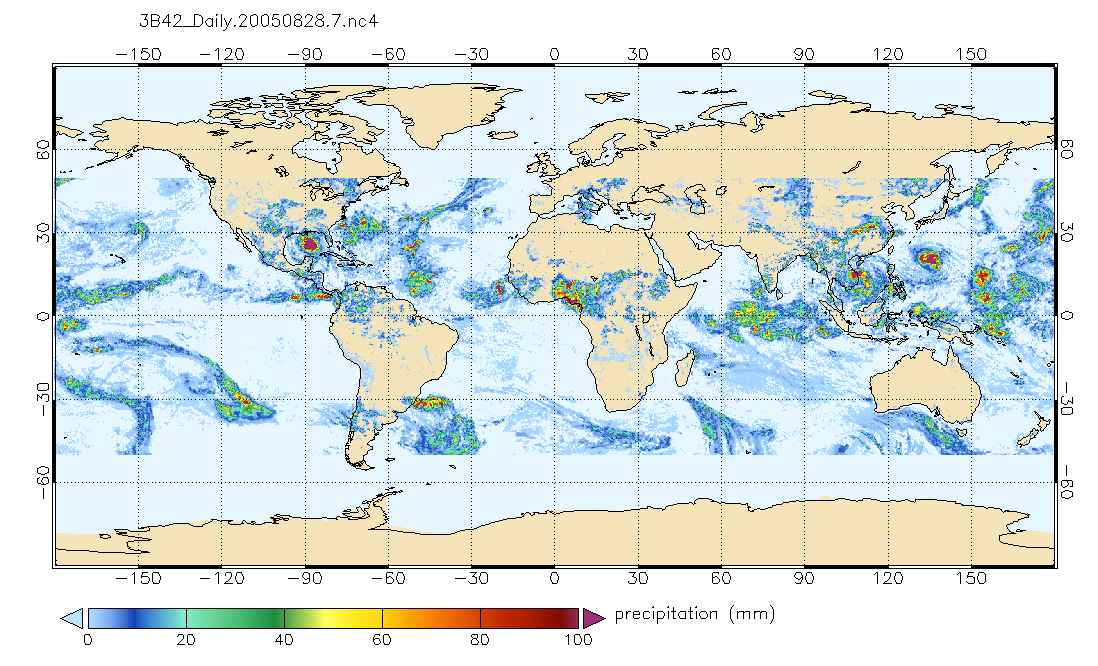
TRMM (TMPA) Precipitation L3 1 day 0.25 degree x 0.25 degree V7 (TRMM_3B42_Daily) at GES DISC
National Aeronautics and Space Administration —
TMPA (3B42_Daily) dataset have been discontinued as of Dec. 31, 2019, and users are strongly encouraged to shift to the successor IMERG dataset (doi:... -
Federal
TOVS GLA 5 DAY GRIDS from NOAA-9 V01 (TOVSA5NF) at GES DISC
National Aeronautics and Space Administration —
This dataset (TOVSA5NF) contains the TIROS Operational Vertical Sounder (TOVS) level 3 geophysical parameters derived using data from NOAA-9 and the physical... -
Federal
Terra MODIS Level-3 Global Binned 11µm Day/Night Sea Surface Temperature (SST) - Near Real-time (NRT) Data, version R2019.0
National Aeronautics and Space Administration —
The Ocean Biology DAAC produces near real-time (quicklook) products using the best-available combination of ancillary data from meteorological and ozone data. As... -
Federal
MuSLI Multi-Source Land Surface Phenology Yearly North America 30 m V011
National Aeronautics and Space Administration —
The Multi-Source Land Surface Phenology (LSP) Yearly North America 30 meter (m) Version 1.1 product (MSLSP) provides a Land Surface Phenology product for North... -
Federal
AIRS/Aqua L3 Daily Standard Physical Retrieval (AIRS-only) 1 degree x 1 degree V006 (AIRS3STD) at GES DISC
National Aeronautics and Space Administration —
The Atmospheric Infrared Sounder (AIRS) is a grating spectrometer (R = 1200) aboard the second Earth Observing System (EOS) polar-orbiting platform, EOS Aqua. In... -
Federal
OCO-2 Level 2 geolocated XCO2 retrievals results, physical model V11.2 (OCO2_L2_Standard) at GES DISC
National Aeronautics and Space Administration —
Version 11.2 is the current version of the data set. Older versions will no longer be available and are superseded by Version 11.2. The Orbiting Carbon Observatory is... -
Federal
SENTINEL-1A_DUAL_POL_METADATA_GRD_MEDIUM_RES
National Aeronautics and Space Administration —
Sentinel-1A Dual-pol ground projected medium resolution metadata -
Federal
Nimbus-7 Narrow Field of View (NFOV) Maximum Likelihood Cloud Estimation (MLCE) Data in Native Format
National Aeronautics and Space Administration —
NIMBUS7_NFOV_MLCE data are Nimbus 7 Narrow Field of View (NFOV) Maximum Likelihood Cloud Estimation (MLCE) Data in Native Format.The NIMBUS7_NFOV_MLCE data set uses... -
Federal
MODIS/Aqua Geolocation Fields 1km 5-Min 1A Narrow Swath Subset along CloudSat V002 (MAC03S0) at GES DISC
National Aeronautics and Space Administration —
This is the narrow-swath MODIS/Aqua subset along CloudSat field of view track. The goal of the narrow-swath subset is to select and return MODIS data that are within... -
Federal
ALOS PALSAR Level 1.0 Product
National Aeronautics and Space Administration —
ALOS PALSAR Level 1.0 -
Federal
MODIS/Terra Net Primary Production Gap-Filled Yearly L4 Global 500m SIN Grid V061
National Aeronautics and Space Administration —
The MOD17A3HGF Version 6.1 product provides information about annual Gross and Net Primary Production (GPP and NPP) at 500 meter (m) pixel resolution. Annual Terra... -
Federal
STS-59_METADATA_GRD
National Aeronautics and Space Administration —
Metadata for STS-59 SIR-C Ground Range Product -
Federal
Global Forest Ecosystem Structure and Function Data For Carbon Balance Research
National Aeronautics and Space Administration —
A comprehensive global database has been assembled to quantify CO2 fluxes and pathways across different levels of integration (from photosynthesis up to net ecosystem... -
Federal
TRMM Ground Validation Calibrated QC Radar Reflectivity Full Volume Scan L1C 1 hour V7 (TRMM_1C51) at GES DISC
National Aeronautics and Space Administration —
The purpose of the 1C51 algorithm is to remove non-meteorological radar echoes that adversely affect the quality of higher level products, such as clutter associated... -
Federal
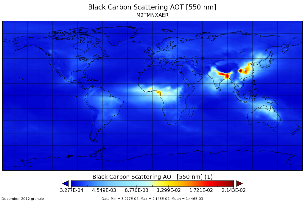
MERRA-2 tavgM_2d_aer_Nx: 2d,Monthly mean,Time-averaged,Single-Level,Assimilation,Aerosol Diagnostics 0.625 x 0.5 degree V5.12.4 (M2TMNXAER) at GES DISC
National Aeronautics and Space Administration —
M2TMNXAER (or tavgM_2d_aer_Nx) is a time-averaged 2-dimensional monthly mean data collection in Modern-Era Retrospective analysis for Research and Applications... -
Federal
International Ice Patrol Annual North Atlantic Iceberg Summaries and Reports, Version 1
National Aeronautics and Space Administration —
The International Ice Patrol (IIP) has been monitoring iceberg activity in the North Atlantic since 1913. This data set contains yearly summaries and reports of these...

Official websites use .gov
A
.gov website belongs to an official government
organization in the United States.
Secure .gov websites use HTTPS
A
lock (
) or https:// means you’ve safely connected to
the .gov website. Share sensitive information only on official,
secure websites.