
-
Federal
Hawaii Play Fairway Analysis: USGS 2007 Geologic Map of the State of Hawaii
Department of Energy —
Geologic Map of the State of Hawaii published by the USGS in 2007. Includes downloadable GIS layers. Used in the Play Fairway project to obtain location of calderas,... -
Federal
Sentinel-3A OLCI Regional Mapped Inland Waters (ILW) Data, version 4
National Aeronautics and Space Administration —
The Inland Waters dataset (ILW) provides data for lakes and other water bodies across the contiguous United States (CONUS) and Alaska. ILW significantly reduces the... -
Federal
Assessment of the infectious diseases surveillance system of the Republic of Armenia: an example of surveillance in the Republics of the former Soviet Union
U.S. Department of Health & Human Services —
Background Before 1991, the infectious diseases surveillance systems (IDSS) of the former Soviet Union (FSU) were centrally planned in Moscow. The dissolution of the... -
Federal
Behavioral Health Barometer: South Dakota, Volume 4
U.S. Department of Health & Human Services —
Behavioral Health Barometer: South Dakota, Volume 4 -
Federal
The role of neuraminidase inhibitors in the treatment and prevention of influenza
U.S. Department of Health & Human Services —
The role of neuraminidase inhibitors in the treatment and prevention of influenza -
Federal
Assisted Reproductive Technology (ART) Surveillance
U.S. Department of Health & Human Services —
In 1992, Congress enacted the Fertility Clinic Success Rate and Certification Act (FCSRCA). The act requires CDC to collect data from clinics and submit an annual... -
Federal
2011-2012 NSDUH: Other Sources of State-level Data
U.S. Department of Health & Human Services —
A variety of surveys and data systems other than the National Survey on Drug Use and Health (NSDUH) collect data on substance use and mental health problems. It is... -
Federal
Veto Violence - Violence Education Tools Online
U.S. Department of Health & Human Services —
VetoViolence.cdc.gov has been developed by the Centers for Disease Control and Prevention (CDC) to provide grantees and partners with access to training and tools... -
Federal
School District Characteristics 2018-19
Department of Education —
The National Center for Education Statistics’ (NCES) Education Demographic and Geographic Estimate (EDGE) program develops annually updated school district boundary... -
Federal
POLARIS Balloonsondes and Ozonesondes Data
National Aeronautics and Space Administration —
POLARIS_MetNav_AircraftInSitu_ER2_Data is the balloonsonde and ozonesonde data collected during the Photochemistry of Ozone Loss in the Arctic Region in Summer... -
Federal
Sounder SIPS: AQUA AIRS IR + MW Level 2: Atmospheric state at Standard Pressure Levels derived from CLIMCAPS V2.1 (SNDRAQIML2PLEVCPS) at GES DISC
National Aeronautics and Space Administration —
The CLIMCAPS (Community Long-term Infrared Microwave Coupled Product System) algorithm is used to analyze data from the AIRS (Atmospheric Infrared Sounder)/AMSU... -
Federal
CYGNSS Level 2 Ocean Surface Heat Flux Science Data Record Version 2.0
National Aeronautics and Space Administration —
This dataset contains the Version 2.0 CYGNSS Level 2 Ocean Surface Heat Flux Science Data Record, which provides time-tagged and geolocated ocean surface heat flux... -
Federal
DISCOVER-AQ Colorado Deployment Mobile Platform Data
National Aeronautics and Space Administration —
DISCOVERAQ_Colorado_Ground_Mobile_Data contains data collected via the Princeton Mobile Lab and NASA Langley LARGE Mobile Lab during the Colorado (Denver) deployment... -
Federal
BOREAS HYD-08 1996 Gross Precipitation Data
National Aeronautics and Space Administration —
The BOREAS HYD-08 team made measurements of surface hydrological processes at the SSA-OBS Tower Flux site to support its research into point hydrological processes... -
Federal
TRMM (TMPA-RT) Near Real-Time Precipitation L3 3 hour 0.25 degree x 0.25 degree V7 (TRMM_3B42RT) at GES DISC
National Aeronautics and Space Administration —
TMPA (3B42RT) dataset have been discontinued as of Dec. 31, 2019, and users are strongly encouraged to shift to the successor IMERG datasets (doi:... -
Federal
GRACE-FO Level-1B Release version 4.0 from JPL in ASCII
National Aeronautics and Space Administration —
FOR EXPERT USE ONLY. The GRACE-FO Level-1B data provide all necessary inputs to derive monthly time variations in the Earth gravity field. Level-1B data are also used... -
Federal
GPM MHS on METOP-B (GPROF) Radiometer Precipitation Profiling L3 1 day 0.25 degree x 0.25 degree V07 (GPM_3GPROFMETOPBMHS_DAY) at GES DISC
National Aeronautics and Space Administration —
Version 07 is the current version of the data set. Older versions will no longer be available and have been superseded by Version 07. 3GPROF products provide global... -
Federal
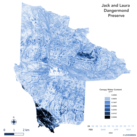
SHIFT: AVIRIS-NG Derived Gridded Mosaicked Canopy Water Content, California, 2022
National Aeronautics and Space Administration —
This dataset provides per-pixel vegetation canopy water content (CWC) derived from surface reflectance measured by the Airborne Visible/Infrared Imaging Spectrometer-... -
Federal
First ISCCP Regional Experiment (FIRE) Cirrus Phase II University of North Dakota Citation Aircraft 1 Hertz Data
National Aeronautics and Space Administration —
The First ISCCP Regional Experiments have been designed to improve data products and cloud/radiation parameterizations used in general circulation models (GCMs).... -
University
New Mexico, 2010 Census Combined Statistical Area (CSA) State-based
Earth Data Analysis Center, University of New Mexico —
The TIGER/Line Files are shapefiles and related database files (.dbf) that are an extract of selected geographic and cartographic information from the U.S. Census...

Official websites use .gov
A
.gov website belongs to an official government
organization in the United States.
Secure .gov websites use HTTPS
A
lock (
) or https:// means you’ve safely connected to
the .gov website. Share sensitive information only on official,
secure websites.