
-
State
Alaska landslide inventory database
State of Alaska —
Alaska landslide inventory database, Digital Data Series 23, provides a catalog of slope instabilities across Alaska and documents the development of the Alaska... -
Federal
Seascape Alaska 5: Gulf of Alaska ROV Exploration and Mapping
National Oceanic and Atmospheric Administration, Department of Commerce —
From August 23rd - September 14th, 2023 (Kodiak, Alaska to Seward, Alaska), NOAA Ocean Exploration conducted Seascape Alaska 5: Gulf of Alaska Remotely Operated... -
Federal
Blood Parasite Infection Data from Northwestern Crows (Corvus caurinus), Alaska, 2007-2008
Department of the Interior —
This data set consists of two tables associated with a study of Haemosporidian parasite infection in Northwestern Crows (Corvus caurinus) sampled at six locations... -
Federal
H05262A: NOS Hydrographic Survey
National Oceanic and Atmospheric Administration, Department of Commerce —
The National Oceanic and Atmospheric Administration (NOAA) has the statutory mandate to collect hydrographic data in support of nautical chart compilation for safe... -
Federal
Seward, Alaska 1/3 arc-second MHW Coastal Digital Elevation Model
National Oceanic and Atmospheric Administration, Department of Commerce —
The 1/3-second Seward Alaska Elevation Grid provides bathymetric data of 1/3-second resolution in geographic coordinates. This grid is strictly for tsunami inundation... -
Federal
TIGER/Line Shapefile, 2023, County, Seward County, NE, Linear Hydrography
U.S. Census Bureau, Department of Commerce —
The TIGER/Line shapefiles and related database files (.dbf) are an extract of selected geographic and cartographic information from the U.S. Census Bureau's Master... -
Federal
Seward, Alaska 3 arc-second MHW Coastal Digital Elevation Model
National Oceanic and Atmospheric Administration, Department of Commerce —
The 3 arc-second Seward Alaska Elevation Grid provides bathymetric data of 2.67-second resolution in geographic coordinates. This grid is strictly for tsunami... -
Federal
TIGER/Line Shapefile, 2024, County, Seward County, NE, Linear Hydrography
U.S. Census Bureau, Department of Commerce —
The TIGER/Line shapefiles and related database files (.dbf) are an extract of selected geographic and cartographic information from the U.S. Census Bureau's Master... -
Federal
Monthly and annual mean seawater temperature, salinity and density from 26 tide gauge sites during 1855-1993 (NCEI Accession 0000817)
National Oceanic and Atmospheric Administration, Department of Commerce —
Tidal observers at primary tide gauges of the United States Coast and Geodetic Survey (now the NOAA National Ocean Service) routinely measured seawater temperature... -
Federal
CTD and sound speed profile data acquired in support of hydrographic multibeam surveys to meet NOAA/NOS, Office of Coast Survey charting requirements
National Oceanic and Atmospheric Administration, Department of Commerce —
Multiple sensors are used to acquire sound speed profiles in the survey areas assigned to the ships and navigation response teams. Some vessels have CTDs and acquire... -
Federal
National Status and Trends: Mussel Watch Program - Resurrection Bay Database
National Oceanic and Atmospheric Administration, Department of Commerce —
In response to the growing concerns among Native communities about the safety of subsistence shellfish, this project assessed the health risks associated with... -
Federal
TIGER/Line Shapefile, 2022, County, Seward County, KS, Address Range-Feature Name Relationship File
U.S. Census Bureau, Department of Commerce —
The TIGER/Line shapefiles and related database files (.dbf) are an extract of selected geographic and cartographic information from the U.S. Census Bureau's Master... -
Federal
TIGER/Line Shapefile, Current, County, Seward County, NE, Topological Faces (Polygons With All Geocodes)
U.S. Census Bureau, Department of Commerce —
The TIGER/Line shapefiles and related database files (.dbf) are an extract of selected geographic and cartographic information from the U.S. Census Bureau's Master... -
Federal
H04678: NOS Hydrographic Survey
National Oceanic and Atmospheric Administration, Department of Commerce —
The National Oceanic and Atmospheric Administration (NOAA) has the statutory mandate to collect hydrographic data in support of nautical chart compilation for safe... -
Federal
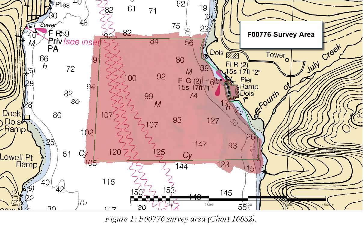
F00776: NOS Hydrographic Survey , 2019-06-05
National Oceanic and Atmospheric Administration, Department of Commerce —
The National Oceanic and Atmospheric Administration (NOAA) has the statutory mandate to collect hydrographic data in support of nautical chart compilation for safe... -
Federal
TIGER/Line Shapefile, Current, County, Seward County, NE, All Roads
U.S. Census Bureau, Department of Commerce —
This resource is a member of a series. The TIGER/Line shapefiles and related database files (.dbf) are an extract of selected geographic and cartographic information... -
Federal
TIGER/Line Shapefile, 2022, County, Seward County, KS, Topological Faces (Polygons With All Geocodes)
U.S. Census Bureau, Department of Commerce —
The TIGER/Line shapefiles and related database files (.dbf) are an extract of selected geographic and cartographic information from the U.S. Census Bureau's Master... -
Federal
TIGER/Line Shapefile, 2023, County, Seward County, KS, Topological Faces (Polygons With All Geocodes)
U.S. Census Bureau, Department of Commerce —
The TIGER/Line shapefiles and related database files (.dbf) are an extract of selected geographic and cartographic information from the U.S. Census Bureau's Master... -
Federal
Archival and Discovery of May 22, 1960 Tsunami Event on Marigrams
National Oceanic and Atmospheric Administration, Department of Commerce —
NOAA National Centers for Environmental Information have more than 3,000 tsunami marigram (tide gauge) records in both image and paper format. The majority of these... -
Federal
TIGER/Line Shapefile, 2024, County, Seward County, KS, Topological Faces-Area Hydrography Relationship File
U.S. Census Bureau, Department of Commerce —
The TIGER/Line shapefiles and related database files (.dbf) are an extract of selected geographic and cartographic information from the U.S. Census Bureau's Master...

Official websites use .gov
A
.gov website belongs to an official government
organization in the United States.
Secure .gov websites use HTTPS
A
lock (
) or https:// means you’ve safely connected to
the .gov website. Share sensitive information only on official,
secure websites.