
-
State
2019 California Water Quality Status Report
State of California —
The California Water Quality Status Report is an annual data-driven snapshot of the Water Board’s water quality and ecosystem data. This third edition of the report... -
Federal
Utah FORGE: Well 16A(78)-32 Drilling Data
Department of Energy —
This dataset includes survey data, drilling data, daily reports, summaries of daily operations, and rig photos from the drilling of Utah FORGE well 16A(78)-32, which... -
Federal
Digital Geologic-GIS Map of Everglades National Park and Vicinity, Florida (NPS, GRD, GRI, EVER, EVER digital map) adapted from Florida Geological Survey Open File Map Series maps by Green, Campbell, Scott, Means and Arthur (1995, 1996, 1997, 1998 and 1999), and Open-File Report map by Scott (2001), and U.S. Geological Survey Bulletin map by Bergendahl (1956), Open-File Report map by McCartan and Moy (1995), and Water-Resources maps by Causaras, Reese and Cunningham (1985, 1986 and 2000)
Department of the Interior —
The Digital Geologic-GIS Map of Everglades National Park and Vicinity, Florida is composed of GIS data layers and GIS tables, and is available in the following GRI-... -
State
Surface Water - Chemistry Results
State of California —
This data provides results from the California Environmental Data Exchange Network (CEDEN) for field and lab chemistry analyses. The data set contains two... -
Federal
Digital Geologic-GIS Map of Biscayne National Park and Vicinity, Florida (NPS, GRD, GRI, BISC, BISC digital map) adapted from Florida Geological Survey Open File Map Series maps by Green, Campbell and Scott (1995 and 1996) and Open-File Report map by Scott (2001), and U.S. Geological Survey Water-Resources Investigations Report maps by Causaras (1986) and Reese and Cunningham (2000)
Department of the Interior —
The Digital Geologic-GIS Map of Biscayne National Park and Vicinity, Florida is composed of GIS data layers and GIS tables, and is available in the following GRI-... -
Federal
Benthic Habitat Database
National Oceanic and Atmospheric Administration, Department of Commerce —
The NOAA Northeast Fisheries Science Center has, through the years, accumulated an extensive data base of qualitative and quantitative (wet weight and number per... -
Federal
Fluvial flooding and sea-level rise datasets related to benzo[a]pyrene transport at the Lower Darby Creek Area
U.S. Environmental Protection Agency —
Datasets include maps and excel spreadsheet data files used in modeling the combined impacts of fluvial flooding, mean higher high water tide, and sea level rise on... -
Federal
NorWeST Stream Temperatures 2040s (Feature Layer)
Department of Agriculture —
This layer represents modeled stream temperatures derived from the NorWeST point feature class (NorWest_TemperaturePoints). NorWeST summer stream temperature... -
Federal
EnviroAtlas - Average Annual Soil Loss (Scaled) - Existing Land Use / Land Cover Scenario for the Conterminous United States
U.S. Environmental Protection Agency —
This EnviroAtlas national dataset shows the average annual soil loss from each pixel in metric tons per hectare*10,000 for the conterminous United States for 2011... -
Federal
Dataset from Bunker Hill sediments microcosm study
U.S. Environmental Protection Agency —
A laboratory-based microcosm study was conducted from September 2023 to July 2024 by the Office of Research (ORD) Cincinnati Lab (ORD-CESER-LRTD-CAISB). QA Category B... -
Federal
H13636: NOS Hydrographic Survey , 2022-08-31
National Oceanic and Atmospheric Administration, Department of Commerce —
The National Oceanic and Atmospheric Administration (NOAA) has the statutory mandate to collect hydrographic data in support of nautical chart compilation for safe... -
Federal
NorWeST Observed Stream Temperature Points (Feature Layer)
Department of Agriculture —
This layer indicates the location of the observed stream temperature records used for the NorWeST database summaries. NorWeST summer stream temperature scenarios were... -
Federal
H13766: NOS Hydrographic Survey , 2023-12-10
National Oceanic and Atmospheric Administration, Department of Commerce —
The National Oceanic and Atmospheric Administration (NOAA) has the statutory mandate to collect hydrographic data in support of nautical chart compilation for safe... -
Federal
R-Factor for the Conterminous United States
National Oceanic and Atmospheric Administration, Department of Commerce —
The rainfall-runoff erosivity factor (R-Factor) quantifies the effects of raindrop impacts and reflects the amount and rate of runoff associated with the rain. The... -
Federal
H13474: NOS Hydrographic Survey , 2021-10-07
National Oceanic and Atmospheric Administration, Department of Commerce —
The National Oceanic and Atmospheric Administration (NOAA) has the statutory mandate to collect hydrographic data in support of nautical chart compilation for safe... -
State
References
State of Oregon —
SLIDO-4.5 is an Esri ArcGIS version 10.7 file geodatabase which can be downloaded here: https://www.oregon.gov/dogami/slido/Pages/data.aspx The geodatabase contains... -
Federal
NOAA/WDS Paleoclimatology - Sea surface temperature and Atlantic Meridional Overturning Circulation of the last 21,000 years
National Oceanic and Atmospheric Administration, Department of Commerce —
This archived Paleoclimatology Study is available from the NOAA National Centers for Environmental Information (NCEI), under the World Data Service (WDS) for... -
Federal
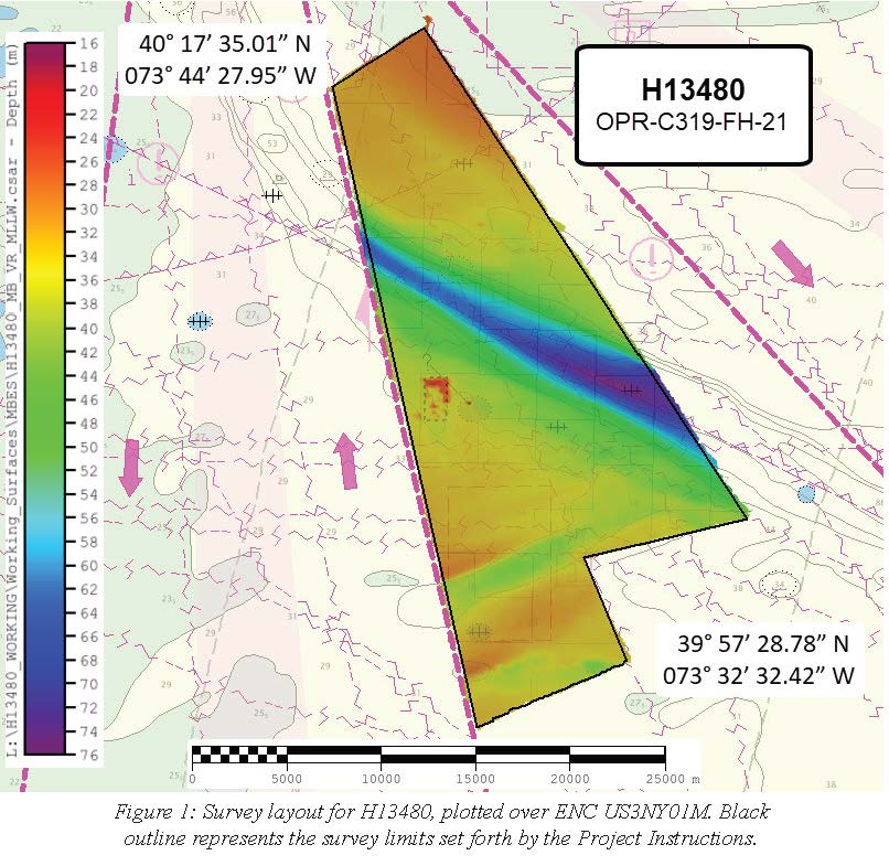
H13480: NOS Hydrographic Survey , 2021-10-07
National Oceanic and Atmospheric Administration, Department of Commerce —
The National Oceanic and Atmospheric Administration (NOAA) has the statutory mandate to collect hydrographic data in support of nautical chart compilation for safe... -
Federal
H13740: NOS Hydrographic Survey , 2023-08-17
National Oceanic and Atmospheric Administration, Department of Commerce —
The National Oceanic and Atmospheric Administration (NOAA) has the statutory mandate to collect hydrographic data in support of nautical chart compilation for safe... -
Federal
2004 Sediment Profile Imaging (SPI) Data for Catlett and Goodwin Islands on the York River, Chesapeake Bay, Virginia (Ches_2004SPI)
National Oceanic and Atmospheric Administration, Department of Commerce —
This data set represents the sediment profile imaging data from 2004 (79 stations).In Fall/Winter 2002, researchers from the Virginia Institute of Marine Science...

Official websites use .gov
A
.gov website belongs to an official government
organization in the United States.
Secure .gov websites use HTTPS
A
lock (
) or https:// means you’ve safely connected to
the .gov website. Share sensitive information only on official,
secure websites.