
-
Federal
UAV image and ground data of two citrus 'Valencia' orange (<i>Citrus</i> sinensis [L.] Osbeck) rootstock trials
Department of Agriculture —
The data are UAV (Unmanned Aerial Vehicle) and individual tree ground measurements collected from 2 citrus rootstock trials at the U.S. Horticultural Research... -
Federal
Global Hydrologic Soil Groups (HYSOGs250m) for Curve Number-Based Runoff Modeling
National Aeronautics and Space Administration —
This dataset - HYSOGs250m - represents a globally consistent, gridded dataset of hydrologic soil groups (HSGs) with a geographical resolution of 1/480 decimal... -
Federal
NACP North American Forest Dynamics Project: Forest Disturbance and Regrowth Data
National Aeronautics and Space Administration —
This data set provides the results of time-series analyses of Landsat imagery for 55 selected forested sites across the conterminous U.S.A. The output is a pair of... -
Federal
Ag and Food Statistics: Charting the Essentials
Department of Agriculture —
A collection of over 75 charts and maps presenting key statistics on the farm sector, food spending and prices, food security, rural communities, the interaction of... -
Federal
UAV image and ground data of citrus 'Bingo' mandarin hybrid (<i>Citrus </i>reticulata, Blanco) rootstock trial
Department of Agriculture —
The data are UAV ( (Unmanned Aerial Vehicle) and individual tree ground measurements collected in 2021 of 206 trees that were part of a citrus rootstock trial at the... -
Federal
Bowen Ratio Surface Flux: KSU (FIFE)
National Aeronautics and Space Administration —
The Bowen Ratio Surface Flux Observations (KSU) Data Set contains surface flux measurements made at selected sites within the FIFE area. The sites were equipped with... -
Federal
Data from: Validation of a real-time quaking-induced conversion (RT-QuIC) assay protocol to detect chronic wasting disease using rectal mucosa of naturally infected, pre-clinical white-tailed deer (<i>Odocoileus virginianus</i>)
Department of Agriculture —
Purpose of the study:The diagnostic performance of a standardized RT-QuIC protocol using two sources of assay substrate was studied for detecting chronic wasting... -
Federal
LUH1: Harmonized Global Land Use for Years 1500-2100, V1
National Aeronautics and Space Administration —
These data represent fractional land use and land cover patterns annually for the years 1500 - 2100 for the globe at 0.5-degree (~50-km) spatial resolution. Land use... -
Federal
Eddy Corr. Surface Flux: UK (FIFE)
National Aeronautics and Space Administration —
Surface flux measurements were made at selected sites within the FIFE study area. Each surface flux station was capable of measuring the fluxes of net radiation,... -
Federal
Net Radiation and Albedo from MODIS for Xingu River Basin, Brazil, 2000-2012
National Aeronautics and Space Administration —
This dataset provides daily average land surface net radiation (Rnet) as an 8-day time series at approximately 0.5 km resolution for the upper Xingu River Basin in... -
Federal
LBA-ECO LC-04 Satellite/Census-Based 5-Minute Land Use Data, Amazonia: 1980 and 1995
National Aeronautics and Space Administration —
Amazonia has been under considerable development pressure as croplands and pasture are established in areas formerly occupied by tropical forest and cerrado. Although... -
Federal
Forest Aboveground Biomass and Carbon Sequestration Potential for Maryland, USA.
National Aeronautics and Space Administration —
This dataset provides 90-m resolution maps of estimated forest aboveground biomass (Mg/ha) for nominal year 2011 and projections of carbon sequestration potential for... -
Federal
Global Distribution of Plant-Extractable Water Capacity of Soil (Dunne)
National Aeronautics and Space Administration —
Plant-extractable water capacity of soil is the amount of water that can be extracted from the soil to fulfill evapotranspiration demands. It is often assumed to be... -
Federal
LBA-ECO ND-02 Agricultural and Secondary Forest Soil Trace Gas Flux, Para: 2001-2004
National Aeronautics and Space Administration —
Fires set for slash-and-burn agriculture contribute to the current unsustainable accumulation of atmospheric greenhouse gases, and they also deplete the soil of... -
Federal
LiDAR Derived Biomass, Canopy Height, and Cover for New England Region, USA, 2015
National Aeronautics and Space Administration —
This dataset provides 30 m gridded estimates of aboveground biomass density (AGBD), forest canopy height, and tree canopy coverage for the New England Region of the... -
Federal
LBA-ECO TG-05 NPP, Carbon Pool, Soil Characteristics, Soil Gas Flux Maps of Brazil
National Aeronautics and Space Administration —
This data set provides maps produced from model output data from the National Aeronautics and Space Administration-Carnegie Ames Stanford Approach (NASA-CASA) model... -
Federal
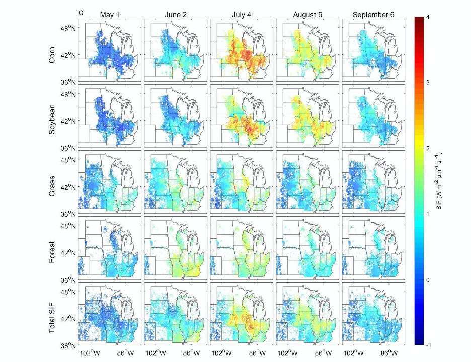
High Resolution Land Cover-Specific Solar-Induced Fluorescence, Midwestern USA, 2018
National Aeronautics and Space Administration —
This dataset provides estimated solar-induced chlorophyll fluorescence (SIF) of specific vegetation types and total SIF under clear-sky and real/cloudy conditions at... -
Federal
Eddy Corr. Surface Flux: USGS (FIFE)
National Aeronautics and Space Administration —
Surface flux measurements were made at selected sites within the FIFE area. Each surface flux station was capable of measuring the fluxes of net radiation, sensible... -
Federal
BOREAS TGB-07 Dry Deposition Herbicide and Organochlorine Flux Data
National Aeronautics and Space Administration —
The BOREAS TGB-07 team measured the concentration and flux of several agricultural pesticides in air, rainwater, and dry deposition samples in order to determine the...

Official websites use .gov
A
.gov website belongs to an official government
organization in the United States.
Secure .gov websites use HTTPS
A
lock (
) or https:// means you’ve safely connected to
the .gov website. Share sensitive information only on official,
secure websites.