
-
Federal
AIS data 66 recent views
National Oceanic and Atmospheric Administration, Department of Commerce —
Automatic identification system (AIS) data are used to identify and track vessels for various purposes (primarily navigational safety). These data can be used to... -
Federal
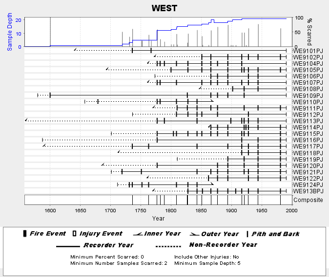
NOAA/WDS Paleoclimatology - Skinner fire data from WEST (San Pedro Martir) - IMPD MXWES001
National Oceanic and Atmospheric Administration, Department of Commerce —
This archived Paleoclimatology Study is available from the NOAA National Centers for Environmental Information (NCEI), under the World Data Service (WDS) for... -
Federal
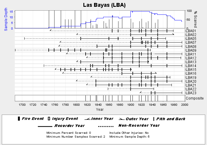
NOAA/WDS Paleoclimatology - Heyerdahl fire data from Las Bayas (LBA) - IMPD MXLBA001
National Oceanic and Atmospheric Administration, Department of Commerce —
This archived Paleoclimatology Study is available from the NOAA National Centers for Environmental Information (NCEI), under the World Data Service (WDS) for... -
Federal
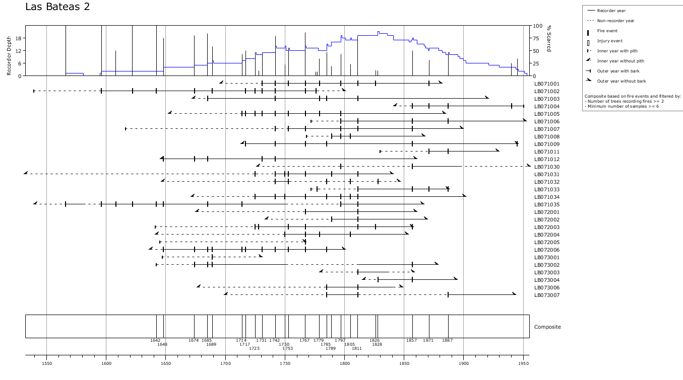
NOAA/WDS Paleoclimatology - Yocom fire data from Las Bateas 2, Sierra Madre Oriental, Coahuila, Mexico - IMPD MXLB-001
National Oceanic and Atmospheric Administration, Department of Commerce —
This archived Paleoclimatology Study is available from the NOAA National Centers for Environmental Information (NCEI), under the World Data Service (WDS) for... -
Federal
NOAA/WDS Paleoclimatology - Yocom fire data from Orizaba 4, eastern Transvolcanic Belt, Puebla, Mexico - IMPD MXOZ4001
National Oceanic and Atmospheric Administration, Department of Commerce —
This archived Paleoclimatology Study is available from the NOAA National Centers for Environmental Information (NCEI), under the World Data Service (WDS) for... -
Federal
NOAA/WDS Paleoclimatology - Yocom fire data from San Onofre, Sierra Madre Oriental, Nuevo León, Mexico - IMPD MXSO-001
National Oceanic and Atmospheric Administration, Department of Commerce —
This archived Paleoclimatology Study is available from the NOAA National Centers for Environmental Information (NCEI), under the World Data Service (WDS) for... -
Federal
Port Ensenada, Mexico Digital Elevation Model - 3 arc-second
National Oceanic and Atmospheric Administration, Department of Commerce —
Digital Elevation Model for Port Ensenada, Baja California, Mexico -
Federal
NCEP North American Regional Reanalysis (NARR), for 1979 to Present
National Oceanic and Atmospheric Administration, Department of Commerce —
The North America Regional Reanalysis (NARR) Project is a reanalysis of historical observations using a 32-km version of the National Centers for Environmental... -
Federal
Hurricane Katrina Poster (August 28, 2005)
National Oceanic and Atmospheric Administration, Department of Commerce —
Hurricane Katrina poster. Multi-spectral image from NOAA-18 shows a very large Hurricane Katrina as a category 5 hurricane in the Gulf of Mexico on August 28, 2005.... -
Federal
NOAA/WDS Paleoclimatology - Yocom fire data from Orizaba 1, eastern Transvolcanic Belt, Puebla, Mexico - IMPD MXOZ1001
National Oceanic and Atmospheric Administration, Department of Commerce —
This archived Paleoclimatology Study is available from the NOAA National Centers for Environmental Information (NCEI), under the World Data Service (WDS) for... -
Federal
NOAA/WDS Paleoclimatology - Heyerdahl fire data from El Carpintero (CAR) - IMPD MXCAR001
National Oceanic and Atmospheric Administration, Department of Commerce —
This archived Paleoclimatology Study is available from the NOAA National Centers for Environmental Information (NCEI), under the World Data Service (WDS) for... -
Federal
NOAA/WDS Paleoclimatology - Yocom fire data from Orizaba 3, eastern Transvolcanic Belt, Puebla, Mexico - IMPD MXOZ3001
National Oceanic and Atmospheric Administration, Department of Commerce —
This archived Paleoclimatology Study is available from the NOAA National Centers for Environmental Information (NCEI), under the World Data Service (WDS) for... -
Federal
NOAA/WDS Paleoclimatology - Yocom fire data from Orizaba 6, eastern Transvolcanic Belt, Puebla, Mexico - IMPD MXOZ6001
National Oceanic and Atmospheric Administration, Department of Commerce —
This archived Paleoclimatology Study is available from the NOAA National Centers for Environmental Information (NCEI), under the World Data Service (WDS) for... -
Federal
NOAA/WDS Paleoclimatology - Yocom fire data from ParaÃso, Sierra Madre Oriental, Coahuila, Mexico - IMPD MXPA-001
National Oceanic and Atmospheric Administration, Department of Commerce —
This archived Paleoclimatology Study is available from the NOAA National Centers for Environmental Information (NCEI), under the World Data Service (WDS) for... -
Federal
Geoid Height and Deflections of the Vertical Models - National Geospatial Data Asset (NGDA) Geoid Models NGDA
National Oceanic and Atmospheric Administration, Department of Commerce —
In Gauss' words, the geoid is "the mathematical figure of the Earth". This figure is an equipotential surface coincident with the idealized mean sea surface. The... -
Federal
The Olympia & Pacific Oyster Data Portal
National Oceanic and Atmospheric Administration, Department of Commerce —
Locations (i.e., "records") of Ostrea lurida (Olympia oysters) and Magallana gigas (Pacific oysters) observed 1602 to 2020 along the west coast of North America.... -
Federal
Surface ocean velocities obtained by HF radar from stations located along coastal waters of Hawaii, North Slope Alaska, Puerto Rico/Virgin Islands, eastern US/Gulf of Mexico and western US
National Oceanic and Atmospheric Administration, Department of Commerce —
The National Data Buoy Center in collaboration with the Scripps Institution of Oceanography assembles the data from the Integrated Ocean Observing System Data... -
Federal
2005 Atlantic Hurricanes Poster
National Oceanic and Atmospheric Administration, Department of Commerce —
The 2005 Atlantic Hurricanes poster features high quality satellite images of 15 hurricanes which formed in the Atlantic Basin (includes Gulf of Mexico and Caribbean... -
Federal
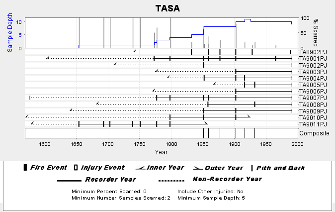
NOAA/WDS Paleoclimatology - Skinner fire data from TASA (San Pedro Martir) - IMPD MXTAS001
National Oceanic and Atmospheric Administration, Department of Commerce —
This archived Paleoclimatology Study is available from the NOAA National Centers for Environmental Information (NCEI), under the World Data Service (WDS) for... -
Federal
Annual survival of Yucatan nesting loggerheads
National Oceanic and Atmospheric Administration, Department of Commerce —
We deployed 30 Pop-off Archival Transmitting (PAT) satellite tags on nesting loggerhead turtles between 7 July and 11 July 2010 at Xel-Ha, XCacel, and Playa Aventuras...

Official websites use .gov
A
.gov website belongs to an official government
organization in the United States.
Secure .gov websites use HTTPS
A
lock (
) or https:// means you’ve safely connected to
the .gov website. Share sensitive information only on official,
secure websites.