
-
Federal
Landsat 8 23 recent views
National Aeronautics and Space Administration —
The Operational Land Imager (OLI) and Thermal Infrared Sensor (TIRS) are onboard the Landsat 8 satellite, have acquired images of the Earth since February 2013. The... -
Federal
SLSTR/Sentinel-3B L1 Full Resolution Top of Atmosphere Radiances and Brightness Temperature
National Aeronautics and Space Administration —
The SLSTR/Sentinel-3B L1 Full Resolution Top of Atmosphere Radiances and Brightness Temperature product with shortname S3B_SL_1_RBT, is generated from the data... -
Federal
CERES Bidirectional Scans JPSS-1 FM6 Edition1-CV
National Aeronautics and Space Administration —
CER_BDS_J01-FM6_Edition1-CV is the Clouds and the Earth's Radiant Energy System (CERES) Bidirectional Scans (BDS) Joint Polar Satellite System 1 (NOAA-20) Flight... -
Federal
CERES Bidirectional Scans Aqua FM3 Edition4
National Aeronautics and Space Administration —
CER_BDS_Aqua-FM3_Edition4 is the Clouds and the Earth's Radiant Energy System (CERES) Bidirectional Scans (BDS) Aqua Flight Model 3 (FM3) Edition 4 data product,... -
Federal
CERES Bidirectional Scans Aqua FM4 Edition4
National Aeronautics and Space Administration —
CER_BDS_Aqua-FM4_Edition4 is the Clouds and the Earth's Radiant Energy System (CERES) Bidirectional Scans (BDS) Aqua Flight Model 4 (FM4) Edition 4 data product,... -
Federal
CERES Bidirectional Scans Aqua FM4 Edition1-CV
National Aeronautics and Space Administration —
CER_BDS_Aqua-FM4_Edition1-CV is the Clouds and the Earth's Radiant Energy System (CERES) Bidirectional Scans (BDS) Aqua Flight Model 4 (FM4) Edition 1-CV data... -
Federal
CERES Bidirectional Scans Terra FM2 Edition1-CV
National Aeronautics and Space Administration —
CER_BDS_Terra-FM2_Edition1-CV is the Clouds and the Earth's Radiant Energy System (CERES) Bidirectional Scans (BDS) Terra Flight Model 2 (FM2) Edition1-CV data... -
Federal
VIIRS/JPSS1 Moderate Resolution Terrain Corrected Geolocation 6-Min L1 Swath 750m NRT
National Aeronautics and Space Administration —
The Near Real Time (NRT) VIIRS/JPSS1 Moderate Resolution Terrain Corrected Geolocation 6-Min L1 Swath 750m (VJ103MOD_NRT) product includes the geolocation fields that... -
Federal
TRMM Attitude and TMI Packets and Header Record L1A V7 (TRMM_1A11) at GES DISC
National Aeronautics and Space Administration —
The Level-1A Product file, "1A11", is a concatenation of Header record, Spacecraft Attitude packets, TMI Housekeeping packets, TMI Science Data packets, QACs and an... -
Federal
GPM VIRS on TRMM unpacked data L1A 1.5 hours 2 km V07 (GPM_1AVIRS) at GES DISC
National Aeronautics and Space Administration —
This is the new (GPM-formated) TRMM product. It replaces the old TRMM_1A01 Version 07 is the current version of the data set. Previous versions have been superseded... -
Federal
CERES Bidirectional Scans Aqua FM3 Edition1-CV
National Aeronautics and Space Administration —
CER_BDS_Aqua-FM3_Edition1-CV is the Clouds and the Earth's Radiant Energy System (CERES) Bidirectional Scans (BDS) Aqua Flight Model 3 (FM3) Edition1-CV data... -
Federal
CERES Bidirectional Scans NPP FM5 Edition1-CV
National Aeronautics and Space Administration —
CER_BDS_NPP-FM5_Edition1-CV is the Clouds and the Earth's Radiant Energy System (CERES) Bidirectional Scans (BDS) Suomi National Polar-orbiting Partnership (NPP)... -
Federal
CERES Bidirectional Scans Terra FM1 Edition1-CV
National Aeronautics and Space Administration —
CER_BDS_Terra-FM1_Edition1-CVis the Clouds and the Earth's Radiant Energy System (CERES) Bidirectional Scans (BDS) Terra Flight Model 1 (FM1) Edition1-CV data... -
Federal
Delta-X: AVIRIS-NG L1B Spectral Radiance Products, MRD, Louisiana, 2021
National Aeronautics and Space Administration —
This dataset provides Level 1B (L1B) radiance products from NASA's Airborne Visible Infrared Imaging Spectrometer- Next Generation (AVIRIS-NG) instrument acquired... -
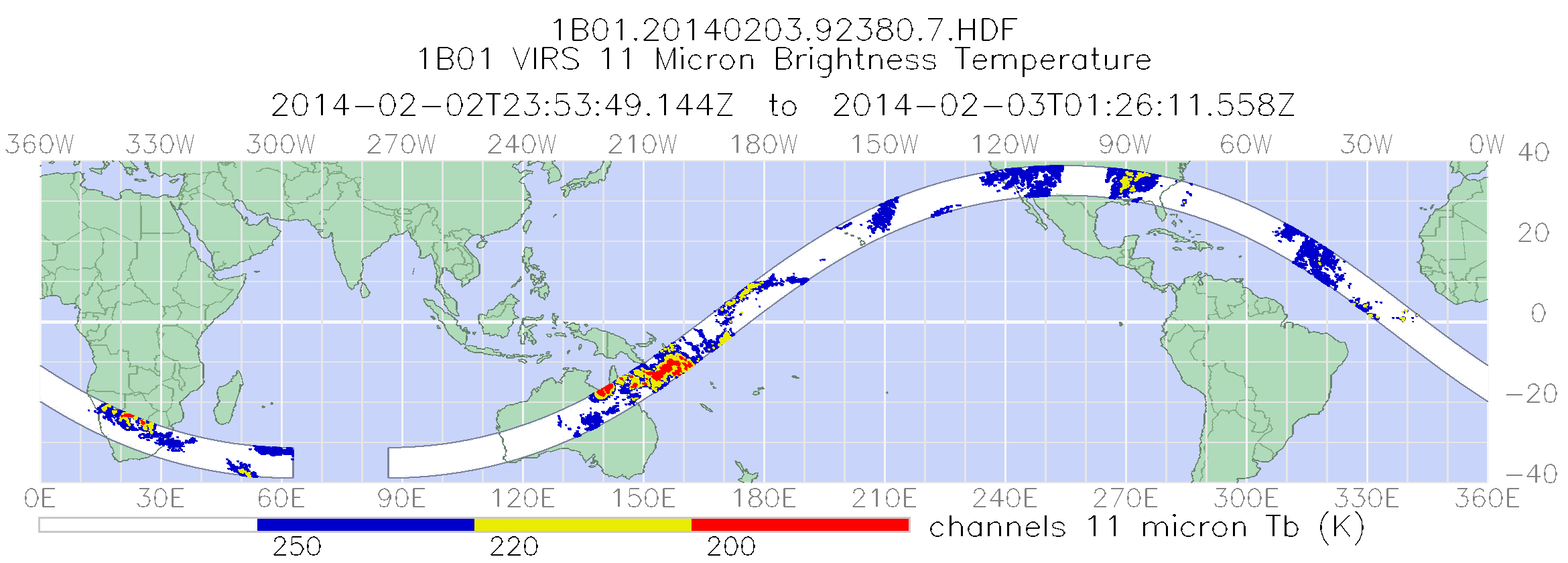
Federal
GPM VIRS on TRMM Radiance L1B 1.5 hours 2 km V07 (GPM_1BVIRS) at GES DISC
National Aeronautics and Space Administration —
This is the new (GPM-formated) TRMM product. It replaces the old TRMM_1B01 Version 07 is the current version of the data set. Previous versions have been superseded... -
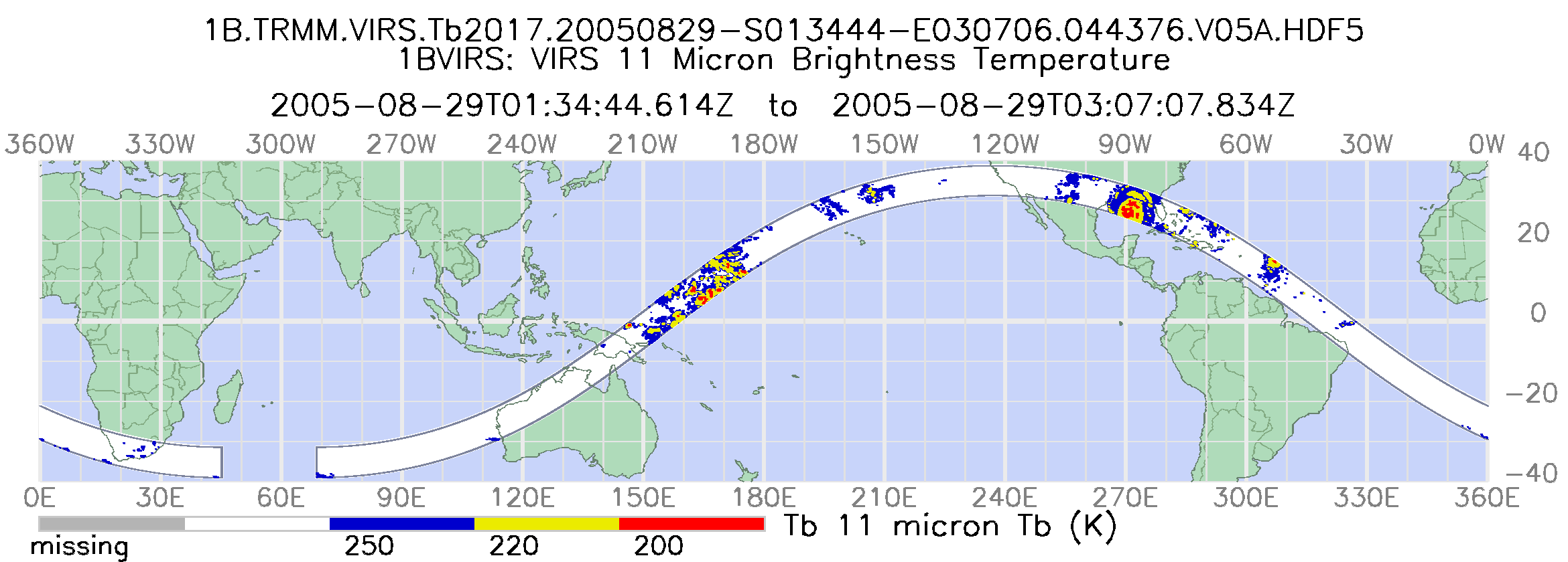
Federal
TRMM Visible and Infrared Scanner Calibrated Radiances L1B 1.5 hours V7 (TRMM_1B01) at GES DISC
National Aeronautics and Space Administration —
This TRMM Visible and Infrared Scanner (VIRS) Level 1B Calibrated Radiance Product (1B01) contains calibrated radiances and auxiliary geolocation information from the... -
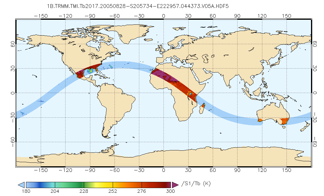
Federal
TRMM Microwave Imager Calibrated Radiances L1B 1.5 hours V7 (TRMM_1B11) at GES DISC
National Aeronautics and Space Administration —
This dataset contains TRMM Micrwave Imager (TMI) L1B calibrated radiances in terms of Brightness Temperatures. The TMI calibration algorithm (1B11) converts the... -
Federal
GPM TMI on TRMM Brightness Temperatures L1B 1.5 hours 13 km V07 (GPM_1BTMI) at GES DISC
National Aeronautics and Space Administration —
This is the new (GPM-formated) TRMM product. It replaces the old TRMM_1B11 Version 07 is the current version of the data set. Previous versions have been superseded... -
Federal
EMIT L2A Estimated Surface Reflectance and Uncertainty and Masks 60 m V001
National Aeronautics and Space Administration —
The Earth Surface Mineral Dust Source Investigation (EMIT) instrument measures surface mineralogy, targeting the Earth’s arid dust source regions. EMIT is installed... -
Federal
VIIRS/NPP Raw Radiances in Counts 6-Min L1A Swath NRT
National Aeronautics and Space Administration —
VIIRS/NPP Raw Radiances in Counts 6-Min L1A Swath - NRT product contains the unpacked, raw VIIRS science, calibration and engineering data; the extracted ephemeris...

Official websites use .gov
A
.gov website belongs to an official government
organization in the United States.
Secure .gov websites use HTTPS
A
lock (
) or https:// means you’ve safely connected to
the .gov website. Share sensitive information only on official,
secure websites.