
-
Federal
SCATSAT-1 ESDR Level 2 Modeled Ocean Surface Auxiliary Fields Version 1.0
National Aeronautics and Space Administration —
This dataset contains the first provisional release of the MEaSUREs-funded Earth Science Data Record (ESDR) of ancillary data corresponding to the SCATSAT-1 Level 2... -
Federal
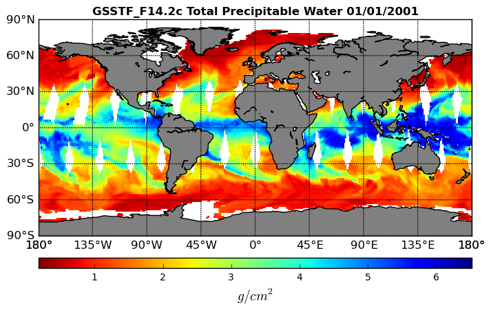
Goddard Satellite-Based Surface Turbulent Fluxes, 0.25 x 0.25 deg, Daily Grid F14 V3 (GSSTF_F14) at GES DISC
National Aeronautics and Space Administration —
These data are part of the Goddard Satellite-based Surface Turbulent Fluxes Version 3 (GSSTF3) Dataset recently produced through a MEaSURES funded project led by Dr.... -
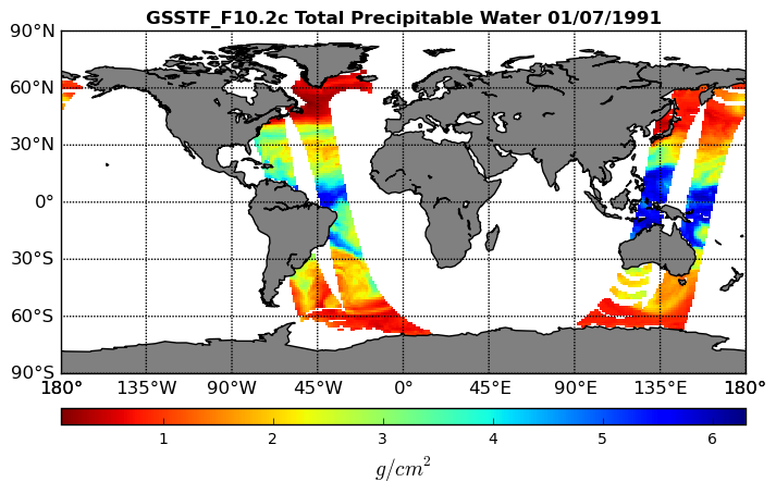
Federal
Goddard Satellite-Based Surface Turbulent Fluxes, 0.25 x 0.25 deg, Daily Grid F10 V3 (GSSTF_F10) at GES DISC
National Aeronautics and Space Administration —
These data are part of the Goddard Satellite-based Surface Turbulent Fluxes Version 3 (GSSTF3) Dataset recently produced through a MEaSURES funded project led by Dr.... -
Federal
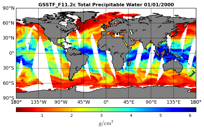
Goddard Satellite-Based Surface Turbulent Fluxes, 1x1 deg Daily Grid, Satellite F11 V2c (GSSTF_F11) at GES DISC
National Aeronautics and Space Administration —
These data are part of the Goddard Satellite-based Surface Turbulent Fluxes Version-2c (GSSTF 2c) Dataset recently produced through a MEaSURES funded project led by... -
Federal
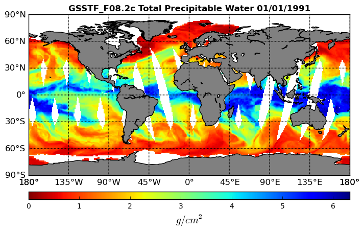
Goddard Satellite-Based Surface Turbulent Fluxes, 1x1 deg Daily Grid, Satellite F08 V2c (GSSTF_F08) at GES DISC
National Aeronautics and Space Administration —
These data are part of the Goddard Satellite-based Surface Turbulent Fluxes Version-2c (GSSTF 2c) Dataset recently produced through a MEaSURES funded project led by... -
Federal
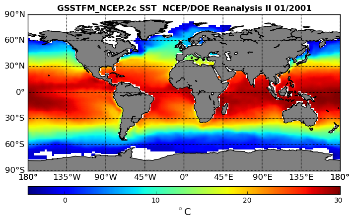
NCEP/DOE Reanalysis II in HDF-EOS5, for GSSTF2c, 1x1 deg Monthly grid V2c (GSSTFM_NCEP) at GES DISC
National Aeronautics and Space Administration —
These data are the Goddard Satellite-based Surface Turbulent Fluxes Version-2c Dataset recently produced through a MEaSURES funded project led by Dr. Chung-Lin Shie... -
Federal
Goddard Satellite-Based Surface Turbulent Fluxes Climatology, 0.25 x 0.25 deg, Yearly Grid V3 (GSSTFYC) at GES DISC
National Aeronautics and Space Administration —
These data are the Goddard Satellite-based Surface Turbulent Fluxes Version-3 Dataset recently produced through a MEaSUREs funded project led by Dr. Chung-Lin Shie... -
Federal
NCEP/DOE Reanalysis II, for GSSTF, 0.25x0.25 deg, Monthly grid V3 (GSSTFM_NCEP) at GES DISC
National Aeronautics and Space Administration —
These data are the Goddard Satellite-based Surface Turbulent Fluxes Version 3 Dataset recently produced through a MEaSURES funded project led by Dr. Chung-Lin Shie... -
Federal
TRMM MICROWAVE IMAGER (TMI) WENTZ OCEAN PRODUCTS V3
National Aeronautics and Space Administration —
The TRMM Microwave Imager (TMI) Wentz Ocean Products dataset used the TRMM Microwave Imager (TMI), which is a 5-channel, dual-polarized, passive microwave radiometer.... -
Federal
NCEP/DOE Reanalysis II, for GSSTF, 0.25 x 0.25 deg, Daily Grid V3 (GSSTF_NCEP) at GES DISC
National Aeronautics and Space Administration —
These data are the Goddard Satellite-based Surface Turbulent Fluxes Version 3 Dataset recently produced through a MEaSURES funded project led by Dr. Chung-Lin Shie... -
Federal
SASSIE Arctic Field Campaign Wave Glider Data Fall 2022 Version 1
National Aeronautics and Space Administration —
The Salinity and Stratification at the Sea Ice Edge (SASSIE) project is a NASA experiment that aims to understand how salinity anomalies in the upper ocean generated... -
Federal
Goddard Satellite-Based Surface Turbulent Fluxes, 0.25 x 0.25 deg, Daily Grid V3 (GSSTF) at GES DISC
National Aeronautics and Space Administration —
These data are the Goddard Satellite-based Surface Turbulent Fluxes Version-3 (GSSTF3) Dataset recently produced through a MEaSUREs funded project led by Dr. Chung-... -
Federal
Goddard Satellite-Based Surface Turbulent Fluxes, 1x1 deg Daily Grid, Satellite F13 V2c (GSSTF_F13) at GES DISC
National Aeronautics and Space Administration —
These data are part of the Goddard Satellite-based Surface Turbulent Fluxes Version-2c (GSSTF 2c) Dataset recently produced through a MEaSURES funded project led by... -
Federal
SASSIE Arctic Field Campaign L1 SWIFT Data Fall 2022
National Aeronautics and Space Administration —
The Salinity and Stratification at the Sea Ice Edge (SASSIE) project is a NASA experiment that aims to understand how salinity anomalies in the upper ocean generated... -
Federal
QuikSCAT ESDR Level 2 Modeled Ocean Surface Auxiliary Fields Version 1.0
National Aeronautics and Space Administration —
This dataset contains the first provisional release of the MEaSUREs-funded Earth Science Data Record (ESDR) of ancillary data corresponding to the QuikSCAT Level 2... -
Federal
MetOp-B ASCAT ESDR Level 2 Modeled Ocean Surface Auxiliary Fields Version 1.0
National Aeronautics and Space Administration —
This dataset contains the first provisional release of the MEaSUREs-funded Earth Science Data Record (ESDR) of ancillary data corresponding to the MetOp-B ASCAT... -
Federal
Summary Report of Community-Based Environmental and Species Observations from the Bering Sea Sub-Network, 2008-2009, Version 1
National Aeronautics and Space Administration —
The Bering Sea Sub-Network (BSSN) is comprised of a set of coastal communities representing six indigenous cultures: three in the Russian Federation and three in the... -
Federal
Goddard Satellite-Based Surface Turbulent Fluxes, 0.25 x 0.25 deg, Monthly Grid V3 (GSSTFM) at GES DISC
National Aeronautics and Space Administration —
These data are the Goddard Satellite-based Surface Turbulent Fluxes Version-3 Dataset recently produced through a MEaSUREs funded project led by Dr. Chung-Lin Shie... -
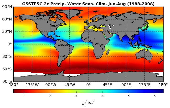
Federal
Goddard Satellite-Based Surface Turbulent Fluxes, 1x1 deg Seasonal Climatology, Set1 and NCEP V2c (GSSTFSC) at GES DISC
National Aeronautics and Space Administration —
These data are the Goddard Satellite-based Surface Turbulent Fluxes Version-2c Dataset recently produced through a MEaSUREs funded project led by Dr. Chung-Lin Shie... -
Federal
Goddard Satellite-Based Surface Turbulent Fluxes, 1x1 deg Daily Grid, Satellite F10 V2c (GSSTF_F10) at GES DISC
National Aeronautics and Space Administration —
These data are part of the Goddard Satellite-based Surface Turbulent Fluxes Version-2c (GSSTF 2c) Dataset recently produced through a MEaSURES funded project led by...

Official websites use .gov
A
.gov website belongs to an official government
organization in the United States.
Secure .gov websites use HTTPS
A
lock (
) or https:// means you’ve safely connected to
the .gov website. Share sensitive information only on official,
secure websites.