
-
Federal
Maritime Limits and Boundaries of United States of America NGDA 100 recent views
National Oceanic and Atmospheric Administration, Department of Commerce —
NOAA is responsible for depicting on its nautical charts the limits of the 12 nautical mile Territorial Sea, 24 nautical mile Contiguous Zone, and 200 nautical mile... -
Federal
Sea Level Trends: Sea Level Variations of the United States Derived from National Water Level Observation Network Stations NGDA 42 recent views
National Oceanic and Atmospheric Administration, Department of Commerce —
Water level records are a combination of the fluctuations of the ocean and the vertical land motion at the location of the station. Monthly mean sea level (MSL)... -
Federal
High Tide Flooding Products from NOAA CO-OPS
National Oceanic and Atmospheric Administration, Department of Commerce —
High tide flooding is the overflow or excess accumulation of water that covers typically dry coastal land and occurs during high tides. As relative sea levels rise,... -
Federal
Meteorological Data (including visibility)
National Oceanic and Atmospheric Administration, Department of Commerce —
The National Ocean Service (NOS) maintains a long-term database containing data from active and historic stations installed all over the United States and U.S.... -
Federal
Savannah River, GA/SC (S120) Bathymetric Digital Elevation Model (30 meter resolution) Derived From Source Hydrographic Survey Soundings Collected by NOAA
National Oceanic and Atmospheric Administration, Department of Commerce —
Bathymetry for the Savannah River was derived from nine surveys containing 34,353 soundings. Two older, overlapping, less accurate surveys were omitted before tinning... -
Federal
H00439: NOS Hydrographic Survey
National Oceanic and Atmospheric Administration, Department of Commerce —
The National Oceanic and Atmospheric Administration (NOAA) has the statutory mandate to collect hydrographic data in support of nautical chart compilation for safe... -
Federal
H12961: NOS Hydrographic Survey , Approaches to Savannah, 2017-09-14
National Oceanic and Atmospheric Administration, Department of Commerce —
The National Oceanic and Atmospheric Administration (NOAA) has the statutory mandate to collect hydrographic data in support of nautical chart compilation for safe... -
Federal
H00716: NOS Hydrographic Survey
National Oceanic and Atmospheric Administration, Department of Commerce —
The National Oceanic and Atmospheric Administration (NOAA) has the statutory mandate to collect hydrographic data in support of nautical chart compilation for safe... -
Federal
H00966: NOS Hydrographic Survey
National Oceanic and Atmospheric Administration, Department of Commerce —
The National Oceanic and Atmospheric Administration (NOAA) has the statutory mandate to collect hydrographic data in support of nautical chart compilation for safe... -
Federal
H00319: NOS Hydrographic Survey
National Oceanic and Atmospheric Administration, Department of Commerce —
The National Oceanic and Atmospheric Administration (NOAA) has the statutory mandate to collect hydrographic data in support of nautical chart compilation for safe... -
Federal
H00807: NOS Hydrographic Survey
National Oceanic and Atmospheric Administration, Department of Commerce —
The National Oceanic and Atmospheric Administration (NOAA) has the statutory mandate to collect hydrographic data in support of nautical chart compilation for safe... -
Federal
NOAA Water Levels for Coastal, Estuaries and Great Lakes regions
National Oceanic and Atmospheric Administration, Department of Commerce —
For over 200 years, NOAA's Center for Operational Oceanographic Products and Services (CO-OPS) and its predecessors have been managing a comprehensive system for... -
Federal
NOAA Composite Shoreline - Vectorized Shoreline Derived From NOAA-NOS Coastal Survey Maps and Aerial Photographs
National Oceanic and Atmospheric Administration, Department of Commerce —
The NOAA Composite Shoreline is primarily intended for high-resolution cartographic representation of the shoreline. It is a high-resolution vector shoreline based on... -
Federal
CO-OPS Air Gap Observations from Various Bridges within the United States and Its Territories
National Oceanic and Atmospheric Administration, Department of Commerce —
The Center for Operational Oceanographic Products and Services (CO-OPS) of the National Ocean Service (NOS), an organizational element of NOAA, operates and maintains... -
Federal
H00945: NOS Hydrographic Survey
National Oceanic and Atmospheric Administration, Department of Commerce —
The National Oceanic and Atmospheric Administration (NOAA) has the statutory mandate to collect hydrographic data in support of nautical chart compilation for safe... -
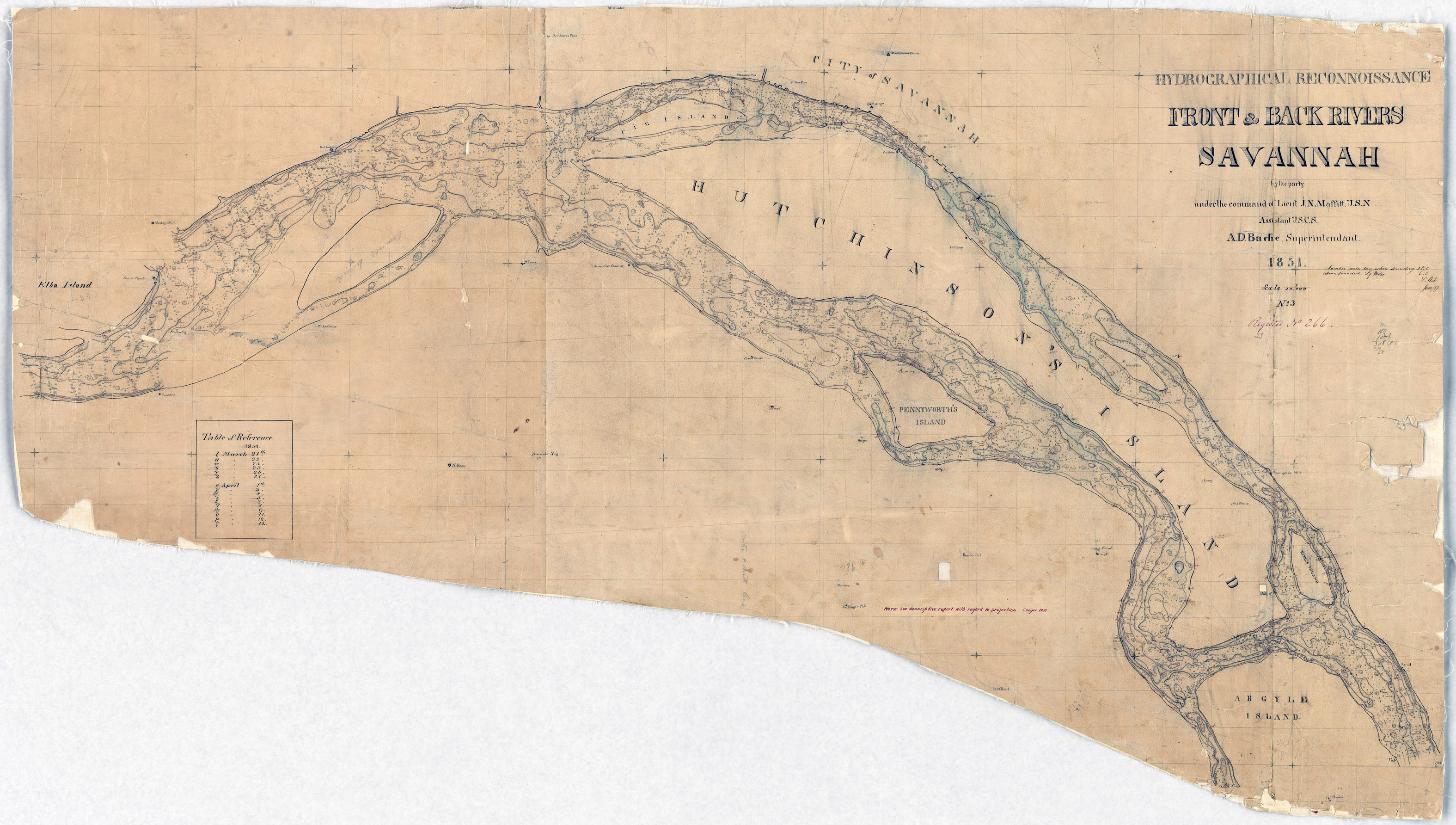
Federal
H00266: NOS Hydrographic Survey
National Oceanic and Atmospheric Administration, Department of Commerce —
The National Oceanic and Atmospheric Administration (NOAA) has the statutory mandate to collect hydrographic data in support of nautical chart compilation for safe... -
Federal
H03549: NOS Hydrographic Survey
National Oceanic and Atmospheric Administration, Department of Commerce —
The National Oceanic and Atmospheric Administration (NOAA) has the statutory mandate to collect hydrographic data in support of nautical chart compilation for safe... -
Federal
H00269: NOS Hydrographic Survey
National Oceanic and Atmospheric Administration, Department of Commerce —
The National Oceanic and Atmospheric Administration (NOAA) has the statutory mandate to collect hydrographic data in support of nautical chart compilation for safe... -
Federal
H09145: NOS Hydrographic Survey , Approaches to Port Royal Sound, South Carolina, 1973-10-02
National Oceanic and Atmospheric Administration, Department of Commerce —
The National Oceanic and Atmospheric Administration (NOAA) has the statutory mandate to collect hydrographic data in support of nautical chart compilation for safe... -
Federal
H00728: NOS Hydrographic Survey
National Oceanic and Atmospheric Administration, Department of Commerce —
The National Oceanic and Atmospheric Administration (NOAA) has the statutory mandate to collect hydrographic data in support of nautical chart compilation for safe...

Official websites use .gov
A
.gov website belongs to an official government
organization in the United States.
Secure .gov websites use HTTPS
A
lock (
) or https:// means you’ve safely connected to
the .gov website. Share sensitive information only on official,
secure websites.