
-
Federal
U.S. Hourly Precipitation Data recent views
National Oceanic and Atmospheric Administration, Department of Commerce —
Hourly Precipitation Data (HPD) is digital data set DSI-3240, archived at the National Climatic Data Center (NCDC). The primary source of data for this file is... -
Federal
Maritime Limits and Boundaries of United States of America NGDA recent views
National Oceanic and Atmospheric Administration, Department of Commerce —
NOAA is responsible for depicting on its nautical charts the limits of the 12 nautical mile Territorial Sea, 24 nautical mile Contiguous Zone, and 200 nautical mile... -
Federal
Sea Level Trends: Sea Level Variations of the United States Derived from National Water Level Observation Network Stations NGDA recent views
National Oceanic and Atmospheric Administration, Department of Commerce —
Water level records are a combination of the fluctuations of the ocean and the vertical land motion at the location of the station. Monthly mean sea level (MSL)... -
Federal
Coastal Change Analysis Program (C-CAP) High Resolution Land Cover and Change Data NGDA recent views
National Oceanic and Atmospheric Administration, Department of Commerce —
The NOAA Coastal Change Analysis Program (C-CAP) produces national standardized high resolution land cover and change products for the coastal regions of the U.S. and... -
Federal
Airborne Gravity Data - Gravity for the Redefinition of the American Vertical Datum (GRAV-D) NGDA recent views
National Oceanic and Atmospheric Administration, Department of Commerce —
Gravity for the Re-definition of the American Vertical Datum (GRAV-D) is a project initiated by NOAA's National Geodetic Survey to collect and monitor gravity data... -
Federal
Meteorological Data (including visibility) recent views
National Oceanic and Atmospheric Administration, Department of Commerce —
The National Ocean Service (NOS) maintains a long-term database containing data from active and historic stations installed all over the United States and U.S.... -
Federal
High Tide Flooding Products from NOAA CO-OPS recent views
National Oceanic and Atmospheric Administration, Department of Commerce —
High tide flooding is the overflow or excess accumulation of water that covers typically dry coastal land and occurs during high tides. As relative sea levels rise,... -
Federal
1967 Guam Historical Scanned Imagery recent views
National Oceanic and Atmospheric Administration, Department of Commerce —
These images are part of a project funded by NOAA Office for Coastal Management to develop a high quality, user-friendly, attributed, centralized, multi-territorial... -
Federal
Pacific Reef Assessment and Monitoring Program: Water Chemistry of the Coral Reefs across the U.S.-affiliated Pacific Islands from Water Samples collected from 2012 to 2014 recent views
National Oceanic and Atmospheric Administration, Department of Commerce —
Water samples are collected and analyzed to assess spatial and temporal variation in the seawater carbonate systems of coral reef ecosystems in the Hawaiian and... -
Federal
National Coral Reef Monitoring Program: Stratified Random Surveys (StRS) of Reef Fish, including Benthic Estimate Data of the Mariana Archipelago since 2014 recent views
National Oceanic and Atmospheric Administration, Department of Commerce —
The stationary point count (SPC) method is used to conduct reef fish surveys in the Hawaiian and Mariana Archipelagos, American Samoa, and the Pacific Remote Island... -
Federal
NOAA Water Levels for Coastal, Estuaries and Great Lakes regions recent views
National Oceanic and Atmospheric Administration, Department of Commerce —
For over 200 years, NOAA's Center for Operational Oceanographic Products and Services (CO-OPS) and its predecessors have been managing a comprehensive system for... -
Federal
Coastal Mapping Program of Guam, GU, GU1903-TB-C NGDA recent views
National Oceanic and Atmospheric Administration, Department of Commerce —
These data provide an accurate high-resolution shoreline compiled from imagery of Guam, GU . This vector shoreline data is based on an office interpretation of... -
Federal
EM300 Multibeam Sonar Data collected from May 7 to May 22 from NOAA Ship Hi'ialakai cruise HA-17-01 to the Commonwealth of Northern Mariana Islands (CNMI) and Guam in 2017 recent views
National Oceanic and Atmospheric Administration, Department of Commerce —
Multibeam data were collected using a Simrad EM300 30-kHz sonar aboard NOAA Ship Hi'ialakai, a 68-m (218') NOAA research vessel, from May 7 to May 22, 2017 during... -
Federal
W00006: NOS Hydrographic Survey , Outside Source Data - 2001, 2001-03-20 recent views
National Oceanic and Atmospheric Administration, Department of Commerce —
The National Oceanic and Atmospheric Administration (NOAA) has the statutory mandate to collect hydrographic data in support of nautical chart compilation for safe... -
Federal
H13577: NOS Hydrographic Survey , 2022-06-02 recent views
National Oceanic and Atmospheric Administration, Department of Commerce —
The National Oceanic and Atmospheric Administration (NOAA) has the statutory mandate to collect hydrographic data in support of nautical chart compilation for safe... -
Federal
W00157: NOS Hydrographic Survey , Outside Source Data Surveys - 2009, 2003-09-29 recent views
National Oceanic and Atmospheric Administration, Department of Commerce —
The National Oceanic and Atmospheric Administration (NOAA) has the statutory mandate to collect hydrographic data in support of nautical chart compilation for safe... -
Federal
Guam 1/3 arc-second MHW Coastal Digital Elevation Model recent views
National Oceanic and Atmospheric Administration, Department of Commerce —
The 1/3-second Guam Elevation Grid provides bathymetric data of 1/3-second resolution in geographic coordinates. This grid is strictly for tsunami inundation modeling -
Federal
Mariana Trench 6 arc-second Bathymetric Digital Elevation Model recent views
National Oceanic and Atmospheric Administration, Department of Commerce —
NOAA's National Geophysical Data Center (NGDC) created a bathymetric digital elevation model (DEM) for the Mariana Trench and adjacent seafloor in the Western Pacific... -
Federal
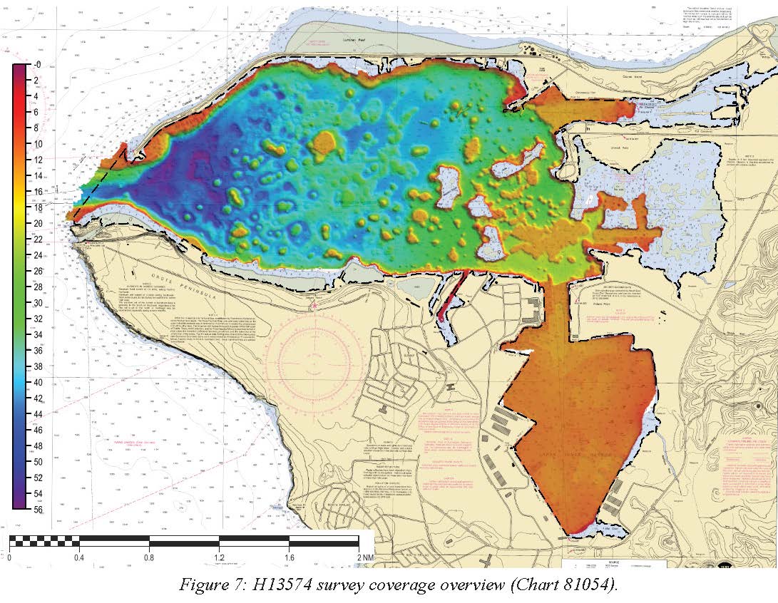
H13574: NOS Hydrographic Survey , 2022-07-09 recent views
National Oceanic and Atmospheric Administration, Department of Commerce —
The National Oceanic and Atmospheric Administration (NOAA) has the statutory mandate to collect hydrographic data in support of nautical chart compilation for safe... -
Federal
CHIRP high-resolution seismic profiles from the West Mariana Ridge recent views
National Oceanic and Atmospheric Administration, Department of Commerce —
SEG-Y Knudsen 320BR CHIRP data collected simultaneously with multibeam bathymetry and acoustic backscatter.

Official websites use .gov
A
.gov website belongs to an official government
organization in the United States.
Secure .gov websites use HTTPS
A
lock (
) or https:// means you’ve safely connected to
the .gov website. Share sensitive information only on official,
secure websites.