
-
Federal
Sea Level Trends: Sea Level Variations of the United States Derived from National Water Level Observation Network Stations NGDA recent views
National Oceanic and Atmospheric Administration, Department of Commerce —
Water level records are a combination of the fluctuations of the ocean and the vertical land motion at the location of the station. Monthly mean sea level (MSL)... -
Federal
Airborne Gravity Data - Gravity for the Redefinition of the American Vertical Datum (GRAV-D) NGDA recent views
National Oceanic and Atmospheric Administration, Department of Commerce —
Gravity for the Re-definition of the American Vertical Datum (GRAV-D) is a project initiated by NOAA's National Geodetic Survey to collect and monitor gravity data... -
Federal
National Coral Reef Monitoring Program: Stratified Random Surveys (StRS) of Reef Fish, including Benthic Estimate Data of the Mariana Archipelago since 2014 recent views
National Oceanic and Atmospheric Administration, Department of Commerce —
The stationary point count (SPC) method is used to conduct reef fish surveys in the Hawaiian and Mariana Archipelagos, American Samoa, and the Pacific Remote Island... -
Federal
High Tide Flooding Products from NOAA CO-OPS recent views
National Oceanic and Atmospheric Administration, Department of Commerce —
High tide flooding is the overflow or excess accumulation of water that covers typically dry coastal land and occurs during high tides. As relative sea levels rise,... -
Federal
Meteorological Data (including visibility) recent views
National Oceanic and Atmospheric Administration, Department of Commerce —
The National Ocean Service (NOS) maintains a long-term database containing data from active and historic stations installed all over the United States and U.S.... -
Federal
Hard and Soft Bottom Seafloor Substrate Maps Derived from an Unsupervised Classification of Gridded Backscatter at Select U.S. Locations in the Pacific recent views
National Oceanic and Atmospheric Administration, Department of Commerce —
Substrate, Hard bottom vs. Soft bottom: This is a preliminary product. Cell values reflect whether the seafloor is hard bottom or soft bottom based on an unsupervised... -
Federal
EM300 Multibeam Sonar Data collected from May 7 to May 22 from NOAA Ship Hi'ialakai cruise HA-17-01 to the Commonwealth of Northern Mariana Islands (CNMI) and Guam in 2017 recent views
National Oceanic and Atmospheric Administration, Department of Commerce —
Multibeam data were collected using a Simrad EM300 30-kHz sonar aboard NOAA Ship Hi'ialakai, a 68-m (218') NOAA research vessel, from May 7 to May 22, 2017 during... -
Federal
W00006: NOS Hydrographic Survey , Outside Source Data - 2001, 2001-03-20 recent views
National Oceanic and Atmospheric Administration, Department of Commerce —
The National Oceanic and Atmospheric Administration (NOAA) has the statutory mandate to collect hydrographic data in support of nautical chart compilation for safe... -
Federal
H13577: NOS Hydrographic Survey , 2022-06-02 recent views
National Oceanic and Atmospheric Administration, Department of Commerce —
The National Oceanic and Atmospheric Administration (NOAA) has the statutory mandate to collect hydrographic data in support of nautical chart compilation for safe... -
Federal
W00157: NOS Hydrographic Survey , Outside Source Data Surveys - 2009, 2003-09-29 recent views
National Oceanic and Atmospheric Administration, Department of Commerce —
The National Oceanic and Atmospheric Administration (NOAA) has the statutory mandate to collect hydrographic data in support of nautical chart compilation for safe... -
Federal
Mariana Trench 6 arc-second Bathymetric Digital Elevation Model recent views
National Oceanic and Atmospheric Administration, Department of Commerce —
NOAA's National Geophysical Data Center (NGDC) created a bathymetric digital elevation model (DEM) for the Mariana Trench and adjacent seafloor in the Western Pacific... -
Federal
NOAA Water Levels for Coastal, Estuaries and Great Lakes regions recent views
National Oceanic and Atmospheric Administration, Department of Commerce —
For over 200 years, NOAA's Center for Operational Oceanographic Products and Services (CO-OPS) and its predecessors have been managing a comprehensive system for... -
Federal
Guam 1/3 arc-second MHW Coastal Digital Elevation Model recent views
National Oceanic and Atmospheric Administration, Department of Commerce —
The 1/3-second Guam Elevation Grid provides bathymetric data of 1/3-second resolution in geographic coordinates. This grid is strictly for tsunami inundation modeling -
Federal
Guam Long-term Coral Reef Monitoring Program Benthic Images since 2010 recent views
National Oceanic and Atmospheric Administration, Department of Commerce —
The Government of Guam's Comprehensive Long-term Monitoring at Permanent Sites in Guam project, also known as the Guam Long-term Coral Reef Monitoring Program... -
Federal
Guam Long-term Coral Reef Monitoring Program Benthic Cover Derived from Analysis of Benthic Images since 2010 recent views
National Oceanic and Atmospheric Administration, Department of Commerce —
The Government of Guam's Comprehensive Long-term Monitoring at Permanent Sites in Guam project, also known as the Guam Long-term Coral Reef Monitoring Program... -
Federal
Pacific Reef Assessment and Monitoring Program: Water Chemistry of the Coral Reefs across the U.S.-affiliated Pacific Islands from Water Samples collected from 2012 to 2014 recent views
National Oceanic and Atmospheric Administration, Department of Commerce —
Water samples are collected and analyzed to assess spatial and temporal variation in the seawater carbonate systems of coral reef ecosystems in the Hawaiian and... -
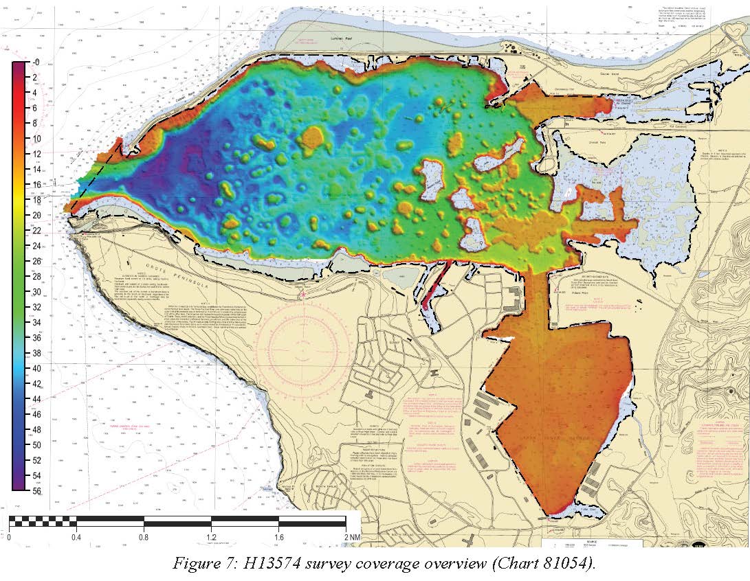
Federal
H13574: NOS Hydrographic Survey , 2022-07-09 recent views
National Oceanic and Atmospheric Administration, Department of Commerce —
The National Oceanic and Atmospheric Administration (NOAA) has the statutory mandate to collect hydrographic data in support of nautical chart compilation for safe... -
Federal
CHIRP high-resolution seismic profiles from the West Mariana Ridge recent views
National Oceanic and Atmospheric Administration, Department of Commerce —
SEG-Y Knudsen 320BR CHIRP data collected simultaneously with multibeam bathymetry and acoustic backscatter. -
Federal
Raw Knudsen KEB Datagrams from CHIRP High-Resolution Seismic Profiles from the West Mariana Ridge recent views
National Oceanic and Atmospheric Administration, Department of Commerce —
Raw Knudsen KEB Datagrams collected simultaneously with multibeam bathymetry and acoustic backscatter. -
Federal
CO-OPS Water Level Data from the Coastal Tide Gauge and Great Lake Water Level Network of the United States and US Territories recent views
National Oceanic and Atmospheric Administration, Department of Commerce —
The Center for Operational Oceanographic Products and Services (CO-OPS) of the National Ocean Service (NOS), an organizational element of NOAA, operates and maintains...

Official websites use .gov
A
.gov website belongs to an official government
organization in the United States.
Secure .gov websites use HTTPS
A
lock (
) or https:// means you’ve safely connected to
the .gov website. Share sensitive information only on official,
secure websites.