
-
Federal
VEMAP 2: Annual Ecosystem Model Responses to U.S. Climate Change, 1994-2100 recent views
National Aeronautics and Space Administration —
Phase 2 of the VEMAP Project developed historical (1895-1993) gridded data sets of climate (temperature, precipitation, solar radiation, humidity, and wind speed) and... -
Federal
Global Land Cover Mapping and Estimation Yearly 30 m V001 recent views
National Aeronautics and Space Administration —
NASA’s Making Earth System Data Records for Use in Research Environments (MEaSUREs) Global Land Cover Mapping and Estimation (GLanCE) annual 30 meter (m) Version 1... -
Federal
NACP Integrated Wildland and Cropland 30-m Fuel Characteristics Map, U.S.A., 2010 recent views
National Aeronautics and Space Administration —
The data set provides a 30-m comprehensive fuelbed characteristics map for both the wildland and cropland areas of the conterminous United States (CONUS) for 2010.... -
Federal
Forest Inventory and Biophysical Measurements, Brazilian Amazon, 2009-2018 recent views
National Aeronautics and Space Administration —
This dataset provides the complete catalog of forest inventory and biophysical measurements collected over selected forest research sites across the Amazon rainforest... -
Federal
MERRA-2 tavg1_2d_lnd_Nx: 2d,1-Hourly,Time-Averaged,Single-Level,Assimilation,Land Surface Diagnostics 0.625 x 0.5 degree V5.12.4 (M2T1NXLND) at GES DISC recent views
National Aeronautics and Space Administration —
M2T1NXLND (or tavg1_2d_lnd_Nx) is an hourly time-averaged 2-dimensional data collection in Modern-Era Retrospective analysis for Research and Applications version 2... -
Federal
NLDAS Noah Land Surface Model L4 Monthly 0.125 x 0.125 degree V2.0 (NLDAS_NOAH0125_M) at GES DISC recent views
National Aeronautics and Space Administration —
This data set contains fifty-two fields simulated from the Noah land-surface model (LSM) for Phase 2 of the North American Land Data Assimilation System (NLDAS-2).... -
Federal
NACP Site: Terrestrial Biosphere Model and Aggregated Flux Data in Standard Format recent views
National Aeronautics and Space Administration —
This data set provides standardized output variables for gross primary productivity (GPP), net ecosystem exchange (NEE), leaf area index (LAI), ecosystem respiration... -
Federal
LiDAR Derived Biomass, Canopy Height, and Cover for New England Region, USA, 2015 recent views
National Aeronautics and Space Administration —
This dataset provides 30 m gridded estimates of aboveground biomass density (AGBD), forest canopy height, and tree canopy coverage for the New England Region of the... -
Federal
Fire Intensity and Burn Severity Metrics for Circumpolar Boreal Forests, 2001-2013 NGDA recent views
National Aeronautics and Space Administration —
This data set provides products characterizing immediate and longer-term ecosystem changes from fires in the circumpolar boreal forests of Northern Eurasia and North... -
Federal
NPP Tropical Forest: Maui, Hawaii, U.S.A., 1996-1997, R1 recent views
National Aeronautics and Space Administration —
This data set contains one data file (.csv format) that quantifies net primary productivity (NPP) as a function of rainfall in mesic to wet montane rainforests on the... -
Federal
Siberian Boreal Forest Aboveground Biomass and Fire Scar Maps, Russia, 1969-2007 NGDA recent views
National Aeronautics and Space Administration —
This data set provides 30-meter resolution mapped estimates of Cajander larch (Larix cajanderi) aboveground biomass (AGB), circa 2007, and a map of burn perimeters... -
Federal
ABoVE: Photochemical Reflectance and Tree Growth, Brooks Range, Alaska, 2018-2019 recent views
National Aeronautics and Space Administration —
This dataset provides simultaneous in-situ measurements of the photochemical reflectance index (PRI) and radial tree growth of selected white spruce trees (Picea... -
Federal
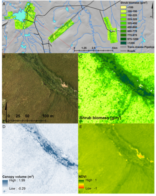
High-Resolution Shrub Biomass and Uncertainty Maps, Toolik Lake Area, Alaska, 2013 recent views
National Aeronautics and Space Administration —
This dataset contains estimates for aboveground shrub biomass and uncertainty at high spatial resolution (0.80-m) across three research areas near Toolik Lake,... -
Federal
ABoVE: Needle-Level Chlorophyll Fluorescence, Alaska and Idaho, USA, 2017 and 2019 recent views
National Aeronautics and Space Administration —
This dataset provides the results of in situ measurements of needle-level chlorophyll fluorescence (ChlF) obtained from a pulse amplitude modulated (PAM) fluorometer... -
Federal
Arctic Vegetation Plots for IBP Tundra Biome, Barrow, Alaska, 1972-2010 recent views
National Aeronautics and Space Administration —
This data set provides vegetation cover and environmental plot data collected as part of the International Biological Program (IBP), U. S. Tundra Biome Program, in... -
Federal
Arctic Vegetation Plots at Toolik Lake, Alaska, 1989 recent views
National Aeronautics and Space Administration —
This dataset provides environmental, soil, and vegetation data collected in August 1989 from 81 study plots at the Toolik Lake research site, located in the southern... -
Federal
LBA-ECO TG-07 Ground-based Biometry Data at km 83 Site, Tapajos National Forest: 1997 recent views
National Aeronautics and Space Administration —
A field inventory of trees was conducted in March of 1997 in a logging concession at the Tapajos National Forest, south of Santarem, Para, Brazil. The inventory was... -
Federal
BigFoot Field Data for North American Sites, 1999-2003 recent views
National Aeronautics and Space Administration —
The BigFoot project gathered field data for selected EOS Land Validation Sites in North America from 1999 to 2003. Data collected and derived for varying intervals at... -
Federal
CMS: LiDAR-derived Biomass, Canopy Height and Cover, Sonoma County, California, 2013 recent views
National Aeronautics and Space Administration —
This data set provides estimates of above-ground biomass (AGB), canopy height, and percent tree cover at 30-m spatial resolution for Sonoma County, California, USA,... -
Federal
GEDI L4A Footprint Level Aboveground Biomass Density, Version 2.1 recent views
National Aeronautics and Space Administration —
This dataset contains Global Ecosystem Dynamics Investigation (GEDI) Level 4A (L4A) Version 2 predictions of the aboveground biomass density (AGBD; in Mg/ha) and...

Official websites use .gov
A
.gov website belongs to an official government
organization in the United States.
Secure .gov websites use HTTPS
A
lock (
) or https:// means you’ve safely connected to
the .gov website. Share sensitive information only on official,
secure websites.