
-
Federal
U.S. Counties FIPS Layer
Department of Energy —
This dataset, which represents county Federal Information Processing System (FIPS) codes for each county as a raster, is utilized by reVX to compute setbacks... -
Federal
United States Utility-Scale PV Supply Curves 2024
Department of Energy —
This data packet contains supply curves, hourly generation profiles, and a composite siting exclusion TIFF for utility-scale PV across the contiguous United States.... -
Federal
H13734: NOS Hydrographic Survey , 2023-08-17
National Oceanic and Atmospheric Administration, Department of Commerce —
The National Oceanic and Atmospheric Administration (NOAA) has the statutory mandate to collect hydrographic data in support of nautical chart compilation for safe... -
Federal
Physical Solar Model version 3 Global Horizontal Irradiance Multi-year Annual Average
Department of Energy —
This data provides annual average daily total solar resource averaged over surface cells of 0.038 degrees in both latitude and longitude, or nominally 4 km in size.... -
Federal
Wind Turbine Water Setbacks: Ordinances (2022) and Extrapolated Trends, 115 Hub Height 170 Rotor Diameter
Department of Energy —
This dataset represents wind energy setback requirements from water based on existing county ordinances as of April 2022. A setback requirement is a minimum distance... -
Federal
Fallon FORGE: Well Data, Geophysical Data, and Geologic Maps
Department of Energy —
The data is associated to the Fallon FORGE project and includes mudlogs for all wells used to characterize the subsurface, as wells as gravity, magnetotelluric,... -
Federal
United States Land-based Wind Supply Curves 2024
Department of Energy —
This data packet contains supply curves, hourly generation profiles, and a composite siting exclusion TIFF for land-based wind across the contiguous United States.... -
Federal
F00909: NOS Hydrographic Survey , 2024-09-30
National Oceanic and Atmospheric Administration, Department of Commerce —
The National Oceanic and Atmospheric Administration (NOAA) has the statutory mandate to collect hydrographic data in support of nautical chart compilation for safe... -
Federal
EMAG2: Earth Magnetic Anomaly Grid (2-arc-minute resolution)
National Oceanic and Atmospheric Administration, Department of Commerce —
EMAG2 is a global Earth Magnetic Anomaly Grid compiled from satellite, ship, and airborne magnetic measurements. It is a significant update of our previous candidate... -
Federal
F00919: NOS Hydrographic Survey , 2025-06-03
National Oceanic and Atmospheric Administration, Department of Commerce —
The National Oceanic and Atmospheric Administration (NOAA) has the statutory mandate to collect hydrographic data in support of nautical chart compilation for safe... -
Federal
H12572: NOS Hydrographic Survey , Delaware Bay and Approaches, 2013-09-16
National Oceanic and Atmospheric Administration, Department of Commerce —
The National Oceanic and Atmospheric Administration (NOAA) has the statutory mandate to collect hydrographic data in support of nautical chart compilation for safe... -
Federal
F00646: NOS Hydrographic Survey , 2014-10-22
National Oceanic and Atmospheric Administration, Department of Commerce —
The National Oceanic and Atmospheric Administration (NOAA) has the statutory mandate to collect hydrographic data in support of nautical chart compilation for safe... -
Federal
Characterization data on the effects of micro-computed tomography-based x-ray radiation on vinyl nitrile foam
Department of Commerce —
This dataset contains information from investigating the effects of micro-computed tomographic imaging irradiation on vinyl nitrile foam and code for a finite element... -
Federal
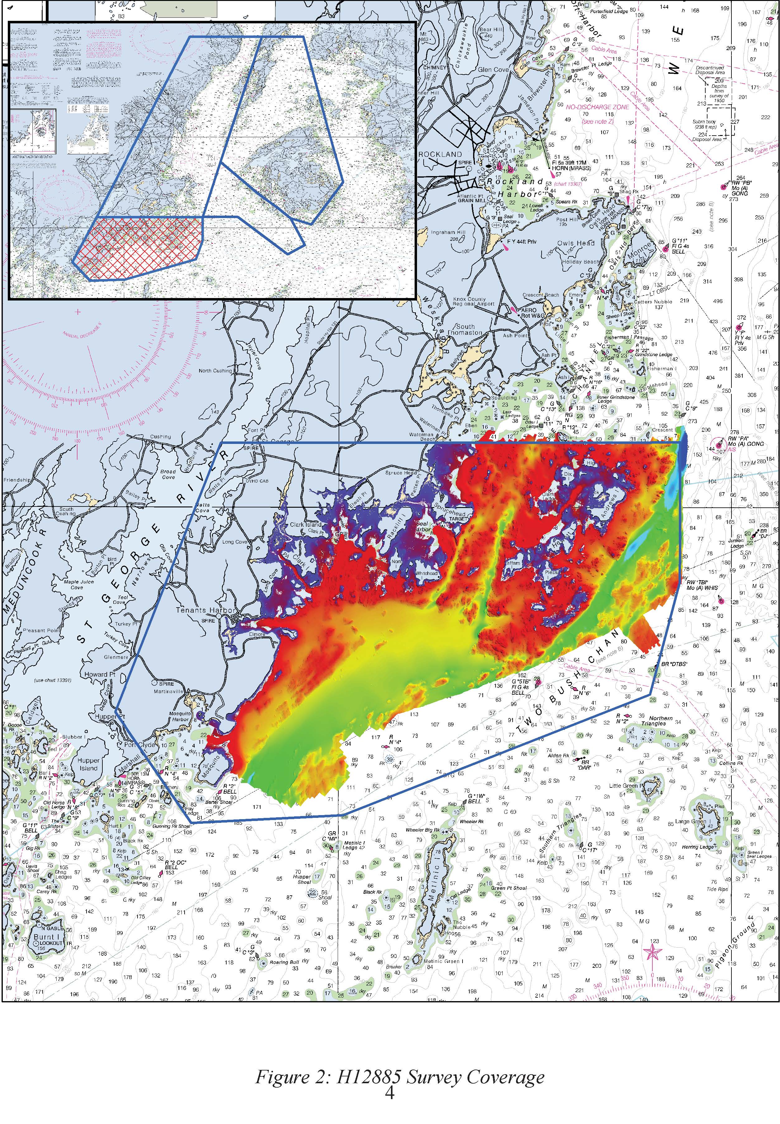
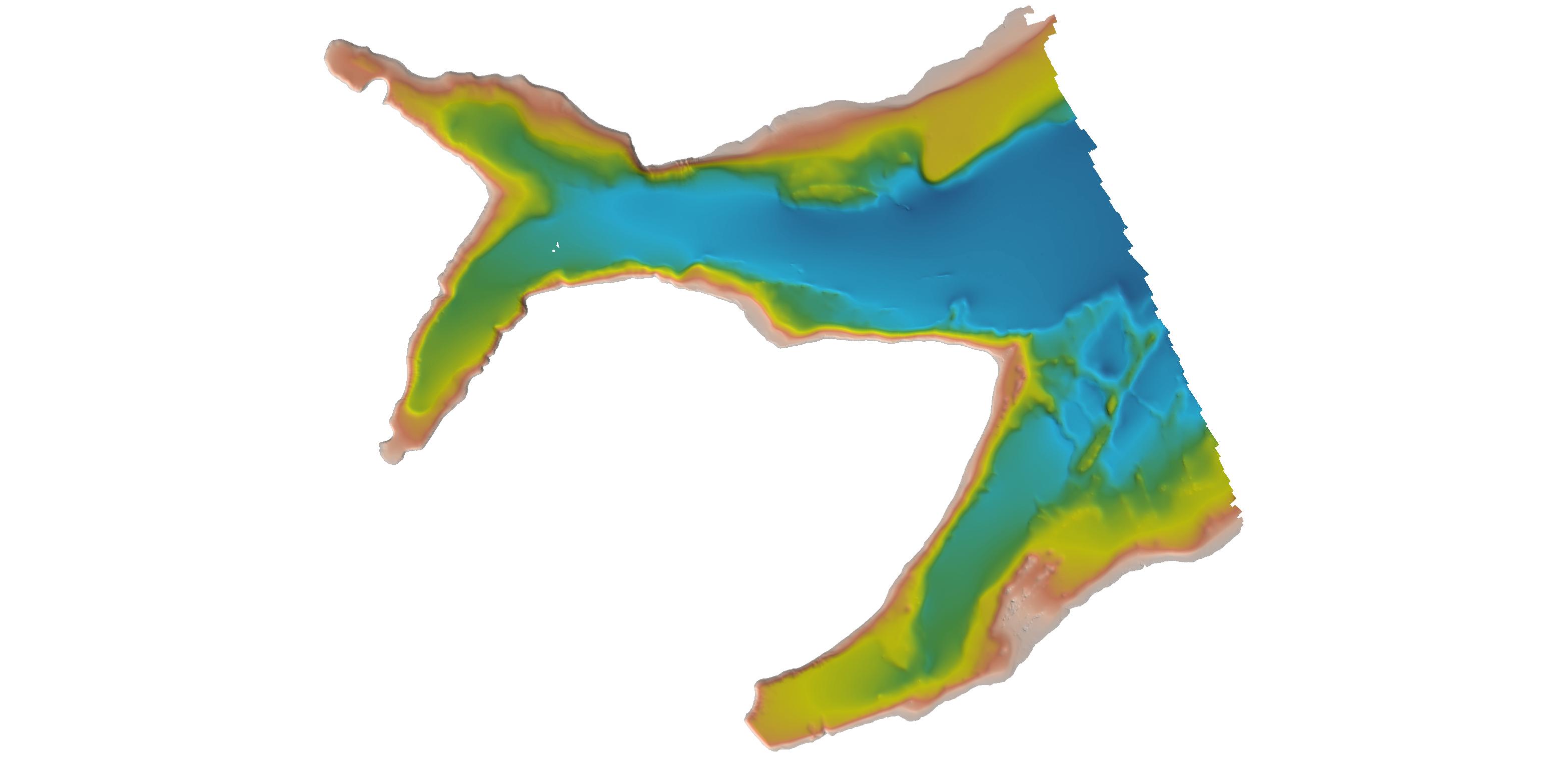
H12885: NOS Hydrographic Survey , 2016-09-29
National Oceanic and Atmospheric Administration, Department of Commerce —
The National Oceanic and Atmospheric Administration (NOAA) has the statutory mandate to collect hydrographic data in support of nautical chart compilation for safe... -
Federal
H11195: NOS Hydrographic Survey , Southwest Alaska Peninsula, Alaska, 2003-06-06
National Oceanic and Atmospheric Administration, Department of Commerce —
The National Oceanic and Atmospheric Administration (NOAA) has the statutory mandate to collect hydrographic data in support of nautical chart compilation for safe... -
Federal
H13449: NOS Hydrographic Survey , 2021-07-21
National Oceanic and Atmospheric Administration, Department of Commerce —
The National Oceanic and Atmospheric Administration (NOAA) has the statutory mandate to collect hydrographic data in support of nautical chart compilation for safe... -
Federal
H13838: NOS Hydrographic Survey , 2024-02-03
National Oceanic and Atmospheric Administration, Department of Commerce —
The National Oceanic and Atmospheric Administration (NOAA) has the statutory mandate to collect hydrographic data in support of nautical chart compilation for safe... -
Federal
Wind Integration National Dataset (WIND) Toolkit - Multi-year Annual Average - Mexico
Department of Energy —
This data provides modeled annual average wind speed for Mexico and surrounding areas both onshore and offshore for the period 2007–2013. This dataset was derived... -
Federal
Wind Turbine Sound Setbacks and Supply Curves: Ordinances and Extrapolated Trends, 110 Hub Height, 130 Rotor Diameter
Department of Energy —
This dataset provides a comprehensive set of wind turbine sound setbacks from every residential structure in the contiguous United States (CONUS). A sound setback is... -
Federal
H13207: NOS Hydrographic Survey , 2019-12-04
National Oceanic and Atmospheric Administration, Department of Commerce —
The National Oceanic and Atmospheric Administration (NOAA) has the statutory mandate to collect hydrographic data in support of nautical chart compilation for safe...

Official websites use .gov
A
.gov website belongs to an official government
organization in the United States.
Secure .gov websites use HTTPS
A
lock (
) or https:// means you’ve safely connected to
the .gov website. Share sensitive information only on official,
secure websites.
.jpg)