
-
Federal
Digital Geologic-GIS Map of Joshua Tree National Park, California (NPS, GRD, GRI, JOTR, JOTR digital map) adapted from a U.S. Geological Survey Open-File Report map by Powell, Matti and Cossette (2015), and an ESRI USA Topo Web Map Service map (2013)
Department of the Interior —
The Digital Geologic-GIS Map of Joshua Tree National Park, California is composed of GIS data layers and GIS tables, and is available in the following GRI-supported... -
Federal
Wind speed estimates of the December 2021 Quad-State Tornado in Mayfield, KY based on treefall pattern analysis
Department of Commerce —
A violent tornado outbreak occurred on December 10-11, 2021 in the Midwest US. One of the tornadoes, known as the Quad-State tornado, tracked across four states and... -
Federal
NOAA/WDS Paleoclimatology - Heyerdahl fire data from Crane Lookout - IMPD USCRN002
National Oceanic and Atmospheric Administration, Department of Commerce —
This archived Paleoclimatology Study is available from the NOAA National Centers for Environmental Information (NCEI), under the World Data Service (WDS) for... -
Federal
MODIS/Terra Vegetation Continuous Fields Yearly L3 Global 250m SIN Grid V061
National Aeronautics and Space Administration —
The MOD44B Version 6.1 Vegetation Continuous Fields (VCF) yearly product is a global representation of surface vegetation cover as gradations of three ground cover... -
Federal
MODIS/Terra Land Water Mask Derived from MODIS and SRTM L3 Global 250m SIN Grid V006
National Aeronautics and Space Administration —
The MOD44W Version 6 data product was decommissioned on July 18, 2024. Users are encouraged to use the MOD44W Version 6.1 data product... -
Federal
MODIS/Terra Vegetation Continuous Fields Yearly L3 Global 250m SIN Grid V006
National Aeronautics and Space Administration —
The MOD44B Version 6 data product was decommissioned on July 31, 2023. Users are encouraged to use the MOD44B Version 6.1 data product.The MOD44B Version 6 Vegetation... -
Federal
Wind speed estimates of the December 2021 Quad-State Tornado in Mayfield, KY based on treefall pattern analysis
National Institute of Standards and Technology —
A violent tornado outbreak occurred on December 10-11, 2021 in the Midwest US. One of the tornadoes, known as the Quad-State tornado, tracked across four states and... -
Federal
NOAA/WDS Paleoclimatology - Baisan fire data from Eagle Feather - IMPD USEGF001
National Oceanic and Atmospheric Administration, Department of Commerce —
This archived Paleoclimatology Study is available from the NOAA National Centers for Environmental Information (NCEI), under the World Data Service (WDS) for... -
Federal
Benthic, urchin, and fish observation data collected utilizing multiple methodologies for coral reef carbonate budget assessments in 2021 in O'ahu, in the Mariana Archipelago in 2022, and in American Samoa in 2023
National Oceanic and Atmospheric Administration, Department of Commerce —
This data package includes the benthic, urchin, and fish observation data collected for coral reef carbonate budget assessments by the Ecosystem Sciences Division... -
Federal
NACP Aboveground Biomass and Carbon Baseline Data, V.2 (NBCD 2000), U.S.A., 2000
National Aeronautics and Space Administration —
The NBCD 2000 (National Biomass and Carbon Dataset for the Year 2000) data set provides a high-resolution (30 m) map of year-2000 baseline estimates of basal area-... -
Federal
BOREAS TE-23 Map Plot Data
National Aeronautics and Space Administration —
The BOREAS TE-23 team collected map plot data in support of its efforts to characterize and interpret information on canopy architecture and understory cover at the... -
Federal
NOAA/WDS Paleoclimatology - Brown fire data from Bannock Creek - IMPD USBAN001
National Oceanic and Atmospheric Administration, Department of Commerce —
This archived Paleoclimatology Study is available from the NOAA National Centers for Environmental Information (NCEI), under the World Data Service (WDS) for... -
Federal
2024 IN DNR Lidar DEM: Indiana Coastline
National Oceanic and Atmospheric Administration, Department of Commerce —
Original Product: These are Digital Elevation Model (DEM) data as part of the required deliverables for the lidar project. Class 2 (Ground) lidar points in... -
Federal
NOAA/WDS Paleoclimatology - Veblen fire data from BM39 - IMPD USBM-039
National Oceanic and Atmospheric Administration, Department of Commerce —
This archived Paleoclimatology Study is available from the NOAA National Centers for Environmental Information (NCEI), under the World Data Service (WDS) for... -
Federal
MODIS/Terra Land Water Mask Derived from MODIS and SRTM L3 Global 250m SIN Grid V061
National Aeronautics and Space Administration —
The Terra Moderate Resolution Imaging Spectroradiometer (MODIS) Land Water Mask (MOD44W) Version 6.1 data product provides a global map of surface water at 250 meter... -
Federal
NOAA/WDS Paleoclimatology - Veblen fire data from BM17 - IMPD USBM-017
National Oceanic and Atmospheric Administration, Department of Commerce —
This archived Paleoclimatology Study is available from the NOAA National Centers for Environmental Information (NCEI), under the World Data Service (WDS) for... -
Federal
Land Use and Cover Maps from Landsat, Mawas, Central Kalimantan, Indonesia, 1994-2019
National Aeronautics and Space Administration —
This dataset contains annual land use/cover (LUC) maps at 30 m resolution across Mawas, Central Kalimantan, Indonesia. There are six files, each representing a five-... -
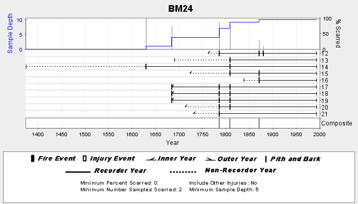
Federal
NOAA/WDS Paleoclimatology - Veblen fire data from BM24 - IMPD USBM-024
National Oceanic and Atmospheric Administration, Department of Commerce —
This archived Paleoclimatology Study is available from the NOAA National Centers for Environmental Information (NCEI), under the World Data Service (WDS) for... -
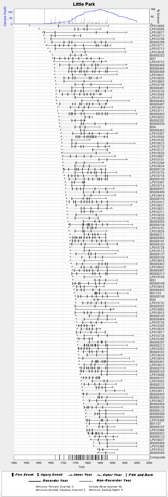
Federal
NOAA/WDS Paleoclimatology - Fulé fire data from Little Park - IMPD USLPK001
National Oceanic and Atmospheric Administration, Department of Commerce —
This archived Paleoclimatology Study is available from the NOAA National Centers for Environmental Information (NCEI), under the World Data Service (WDS) for... -
Federal
Leaf Area Index Maps at 30-m Resolution, VALERI Site, Larose, Canada
National Aeronautics and Space Administration —
This data set provide local LAI maps for the Larose (Ontario) site in Canada. These derived maps may also be useful for validating other LAI maps over this same site...

Official websites use .gov
A
.gov website belongs to an official government
organization in the United States.
Secure .gov websites use HTTPS
A
lock (
) or https:// means you’ve safely connected to
the .gov website. Share sensitive information only on official,
secure websites.