
-
Federal
TP84227_FS83049_OPData
Department of Energy —
The data set represents the data used for the analysis of operational carbon emissions for a carbon case study of a typical production builder's home in two common... -
Federal
SWOT Level 2 Water Mask Raster Image 100m Data Product, Version D
National Aeronautics and Space Administration —
The SWOT Level 2 KaRIn High Rate Raster Product (SWOT_L2_HR_Raster_D) provides rasterized estimates of water surface elevation, inundation extent, and radar... -
Federal
Data and Code for Analysis presented in NIST TN 2137: Quantifying Operational Resilience Benefits of the Smart Grid
National Institute of Standards and Technology —
This MIDAS object contains all the data inputs and code necessary to replicate the findings presented in NIST TN2137 using the statistical software Stata. -
Federal
Data and Code for Analysis presented in NIST TN 2137: Quantifying Operational Resilience Benefits of the Smart Grid
Department of Commerce —
This MIDAS object contains all the data inputs and code necessary to replicate the findings presented in NIST TN2137 using the statistical software Stata. -
Federal
NACP Aboveground Biomass and Carbon Baseline Data, V.2 (NBCD 2000), U.S.A., 2000
National Aeronautics and Space Administration —
The NBCD 2000 (National Biomass and Carbon Dataset for the Year 2000) data set provides a high-resolution (30 m) map of year-2000 baseline estimates of basal area-... -
Federal
HLS Landsat Operational Land Imager Surface Reflectance and TOA Brightness Daily Global 30m v2.0
National Aeronautics and Space Administration —
The Harmonized Landsat Sentinel-2 (HLS) project provides consistent surface reflectance (SR) and top of atmosphere (TOA) brightness data from a virtual constellation... -
Federal
ASTER L2 Surface Reflectance VNIR and SWIR V004
National Aeronautics and Space Administration —
The Terra Advanced Spaceborne Thermal Emission and Reflection Radiometer (ASTER) Surface Reflectance VNIR and SWIR (AST_07) data product contains measures of the... -
Federal
ASTER L2 Surface Reflectance VNIR and Crosstalk Corrected SWIR V004
National Aeronautics and Space Administration —
The Terra Advanced Spaceborne Thermal Emission and Reflection Radiometer (ASTER) Surface Reflectance VNIR and Crosstalk Corrected SWIR (AST_07XT) dataset contains... -
Federal
ASTER L2 Surface Radiance TIR V004
National Aeronautics and Space Administration —
The Terra Advanced Spaceborne Thermal Emission and Reflection Radiometer (ASTER) Surface Radiance TIR (AST_09T) is generated using the five Thermal Infrared (TIR)... -
Federal
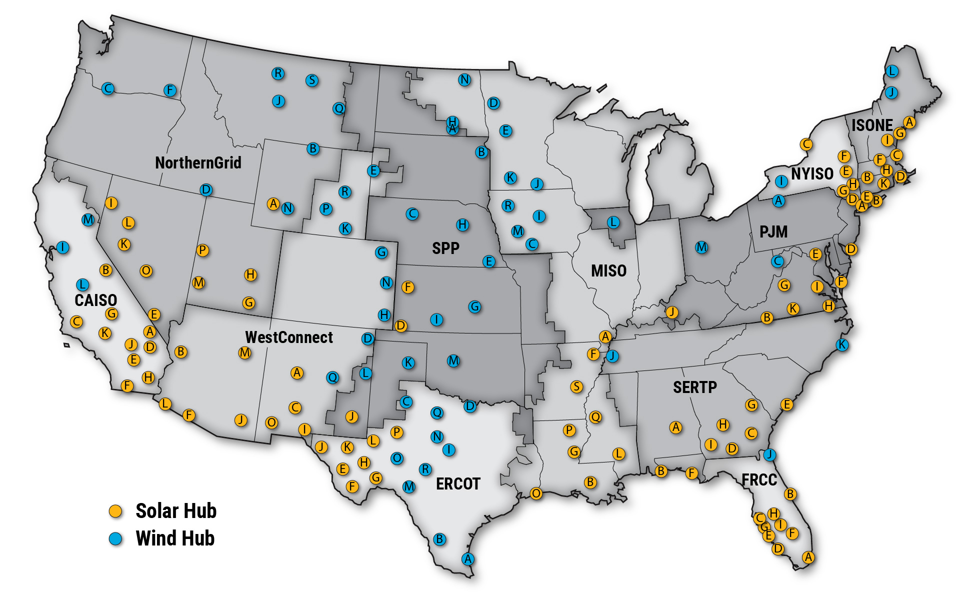
Interregional Renewable Energy Zones
Department of Energy —
Interregional Renewable Energy Zones (IREZs) are a component of the National Transmission Planning Study (NTPS), which analyzes strategies for building out... -
Federal
NARSTO EPA Supersite (SS) Fresno, Particulate Matter (PM) 2.5 Particulate Nitrate and Sulfate Data
National Aeronautics and Space Administration —
The NARSTO_EPA_SS_FRESNO_PM25_NO3_SO4 is the North American Research Strategy for Tropospheric Ozone (NARSTO) Environmental Protection Agency (EPA) Supersite (SS)... -
Federal
ASTER L2 Surface Kinetic Temperature V004
National Aeronautics and Space Administration —
The Terra Advanced Spaceborne Thermal Emission and Reflection Radiometer (ASTER) Surface Kinetic Temperature (AST_08) V004 product delivers surface kinetic... -
Federal
International Satellite Cloud Climatology Project (ISCCP) TOVS in Native Data Format
National Aeronautics and Space Administration —
ISCCP_TOVS_NAT_1 is the International Satellite Cloud Climatology Project (ISCCP) TIROS Operational Vertical Sounder (TOVS) data set in the Native Data Format. It is... -
Federal
ASTER L2 Surface Radiance VNIR and Crosstalk Corrected SWIR V004
National Aeronautics and Space Administration —
The Terra Advanced Spaceborne Thermal Emission and Reflection Radiometer (ASTER) Surface Radiance VNIR and Crosstalk Corrected SWIR (AST_09XT) contains... -
Federal
TP84227_FS83049_ECData
Department of Energy —
The data set represents the data used for the analysis of embodied carbon emissions for a carbon case study of a typical production builder's home in two common... -
Federal
GHRSST Level 4 AVHRR_OI Global Blended Sea Surface Temperature Analysis (GDS version 2) from NCEI
National Aeronautics and Space Administration —
A Group for High Resolution Sea Surface Temperature (GHRSST) global Level 4 sea surface temperature analysis produced daily on a 0.25 degree grid at the NOAA National... -
Federal
First AGILE Catalog of High-Confidence Gamma-Ray Sources
National Aeronautics and Space Administration —
This table contains the first catalog of high-confidence gamma-ray sources detected by the AGILE satellite during observations performed from July 9, 2007 to June 30,... -
Federal
ASTER L2 Surface Emissivity V004
National Aeronautics and Space Administration —
The Terra Advanced Spaceborne Thermal Emission and Reflection Radiometer (ASTER) Surface Emissivity (AST_05) is produced using the Temperature/Emissivity Separation... -
Federal
Coastal Wetland Elevation and Carbon Flux Inventory with Uncertainty, USA, 2006-2011
National Aeronautics and Space Administration —
This dataset provides maps of coastal wetland carbon and methane fluxes and coastal wetland surface elevation from 2006 to 2011 at 30 m resolution for coastal... -
Federal
ASTER L2 Surface Radiance VNIR and SWIR V004
National Aeronautics and Space Administration —
The Terra Advanced Spaceborne Thermal Emission and Reflection Radiometer (ASTER) Surface Radiance VNIR and SWIR (AST_09) contains atmospherically corrected data for...

Official websites use .gov
A
.gov website belongs to an official government
organization in the United States.
Secure .gov websites use HTTPS
A
lock (
) or https:// means you’ve safely connected to
the .gov website. Share sensitive information only on official,
secure websites.