

11 datasets found for "SSURGO"
-
Federal
Soil Survey Geographic Database (SSURGO) NGDA
Department of Agriculture —
This dataset is a digital soil survey and generally is the most detailed level of soil geographic data developed by the National Cooperative Soil Survey. The... -
Federal
Gridded Soil Survey Geographic (gSSURGO-30) Database for the Conterminous United States - 30 meter NGDA
Department of Agriculture —
This dataset is called the Gridded SSURGO (gSSURGO) Database and is derived from the Soil Survey Geographic (SSURGO) Database. SSURGO is generally the most detailed... -
Federal
Sediment Export to Nearshore Waters - Hawaii
National Oceanic and Atmospheric Administration, Department of Commerce —
This raster data layer represents sediment plumes originating from stream mouths and coastal pour points. The Integrated Valuation of Ecosystem Services and Tradeoffs... -
Federal
Forest Aboveground Biomass and Carbon Sequestration Potential for Maryland, USA.
National Aeronautics and Space Administration —
This dataset provides 90-m resolution maps of estimated forest aboveground biomass (Mg/ha) for nominal year 2011 and projections of carbon sequestration potential for... -
Federal
Map of ecological sites and ecological states for the USDA Jornada Experimental Range
Department of Agriculture —
This data package includes an ArcMap geodatabase: a polygon feature class, associated attribute table and metadata. The spatial data, JERStateMap_v1.gdb.zip,... -
Federal
Final spatial and tabular poplar biomass estimates for Minnesota and Wisconsin, USA based on the approach for siting poplar energy production systems to increase productivity and associated ecosystem services
Department of Agriculture —
Short rotation woody crops such as Populus spp. and their hybrids (i.e., poplars) are a significant component of the total biofuels and bioenergy feedstock resource... -
Federal
Map of ecological sites and ecological states for pastures 1, 4, 14, and 15 on the Chihuahuan Desert Rangeland Research Center, New Mexico
Department of Agriculture —
This data package includes an ArcMap geodatabase for the Chihuahuan Desert Rangeland Research Center (CDRRC) pastures 1, 4, 14, and 15: one polygon feature class, one... -
Federal
BLM Natl FIAT Potential Ecosystem Resilience and Resistance in Sagebrush Habitat 2015 Integer Raster
Department of the Interior —
A 30 meter integer grid representing ecosystem resilience and resistance in sagebrush habitat. “Resilience” and “resistance” to rangeland fire is the basis of the... -
Federal
Tidal Wetland Soil Carbon Stocks for the Conterminous United States, 2006-2010
National Aeronautics and Space Administration —
This dataset provides modeled estimates of soil carbon stocks for tidal wetland areas of the Conterminous United States (CONUS) for the period 2006-2010. Wetland... -
Federal
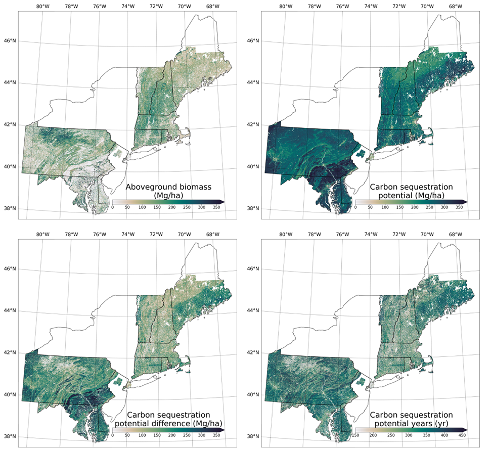
Forest Aboveground Biomass and Carbon Sequestration Potential, Northeastern USA
National Aeronautics and Space Administration —
This dataset provides 90 m estimates of forest aboveground biomass (Mg/ha) for nominal 2011 and projections of carbon sequestration potential for 11 states in the... -
Federal
BLM Natl FIAT Potential Ecosystem Resilience and Resistance in Sagebrush Habitat 2015 Integer Raster
Department of the Interior —
A 30 meter integer grid representing ecosystem resilience and resistance in sagebrush habitat. “Resilience” and “resistance” to rangeland fire is the basis of the...
11 datasets found for "SSURGO"